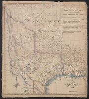
From Maillard's History of the Republic of Texas. London : Smith, Elder and Co., 1842., From the Streeter collection., Includes text., Library's copy annotated in pencil., Relief shown by hachures., and Shows "political, conventional and natural" boundaries of Texas, Indian tribes, Osage Territory, "Santa Fe, formerly New Mexico," and "Indian Territory attached to Arkansas."
Publisher:
Smith, Elder and Co.],
Subject (Geographic):
Mexico--Boundaries--Texas--Maps, Texas--Boundaries--Mexico--Maps, Texas--Boundaries--United States--Maps, Texas--Maps, and United States--Boundaries--Texas--Maps
Subject (Name):
Day & Haghe, Maillard, N. Doran (Nicholas Doran). History of the Republic of Texas, from the discovery of the country to the present time, and Streeter, Thomas W.--(Thomas Winthrop),--1883-1965--Ownership
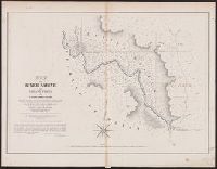
" ... it appears from a letter of J.H. Overton, United States Commissioner, dated Opelousas, Louisiana, August 10 1841 ... and the reply of October 1, 1841 ... that the maps ... had not been forwarded at that time. However, they had been received by January 15, 1842 ... and that they were issued by March 17, 1842, is shown by the reprintings of them accompanying the President's message of that date"--Streeter, Bibliography of Texas, 1438., From the Streeter collection., Includes text., and Relief shown by hachures.
Publisher:
s.n.,
Subject (Geographic):
Sabine River (Tex. and La.)--Maps, Texas--Boundaries--United States--Maps, and United States--Boundaries--Texas--Maps
Subject (Name):
Streeter, Thomas W.--(Thomas Winthrop),--1883-1965--Ownership
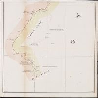
"Though the map ... has an 1840 date, it appears from a letter of J.H. Overton, United States Commissioner, dated Opelousas, Louisiana, August 10, 1841 ... and the reply of October 1, 1841 ... that the maps ... had not been forwarded at that time. However, they had been received by January 15, 1842 ... and that they were issued by March 17, 1842, is shown by the reprintings of them accompanying the President's message of that date"--Streeter, Bibliography of Texas, 1438., From the Streeter collection., Includes text and table., and Relief shown by hachures and depths shown by soundings.
Publisher:
s.n.,
Subject (Geographic):
Louisiana--Boundaries--Texas--Maps, Sabine River (Tex. and La.)--Maps, Texas--Boundaries--Louisiana--Maps, Texas--Boundaries--United States--Maps, and United States--Boundaries--Texas--Maps
Subject (Name):
Graham, J. D. (James Duncan), 1799-1865, Gray, A. B. (Andrew Belcher), 1820-1862, Haas, P, Meade, George Gordon, 1815-1872, Pillans, P.J. (Palmer Job), 1816-1898, and Streeter, Thomas W.--(Thomas Winthrop
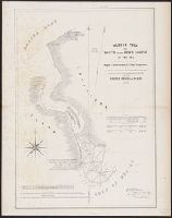
"Though the map ... has an 1840 date, it appears from a letter of J.H. Overton, United States Commissioner, dated Opelousas, Louisiana, August 10, 1841 ... and the reply of October 1, 1841 ... that the maps ... had not been forwarded at that time. However, they had been received by January 15, 1842 ..and that they were issued by March 17, 1842, is shown by the reprintings of them accompanying the President's message of that date"--Streeter, Bibliographof Texas, 1438., At head of title: A.2., From the Streeter collection., Relief shown by hachures., and Three parallel sections of 12 miles each.
Publisher:
s.n.,
Subject (Geographic):
Texas--Boundaries--United States--Maps and United States--Boundaries--Texas--Maps
Subject (Name):
Streeter, Thomas W.--(Thomas Winthrop),--1883-1965--Ownership
Part of the boundary between the United States and Texas, north of Sabine River from the 36th to the 72nd mile mound
Description:
"Though the map ... has an 1840 date, it appears from a letter of J.H. Overton, United States Commissioner, dated Opelousas, Louisiana, August 10, 1841 ... and the reply of October 1, 1841 ... that the maps ... had not been forwarded at that time. However, they had been received by January 15, 1842 ... and that they were issued by March 17, 1842, is shown by the reprintings of them accompanying the President's message of that date"--Streeter, T.W. Bibliography of Texas, 1438., At head of title: B.2., From the Streeter collection., Relief shown by hachures., and Three parallel sections of 12 miles each.
Publisher:
s.n.,
Subject (Geographic):
Texas--Boundaries--United States--Maps and United States--Boundaries--Texas--Maps
Subject (Name):
Streeter, Thomas W.--(Thomas Winthrop),--1883-1965--Ownership
"Though the map ... has an 1840 date, it appears from a letter of J.H. Overton, United States Commissioner, dated Opelousas, Louisiana, August 10, 1841 ... and the reply of October 1, 1841 ... that the maps ... had not been forwarded at that time. However, they had been received by January 15, 1842 ... and that they were issued by March 17, 1842, is shown by the reprintings of them accompanying the President's message of that date"--Streeter, T.W. Bibliography of Texas, 1438., At head of title: C.2., From the Streeter collection., and Three parallel sections, two of twelve miles each and one of 10 miles.
Publisher:
s.n.,
Subject (Geographic):
Texas--Boundaries--United States--Maps and United States--Boundaries--Texas--Maps
Subject (Name):
Streeter, Thomas W.--(Thomas Winthrop),--1883-1965--Ownership
"Though the map ... has an 1840 date, it appears from a letter of J.H. Overton, United States Commissioner, dated Opelousas, Louisiana, August 10 1841 ... and the reply of October 1, 1841 ... that the maps ... had not been forwarded at that time. However, they had been received by January 15, 1842 ... and that they were issued by March 17, 1842, is shown by the reprintings of them accompanying the President's Message of that date"--Streeter, Bibliography of Texas, 1438.
Publisher:
s.n.,
Subject (Geographic):
Sabine River (Tex. and La.)--Maps, Texas--Boundaries--United States--Maps, and United States--Boundaries--Texas--Maps
Subject (Name):
Graham, J. D. (James Duncan), 1799-1865, Pillans, P.J. (Palmer Job), 1816-1898, and Streeter, Thomas W.--(Thomas Winthrop),--1883-1965--Ownership