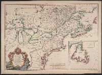
Appears in various eds. of Atlas geographicus maior., Includes German text relating to English and French territorial claims., Neat lines measures 45.8 x 50.8 cm. on sheet 50 x 57.5 cm. Ms. note on verso: No. 151, Nord America nach d'Anville. Franklin Collection no. 131 1756-9., Place names and descriptive notes in English., Prime meridian: Ferro and London., and Relief shown pictorially.
Publisher:
[Homann Erben],
Subject (Geographic):
North America--Maps--Early works to 1800 and United States--History--French and Indian War, 1755-1763--Maps--Early works to 1800
Subject (Name):
Anville, Jean Baptiste Bourguignon d', 1697-1782 and Homann Erben (Firm). Atlas geographicus maior
755 1756E: Mounted on paper. Neat line measures 45.9 x 51 cm. on sheet 46 x 51.2 cm. Ms. no.: 54., Includes German text relating to English and French territorial claims., Prime meridian: Ferro and London., Relief sh, and Sheet measures 49.5 x 57.2 cm.
Publisher:
[Homann Erben],
Subject (Geographic):
North America--Maps--Early works to 1800 and United States--History--French and Indian War, 1755-1763--Maps--Early works to 1800
Subject (Name):
Anville, Jean Baptiste Bourguignon d', 1697-1782 and Homann Erben (Firm). Atlas geographicus maior
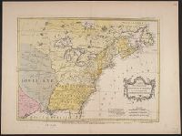
Appears in various eds. of Atlas geographicus maior., Includes German text relating to English and French territorial claims., Mounted on paper. Neat line measures 45.9 x 51 cm. on sheet 46 x 51.2 cm. Ms. no.: 54., and Place names and descriptive notes in Englis
Publisher:
[Homann Erben],
Subject (Geographic):
North America--Maps--Early works to 1800 and United States--History--French and Indian War, 1755-1763--Maps--Early works to 1800
Subject (Name):
Anville, Jean Baptiste Bourguignon d', 1697-1782 and Homann Erben (Firm). Atlas geographicus maior
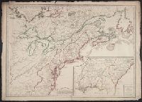
Appears in various eds. of Atlas geographicus maior., Includes German text relating to English and French territorial claims., Place names and descriptive notes in English., Prime meridian: Ferro and London., Relief shown pictorially., and Sheet measures 47.1 x 52 cm. Ms. no. on verso: No. 5. Cross Collection no. 194.
Publisher:
[Homann Erben],
Subject (Geographic):
North America--Maps--Early works to 1800 and United States--History--French and Indian War, 1755-1763--Maps--Early works to 1800
Subject (Name):
Anville, Jean Baptiste Bourguignon d', 1697-1782 and Homann Erben (Firm). Atlas geographicus maior
Appears in various eds. of Atlas geographicus maior., Includes German text relating to English and French territorial claims., Place names and descriptive notes in English., Prime meridian: Ferro and London., Relief shown pictorially., and Sheet measures 49.5 x 61.7 cm. Title in ms. on verso. Franklin Collection no. 131 1777-1.
Publisher:
[s.n.],
Subject (Geographic):
North America--Maps--Early works to 1800 and United States--History--French and Indian War, 1755-1763--Maps--Early works to 1800
Subject (Name):
Anville, Jean Baptiste Bourguignon d', 1697-1782 and Homann Erben (Firm). Atlas geographicus maior
2nd state. Distinguishing feature of 2nd state: "Title changed slightly to read 'An accurate map of the British Colonies...'" (McCorkle 111)., 755 1756F: Verso: Stamped "Oct 23 1959"., Printed text in left and right margins., and Published separately as broadsid
Publisher:
printed for and sold by H. Overton,
Subject (Geographic):
North America--Maps--Early works to 1800 and United States--History--French and Indian War, 1755-1763--Maps--Early works to 1800
"Avec Privilege ... ", 1st state. Distinguishing feature of 1st state: "Area south of Lake Erie shows Ohio River running east to west, no forts" (Pedley 212)., Also shows Indian lands., Inset map: "Supplément pour l'isle de Terre-Neuve.", and Published separatel
Publisher:
Chés l'auteur, quai de l'horloge du palais proche le pont-neuf ... ,
Subject (Geographic):
Canada--Maps--Early works to 1800, Newfoundland and Labrador--Maps--Early works to 1800, and United States--History--French and Indian War, 1755-1763--Maps--Early works to 1800
Subject (Name):
Argenson, Marc-Pierre de Voyer, comte d', 1696-1764, dedicatee
Subject (Topic):
British--America--Maps--Early works to 1800, Cartographers--France--Paris, French--America--Maps--Early works to 1800, and Indians of North America--Maps--Early works to 1800
Hand col. On sheet 54 x 73 cm. Recto: Date in title cartouche changed to "1763" in ink ms.; other annotations in ink ms.; numbered "14" in ink ms. Verso: Numbered "14" in ink ms. Labeled "Améri and Printed information matches description in Tooley.
Publisher:
Chez Mrs. Nourse, Vaillant, Millar, Rocque & autres ... Mr. Néaulme ... Mr. P. Gosse,
Subject (Geographic):
France--Colonies--America--Maps--Early works to 1800, Great Britain--Colonies--America--Maps--Early works to 1800, North America--Maps--E, and United States--History--French and Indian War, 1755-1763--Maps--Early works to 1800