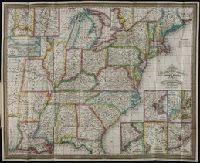
Imperfect: chipped. Autograph on verso: J.H. Chickering, Jan. 29, 1850., Includes inset maps: N. part of Michigan; N. part of Maine; Plan of Washington; S. part of Florida., Map surrounded by thirty-eight vingettes., and Prime meridian: Washington, D.C.
Atwood, John M., approximately 1818- cartographer.
Published / Created:
1849
Call Number:
71 1849
Image Count:
1
Resource Type:
Maps, Atlases & Globes
Description:
Includes 2 insets, ill., and distance table., Prime meridians: Greenwich and Washington., Relief shown by hachures and spot heights., Shows California's gold region and western trails., and Variant ed. in same year.
Publisher:
J.H. Colton,
Subject (Geographic):
California--Gold discoveries--Maps., North America--Maps., and United States--Maps.
Subject (Name):
Colton, J. H. (Joseph Hutchins), 1800-1893, publisher.
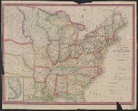
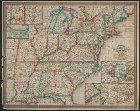
"Entered according to Act of Congress in the year 1839, by H.S. Tanner of the state of Pennsylvania.", Canals are shown in red and yellow. Railway lines shown in blue; proposed lines in green., Copy with canals, railroads colored, and borders colored., and Inclu
Publisher:
T.R. Tanner & J. Disturnell,
Subject (Geographic):
United States--Maps.
Subject (Name):
Disturnell, John, 1801-1877 and Knight, J. (Jonathan), 1787-1858
Subject (Topic):
Canals--United States--Maps. and Railroads--United States--Maps.
"Entered according to Act of Congress in the year 1839, by H.S. Tanner of the state of Pennsylvania.", Canals are shown in red and yellow. Railway lines shown in blue; proposed lines in green., Copy with canals and railroads colored., and Includes 4 canal cross
Publisher:
T.R. Tanner & J. Disturnell,
Subject (Geographic):
United States--Maps.
Subject (Name):
Disturnell, John, 1801-1877 and Knight, J. (Jonathan), 1787-1858
Subject (Topic):
Canals--United States--Maps. and Railroads--United States--Maps
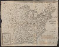
"Entered ... 1832 ...", Includes statistics, table of distances, steam boat routes, and index., Insets: New York; Boston; Charleston; Baltimore/Washington; Philadelphia; New Orleans; Cincinnati; Albany; Falls of Niagara., and Prime meridian: Washington, D.C.
Publisher:
S. Augustus Mitchell,
Subject (Geographic):
United States--Maps.
Subject (Name):
Mitchell, S. Augustus (Samuel Augustus), 1792-1868.
Mitchell’s travellers guide through the United States [cartographic material] : a map of the roads
Image Count:
1
Resource Type:
Maps, Atlases & Globes
Description:
"Entered ... 1832 ...", Includes statistics, table of distances, steam boat routes, and index., Insets: New York; Boston; Charleston; Baltimore/Washington; Philadelphia; New Orleans; Cincinnati; Albany; Falls of Niagara., and Prime meridian: Washington, D.C.
Publisher:
S. Augustus Mitchell,
Subject (Geographic):
United States--Maps.
Subject (Name):
Mitchell, S. Augustus (Samuel Augustus), 1792-1868.
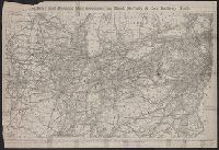
Railway and distance map accompanying Rand, McNally and Co.'s Railway Guide
Description:
Imperfect: wormholes on left edge of map, with some loss of text; lower left corner of map wanting, with some loss of text. Removed from Rand McNally and Company's railway guide (October, 1872).
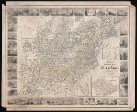
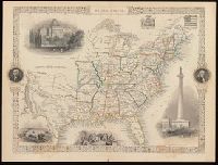
"The illustrations by J. Marchant & engraved by J. Rogers.", Probably from: The illustrated atlas, and modern history of the world, geographical, political, commercial, and statistical / Robert M. Martin. New York, [1857]., and Relief shown by hachures.
Publisher:
J. & F. Tallis,
Subject (Geographic):
United States--Maps.
Subject (Name):
John Tallis & Company, Marchant, J, and Rogers, John, approximately 1808-approximately 1888