Correspondence and drawings from students, business records and official correspondence accumulated by A.W. Smith while teaching in La Push, Neah Bay, and Mora, Washington (Territory and State). Significant correspondents include Myron Eells, Samuel G...
Description:
A.W. Smith was a teacher in the United States Indian School Service, and established a school in La Push, Washington Territory in 1882.
Subject (Geographic):
Washington (State), La Push (Wash.), Neah Bay (Wash.), and Mora (Wash.)
Subject (Name):
Smith, A.W. (Allison W.)
Subject (Topic):
Quileute Indians, Social life and customs, Makah Indians, Indians of North America, Children's art, Education, and Indian agents
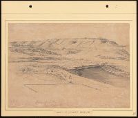
Drawings by John A. Fuller that document Sitka and other locations in Alaska, 1867, as well as a drawing of a lighthouse on Tatoosh Island, Washington, 1866-1867. Images of Sitka, Alaska, include overviews of the city and landscape, as well as several...
Description:
John A. Fuller (1828-1909) was a miner, merchant, and politician, with mining and business interests in California and Alaska. He served as a postmaster and surveyor in Sitka from 1867 to circa 1870. He later became a city councilman and mayor of Na...
Subject (Geographic):
Alaska, Sitka., Sitka (Alaska), Tatoosh Island (Wash.), Washington (State), and Wrangell Island (Wrangell-Petersburg Census Area, Alaska)
Subject (Name):
Davis, Jefferson Columbus, 1828-1879, Fuller, John A., 1828-1909., Sitka Lutheran Church (Sitka, Alaska), and St. Michael the Archangel Cathedral (Sitka, Alaska)
Subject (Topic):
Homes and haunts, Fishing lodges, Indians of North America, and Dwellings
A narrative of the life and work of Eliza Spalding Warren, the second white child born in Oregon Territory, with other facts relating to the coming of the early missionaries from 1834-38, the first printing press, the Indian tribes, the Whitman Massac...
Subject (Geographic):
Washington (State)
Subject (Name):
Eells, Edwin, 1841-1917. and Warren, Eliza Spalding, 1837-1919.
Subject (Topic):
Indians of North America, Missionaries, Nez Percé Indians, and History
Three holograph notebooks containing diary entries relating to travel; barometrical recordings; and observations on the languages and customs of the Indians and the flora and fauna of Washington Territory and the Pacific Northwest written while Gibbs...
Description:
George Gibbs, a New York lawyer, joined the Regiment of Mounted Rifles in 1849, went to Fort Vancouver, Washington, and remained in the Pacific Northwest for the next eleven years. During that time he held a number of positions, including that of an ...
Subject (Geographic):
Northwest, Pacific, Northwest, Pacific., and Washington (State)
Subject (Name):
Gibbs, George, 1815-1873. and Northwest Boundary Commission, 1857-1869.
Subject (Topic):
Pacific railroads, Explorations and surveys, Description and travel, Indians of North America, Languages, Social life and customs, Natural history, and Surveyors
Collection of approximately 76 drawings and sketches made by Brown in watercolor, oil, pastel, wash, pencil and ink. Thirty-one drawings depict army forts and western scenery, including Ringgold Barracks, Los Morus, Port Isabel, and San Jose, Texas; F...
Description:
Brown, an army surgeon and self-taught artist, served at several military posts in Texas and the Pacific Northwest in the 1850s. During the Civil War he served with the Army of the Potomac and in the Assistant Surgeon General's office in Louisville.
Subject (Geographic):
Oregon., Texas., Washington (State), Texas, Alamo (San Antonio, Tex.), Fort Dalles (Dalles, Or.), Fort Naches (Or.), Fort Ringgold (Rio Grande City, Tex.), Fort Vancouver (Wash.), Hood, Mount (Or.), Oregon, Port Isabel (Tex.), and Washington
Subject (Name):
Brown, Joseph B., 1822-1891., Lee, Robert E. 1807-1870. (Robert Edward),, and United States. Army
Subject (Topic):
Indians of North America, Wars, Missions, Spanish, Pacific Coast Indians, Wars with, 1847-1865, Military life, Voyages to the Pacific coast, and Description and travel
This collection documents the establishment and early years of the Puget Mill Company, which manufactured lumber. The bulk of the papers are letters from Josiah Keller to his partner, Charles Foster. They discuss building plans, business development, ...
Description:
Capt. Josiah P. Keller, of East Machias, Maine, was a founder of the Puget Mill Company. He sailed on the Julius Pringle from San Francisco to Puget Sound where he chose Port Gamble as a site for the mill. Keller became superintendent of the mill and ...
Subject (Geographic):
Washington (State), Port Gamble (Wash.), and Puget Sound (Wash.)
Subject (Name):
Foster, Charles, d. 1876., Keller, Josiah P., 1812-1862., Pope, Andrew J., Talbot, William C., Julius Pringle (Ship), L. P. Foster (Schooner), and Puget Mill Company.
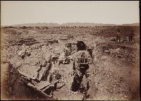
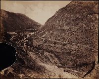
Photographs created from mammoth plate negatives primarily by photographers Carleton E. Watkins and William Henry Jackson of various locations in the American West, primarily in the states of California, Colorado, and Oregon, as well as Arizona, Monta...
Description:
A mammoth plate is a photographic negative plate, 18 by 21 inches (53.5 x 45.7 cm.) or larger, from which photographic prints are made through contact printing.
Subject (Geographic):
Wyoming, Montana, West (U.S.), Arizona, Arkansas River, Austin Bluffs (Colo.), Black Canyon of the Gunnison (Colo.), Blue Lakes (Calif.), Bridal Veil Falls (Utah), California, Cathedral Rocks (Calif.), Cathedral Spires (El Paso County, Colo.), Cathedral Spires (Jefferson County, Colo.), Clear Creek Canyon (Colo.), Clear Creek County (Colo.), Cochise Stronghold (Ariz.), Colorado, Columbia River, Costilla County (Colo.), Curecanti Needle (Colo.), Dalles (Or.), Dragoon Mountains (Ariz.), Drumlummon Mine (Mont.), Eagle Creek (Or.), Echo (Utah), El Capitan (Calif.), El Paso County (Colo.), Fountain Creek (Colo.), Fremont County (Colo.), Garden of the Gods (Colorado Springs, Colo.), Garfield County (Colo.), Gate Rock (El Paso County, Colo.), Giant Geyser (Wyo.), Glenwood Springs (Colo.), Grotto Geyser (Wyo.), Gunnison County (Colo.), Gunnison River (Colo.), Half Dome (Calif.), Jefferson County (Colo.), Jerome County (Idaho), Lake Vineyard (San Gabriel, Calif.), Marysville (Lewis and Clark County, Mont.), Mokelumne River (Calif.), Monument Park (El Paso County, Colo.), Multnomah County (Or.), Multnomah Creek (Or.), Multnomah Falls (Or.), North Cheyenne Canyon (Colo.), North Cheyenne Creek (Colo.), North Fork American River (Calif.), Old Faithful Geyser (Wyo.), Oregon, Palisades Falls, Pikes Peak (Colo.), Platte Canyon (Colo.), Port Ludlow (Wash.), Port Madison (Bainbridge Island, Wash.), Provo Canyon (Utah), Provo River (Utah), Pulpit Rock (Utah), Pulpit Terrace (Wyo.), Rainbow Falls (Colo.), Rio Arriba County (N.M.), Rio de los Pinos (Colo. and N.M.), Round Top Mountain (Calif.), Royal Gorge (Colo.), San Gabriel (Calif.), Sentinel Rock (Calif.), Seven Falls (Colo.), Sierra Blanca (Colo.), Snake River (Wyo.-Wash.), Soda Springs (Calif.), South Cheyenne Canyon (Colo.), South Cheyenne Creek (Colo.), South Platte River (Colo. and Neb.), Spokane (Wash.), Spokane River (Idaho and Wash.), Teller County (Colo.), Toltec Gorge (N.M.), Tombstone (Ariz.), Tombstone Region (Ariz.), Twin Creek (Colo.), Twin Falls (Idaho : Waterfalls), Utah, Ute Pass (Teller County, Colo.), Washington (State), Yampah Hot Springs (Colo.), Yellowstone National Park, Yosemite National Park (Calif.), and Yosemite Valley (Calif.)
Subject (Name):
Haynes, F. Jay 1853-1921. (Frank Jay),, Jackson, William Henry, 1843-1942., Meeker, Ezra, 1830-1928., Watkins, Carleton E., 1829-1916., Colorado Central Railroad Company, Denver and Rio Grande Railroad Company, Denver, South Park, and Pacific Railroad Company, Mission San Gabriel Arcangel (San Gabriel, Calif.), and Tough Nut Mine
Subject (Topic):
Geysers, Landscape photography, Mineral industries, and Railroads