Search
You Searched For
Search Results
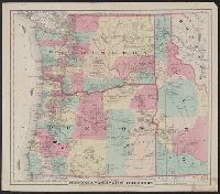
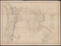
- Creator:
- G.W. & C.B. Colton & Co
- Published / Created:
- [1879?]
- Call Number:
- 846 1879B
- Container / Volume:
- BRBL_00621
- Image Count:
- 1
- Resource Type:
- Maps, Atlases & Globes
- Alternative Title:
- Colton's map of Oregon and Washington Territory and Map of Oregon & Washington Territory
- Description:
- "Entered according to act of Congress in the year 1879 by G.W. & C.B. Colton & Co. ...."
- Publisher:
- G.W. & C.B. Colton & Co.,
- Subject (Geographic):
- Oregon--Maps and Washington (State)--Maps
- Subject (Name):
- Oregon State Board of Immigration
- Found in:
- Beinecke Rare Book and Manuscript Library > Colton's map of Oregon & Washington Territory / issued by the Oregon State Board of Immigration ; prepared by G.W. & C.B. Colton & Co.
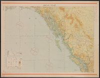
- Published / Created:
- Shōwa 18 [1943] and 昭和 18 [1943]
- Call Number:
- 739CBF 1945 1
- Container / Volume:
- BRBL_00391
- Image Count:
- 1
- Resource Type:
- Maps, Atlases & Globes
- Alternative Title:
- Japan. 陸地測量部., Japan. 陸軍. 参謀本部., and ジュノー--シヤトル / 陸地測量部, 参謀本部.
- Description:
- "Kōkūzu gunji himitsu (senchi ni arite wa 'bugaihi' to su) "
- Publisher:
- s.n.],
- Subject (Geographic):
- Alaska--Maps, British Columbia--Maps, and Washington (State)--Maps
- Subject (Name):
- Japan. Rikuchi Sokuryōbu and Japan. Rikugun. Sanbō Honbu
- Subject (Topic):
- Aeronautical charts--Alaska, Aeronautical charts--British Columbia, and Aeronautical charts--Washington (State)
- Found in:
- Beinecke Rare Book and Manuscript Library > Junō--Shiyatoru / Rikuchi Sokuryōbu, Sanbō Honbu.
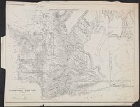
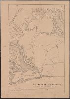
- Creator:
- United States. Surveyor General
- Published / Created:
- 1860
- Call Number:
- 847 1861
- Container / Volume:
- BRBL_00625
- Image Count:
- 1
- Resource Type:
- Maps, Atlases & Globes
- Alternative Title:
- Sen. ex. doc. ; no. 1, 2nd session, 36th Congress and Senate executive document (United States. Congress. Senate) ; 36th Congress, 2nd session, no. 1.
- Description:
- Relief shown by hachures.
- Publisher:
- s.n.],
- Subject (Geographic):
- Washington (State)--Maps
- Subject (Name):
- Bien, Julius, 1826-1909 and Tilton, James
- Found in:
- Beinecke Rare Book and Manuscript Library > Map of a part of Washington Territory : to accompany the report of the Surveyor General, 1860-61.
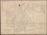
- Creator:
- Washington (State). Surveyor General's Office
- Published / Created:
- 1859
- Call Number:
- 847 1859A
- Container / Volume:
- BRBL_00625
- Image Count:
- 1
- Resource Type:
- Maps, Atlases & Globes
- Alternative Title:
- Senate executive document (United States. Congress. Senate) ; 36th Congress, 1st session, no. 2.
- Description:
- "Sen. Ex. Doc. No. 2, 1st session 36th Congress."
- Publisher:
- Surveyor General's Office?],
- Subject (Geographic):
- Washington (State)--Maps
- Subject (Name):
- Bien, Julius, 1826-1909
- Found in:
- Beinecke Rare Book and Manuscript Library > Map of a part of Washington Territory : to accompany the report of the Surveyor General.
- Creator:
- Tilton, James
- Published / Created:
- 1857
- Call Number:
- 847 1857
- Container / Volume:
- BRBL_00625
- Image Count:
- 1
- Resource Type:
- Maps, Atlases & Globes
- Description:
- "Surveyor General's Office, Olympia, W.T., September 21st 1857. James Tilton [signature], Surveyor General."
- Publisher:
- General Land Office?],
- Subject (Geographic):
- Washington (State)--Maps
- Subject (Name):
- Graham, C. B. (Curtis B.) and Washington (State). Surveyor General's Office
- Found in:
- Beinecke Rare Book and Manuscript Library > Map of a part of Washington Territory lying east of the Cascade Mountains : to accompany report of Surveyor General.
- Creator:
- United States. Surveyor General
- Published / Created:
- 1855
- Call Number:
- 847 1855A
- Container / Volume:
- BRBL_00625
- Image Count:
- 1
- Resource Type:
- Maps, Atlases & Globes
- Alternative Title:
- Sen. ex. doc. ; no. 1, 1st session, 34th Congress and Senate executive document (United States. Congress. Senate) ; 34th Congress, 1st session, no. 1.
- Description:
- "James Tilton, Surveyor General."
- Publisher:
- Surveyor General's Office,
- Subject (Geographic):
- Washington (State)--Maps
- Subject (Name):
- Tilton, James
- Found in:
- Beinecke Rare Book and Manuscript Library > Map of a part of the territory of Washington : to accompany report of Surveyor General, 1855.
- Creator:
- Eastwick, Morris & Co
- Published / Created:
- 1878
- Call Number:
- 847 1878
- Container / Volume:
- BRBL_00625
- Image Count:
- 1
- Resource Type:
- Maps, Atlases & Globes
- Publisher:
- Eastwick, Morris & Co.,
- Subject (Geographic):
- Washington (State)--Maps
- Found in:
- Beinecke Rare Book and Manuscript Library > Map of south eastern Washington Territory / compiled from official surveys and published by Eastwick, Morris & Co. ; drawn by John Hanson.
- Creator:
- Poole Brothers
- Published / Created:
- c1898.
- Call Number:
- 846gme 1898
- Container / Volume:
- BRBL_00624
- Image Count:
- 1
- Resource Type:
- Maps, Atlases & Globes
- Abstract:
- Shows railroads and steamship routes in Washington, Oregon, and part of Idaho.
- Description:
- Copyright: Poole Bros., Chicago.
- Publisher:
- Poole Bros.?],
- Subject (Geographic):
- Oregon--Maps and Washington (State)--Maps
- Subject (Name):
- Oregon Railroad and Navigation Company and Oregon Railroad and Navigation Company--Maps
- Subject (Topic):
- Railroads--Idaho--Maps, Railroads--Oregon--Maps, and Railroads--Washington (State)--Maps
- Found in:
- Beinecke Rare Book and Manuscript Library > Map of the Oregon Railroad and Navigation Co.
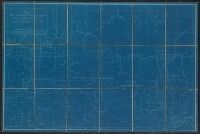
- Creator:
- Glümer, J. v
- Published / Created:
- 1883?]
- Call Number:
- 847 1883
- Container / Volume:
- BRBL_00625
- Image Count:
- 1
- Resource Type:
- Maps, Atlases & Globes
- Description:
- Blueprint.
- Publisher:
- s.n.,
- Subject (Geographic):
- Canada--Boundaries--United States--Maps, United States--Boundaries--Canada--Maps, and Washington (State)--Maps
- Subject (Name):
- Poe, O. M. (Orlando Metcalfe), 1832-1895
- Found in:
- Beinecke Rare Book and Manuscript Library > Map of the n.w. boundaries of the United States / compiled in 1883 under the direction of Bvt. Brig. Gen'l. O.M. Poe, U.S. Army Lt. Col. of Engineers, Col. & A.D.C. ; compiled & drawn by J. von Glümer.
- Creator:
- United States. Army. Corps of Topographical Engineers
- Published / Created:
- 1859
- Call Number:
- 846 1859
- Container / Volume:
- BRBL_00620
- Image Count:
- 1
- Resource Type:
- Maps, Atlases & Globes
- Description:
- At head of title: Department of Oregon.
- Publisher:
- The Bureau],
- Subject (Geographic):
- Northwest, Pacific--Maps, Oregon--Maps, and Washington (State)--Maps
- Subject (Name):
- Dougal, William H., 1822-1895, Floyd, John B. (John Buchanan), 1806-1863, and United States. Army. Dept. of Oregon
- Found in:
- Beinecke Rare Book and Manuscript Library > Map of the state of Oregon and Washington Territory / compiled in the Bureau of Topogrl. Engrs. chiefly for military purposes, by order of John B. Floyd ; engraved by W.H. Dougal.