Search
You Searched For
Search Results
- Published / Created:
- 1803
- Call Number:
- 85 1803C
- Container / Volume:
- BRBL_00637
- Image Count:
- 1
- Resource Type:
- Maps, Atlases & Globes
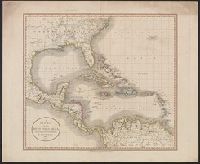
- Description:
- By John Cary, Engraver.
- Subject (Geographic):
- West Indies--Maps
- Found in:
- Beinecke Rare Book and Manuscript Library > A New MAp of the West India Isles, from the latest authorities.
- Published / Created:
- 1827
- Call Number:
- 85cea 1842
- Container / Volume:
- BRBL_00639
- Image Count:
- 1
- Resource Type:
- Maps, Atlases & Globes
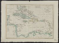
- Description:
- Eng. by J. Stephenson.
- Publisher:
- J.W. Norie & Co.,
- Subject (Geographic):
- West Indies--Maps
- Found in:
- Beinecke Rare Book and Manuscript Library > A new chart of the Caribbean Isles ... from Porto Rico to Trinidad ...
- Published / Created:
- 1814
- Call Number:
- 85 1814
- Container / Volume:
- BRBL_00638
- Image Count:
- 1
- Resource Type:
- Maps, Atlases & Globes
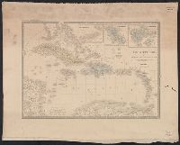
- Description:
- Borders are hand colored according to European possession.
- Publisher:
- Im Verlage des Geograph. Instituts,
- Subject (Geographic):
- West Indies--Maps
- Subject (Name):
- Geographisches Institut (Weimar, Thuringia, Germany)
- Found in:
- Beinecke Rare Book and Manuscript Library > Charte von West Indien oder den Antillischen Inseln.
- Creator:
- G.W. & C.B. Colton & Co
- Published / Created:
- 1864
- Call Number:
- 75 1864
- Container / Volume:
- BRBL_00403
- Image Count:
- 1
- Resource Type:
- Maps, Atlases & Globes
- Alternative Title:
- Railroad and military map of the United States, Mexico, the West Indies &c.
- Description:
- In upper left margin: No. 7.
- Publisher:
- J.H. Colton,
- Subject (Geographic):
- Central America--Maps, Mexico--Maps, United States--Maps, and West Indies--Maps
- Subject (Topic):
- Military bases--United States--Maps and Railroads--United States--Maps
- Found in:
- Beinecke Rare Book and Manuscript Library > Coltons' rail-road and military map of the United States, Mexico, the West Indies &c.
- Published / Created:
- [1830?]
- Call Number:
- 85 1830
- Container / Volume:
- BRBL_00638
- Image Count:
- 1
- Resource Type:
- Maps, Atlases & Globes
- Publisher:
- Institut Geographique,
- Subject (Geographic):
- West Indies--Maps
- Found in:
- Beinecke Rare Book and Manuscript Library > Iles Antilles ou Indies Occidentales. Dresée par Brué ...
- Creator:
- Johnson, A. J. (Alvin Jewett), 1827-1884
- Published / Created:
- 1864
- Call Number:
- 85 1866
- Container / Volume:
- BRBL_00638
- Image Count:
- 2
- Resource Type:
- Maps, Atlases & Globes
- Alternative Title:
- Geography of South America
- Description:
- Inset: The Bermuda Islands.
- Publisher:
- Johnson and Ward,
- Subject (Geographic):
- Bermuda Islands--Maps and West Indies--Maps
- Found in:
- Beinecke Rare Book and Manuscript Library > Johnson's West Indies.
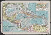
- Creator:
- American Bank Note Company
- Published / Created:
- c1913.
- Call Number:
- 85 1913
- Container / Volume:
- BRBL_00638
- Image Count:
- 1
- Resource Type:
- Maps, Atlases & Globes
- Alternative Title:
- National Geographic magazine map of Central America, Cuba, Porto Rico, and the islands of the Caribbean Sea
- Description:
- "Copyright ... by American Bank Note Company, New York."
- Publisher:
- National Geographic Magazine,
- Subject (Geographic):
- Caribbean Area--Maps, Central America--Maps, and West Indies--Maps
- Subject (Name):
- National Geographic Society (U.S.)
- Found in:
- Beinecke Rare Book and Manuscript Library > Map of Central America, Cuba, Porto Rico, and the islands of the Caribbean Sea / prepared by the American Bank Note Co. ; Gilbert H. Grosvenor, editor.
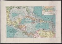
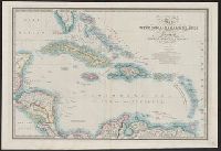
- Creator:
- Wyld, James, 1812-1887
- Published / Created:
- 1872
- Call Number:
- 85 1872
- Container / Volume:
- BRBL_00638
- Image Count:
- 1
- Resource Type:
- Maps, Atlases & Globes
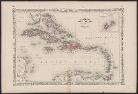
- Alternative Title:
- West India & Bahama islands.
- Description:
- Includes: Possessions of the European powers.
- Publisher:
- Published by James Wyld ...,
- Subject (Geographic):
- West Indies--Maps
- Found in:
- Beinecke Rare Book and Manuscript Library > Map of the West India & Bahama islands, with the adjacent coasts of Yucatan, Honduras, Caracas, &c.
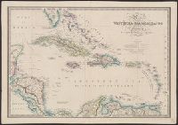
- Creator:
- Wyld, James, 1812-1887
- Published / Created:
- 1851
- Call Number:
- 85 1851
- Container / Volume:
- BRBL_00638
- Image Count:
- 1
- Resource Type:
- Maps, Atlases & Globes
- Alternative Title:
- West India & Bahama islands.
- Description:
- Includes: Possessions of the European powers.
- Publisher:
- Published by James Wyld ...,
- Subject (Geographic):
- West Indies--Maps
- Found in:
- Beinecke Rare Book and Manuscript Library > Map of the West India & Bahama islands, with the adjacent coasts of Yucatan, Honduras, Caracas, &c.