Skip to search
Skip to main content
Skip to first result
Yale University Library
Saved Items
Access Requests
Ask Yale Library
Reserve Rooms
Places to Study
Research
Search Quicksearch
Search Library Catalog
Search Digital Collections
Search Archives at Yale
Research Guides
Find Databases by Title
Find eJournals by Title
Guide to Using Special Collections
Services
Request Digital Copies of Special Collections
Your Personal Librarian
Subject Specialists
Research Support and Workshops
Citation Tools
Get It @ Yale (Borrow Direct, Interlibrary Loan, Scan & Deliver)
Course Reserves
Off-Campus Access
EliScholar
OverDrive: Popular Audio and eBooks
Bass Media Equipment
Libraries & Collections
Arts Library
Bass Library
Beinecke Library
Classics Library
Divinity Library
Yale Film Archive
Fortunoff Archive
Humanities Collections
International Collections
Law Library
Lewis Walpole Library
Library Collection Services
Manuscripts & Archives
Map Collection
Marx Science & Social Science Library
Medical Library
Music Library
Sterling Library
Yale Center for British Art
Information & Policies
Library Hours
Departments & Staff
Borrowing & Circulation
Services for Persons with Disabilities
Copyright Basics
Scanning, Printing & Copying
Computers & Wireless
Library Policies
About the Library
Giving to the Library
Purchase Request
Working at the Library
Terms Governing Use of Materials
Search in
All Fields
Creator
Title
Call Number
Date
Subject
Orbis ID
Full Text
Description
Full text
search for
Search
Search
Advanced Search
Digital Collections
Search
You Searched For
Subject Heading
Artois (France) > Maps
New Search
1
-
2
of
2
Sort
by Relevance
Relevance
Creator (A --> Z)
Creator (Z --> A)
Title (A --> Z)
Title (Z --> A)
Year (ascending)
Year (descending)
Number of results to display per page
9
per page
9
per page
30
per page
60
per page
99
per page
View results as:
List
List
Gallery
Gallery
Search Results
1.
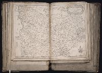
Carte generale de Picardie et Artois [cartographic material].
Creator:
Tassin, Christophe
Published / Created:
1634]
Call Number:
1983 Folio 19
Image Count:
1
Description:
BEIN 1983 Folio 19: Imperfect: tear in upper left corner, repaired with no loss of text. Reinforced along lower edges with manuscript waste. Sheet measures 38.2 x 51.5 cm. No. 35 of 92 maps bound together.
Publisher:
Christophe Tassin
Subject (Geographic):
Picardy (France) and Artois (France)
Found in:
Beinecke Rare Book and Manuscript Library
>
Carte generale de Picardie et Artois [cartographic material].
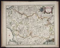
2.
Geographica Artesiae comitatus tabula [cartographic material]
Creator:
Visscher, Nicolaes, 1649-1702, cartographer
Published / Created:
ca. 1684]
Call Number:
Folio 469
Image Count:
1
Description:
BEIN Folio 469: Sheet measures 52.6 x 60.6 cm. No. 10 of 13 maps bound together with binder's title: Sanson.
Publisher:
Nicolaes Visscher
Subject (Geographic):
Artois (France) and Pas-de-Calais (France)
Found in:
Beinecke Rare Book and Manuscript Library
>
Geographica Artesiae comitatus tabula [cartographic material]
Limit your search
Extent of Digitization
Completely digitized
2
Access
Public
2
Repository
Beinecke Rare Book and Manuscript Library
2
Genre
Early works to 1800
2
Maps
2
Manuscript waste (Binding)
1
Language
French
1
Latin
1
Creator
Tassin, Christophe
1
Visscher, Nicolaes, 1649-1702, cartographer
1
Publication Place
Amsterdam
1
Netherlands Amsterdam
1
Paris
1
Date Created
View distribution
Current results range from
1634
to
1684
Date Created range begin
Date Created range end
View larger »