Skip to search
Skip to main content
Skip to first result
Search
You Searched For
Subject Heading
Baden-Württemberg (Germany) > Maps
Search Results
Creator:
Published / Created:
ca. 1743.
Call Number:
1983 Folio 23
Image Count:
1
Alternative Title:
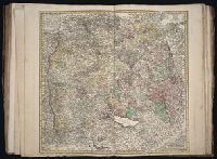
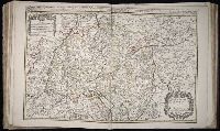
Circvli Sveviae mappa, Cercle de Suabe, and Cercle de Svabe
Description:
BEIN 1983 Folio 23: Imperfect: torn along fold, with some loss of text. Sheet measures 54.4 x 64.4 cm. No. 37 of 50 maps bound together.
Publisher:
Homann Erben
Subject (Geographic):
Baden-Württemberg (Germany)
Found in:
Beinecke Rare Book and Manuscript Library > Circuli Sueviae mappa
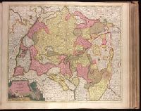
Creator:
Published / Created:
[ca. 1702?]
Call Number:
1973 Folio 18
Image Count:
1
Description:
BEIN 1973 Folio 18: Backed with paper. Ms. no. "28" in upper left-hand corner. Sheet measures 53.7 x 63.0 cm. No. 28 of 87 maps bound together.
Publisher:
Edente Gerardô Valck
Subject (Geographic):
Baden-Württemberg (Germany)
Subject (Topic):
Maps
Found in:
Beinecke Rare Book and Manuscript Library > Circulus Suevicus complectens omnes status subdivisos ex quibus constat [cartographic material].
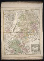
Creator:
Published / Created:
1786.
Call Number:
1983 Folio 23
Image Count:
1
Alternative Title:
Carte geographique du Cercle de Haut-Rhin
Description:
BEIN 1983 Folio 23: Sheet measures 63.7 x 54.5 cm. No. 38 of 50 maps bound together.
Publisher:
Bey denen Homännischen Erben
Subject (Geographic):
Baden-Württemberg (Germany), Hesse (Germany), North Rhine-Westphalia (Germany), and Rhineland-Palatinate (Germany)
Found in:
Beinecke Rare Book and Manuscript Library > Der Ober Rheinische Kreis : nach seinen Unterabtheilungen, entworfen von F.L. Güssefeld
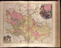
Creator:
Published / Created:
[between 1690 and 1696?]
Call Number:
1973 Folio 18
Image Count:
1
Resource Type:
cartographic image
Description:
BEIN 1977 Folio 191: Imperfect: slight tears, repaired with paper on verso, with no loss of text. Sheet measures 52.8 x 61.3 cm. No. 31 of 52 maps bound together.
Publisher:
Theodore Danckerts
Subject (Geographic):
Lorraine (France), Alsace (France), Saarland (Germany), and Baden-Württemberg (Germany)
Found in:
Beinecke Rare Book and Manuscript Library > Lotharingiae et Utriusque Alsatiae in ditiones minores divisarum tractibusque insertis et finitimis circumscriptarum novissima, nitidissima et accuratissima delineatio
Creator:
Published / Created:
ca. 1700?]
Call Number:
1973 Folio 18
Image Count:
1
Description:
BEIN 1973 Folio 18: Backed with paper. Ms. no. "33" in upper-right corner. Sheet measures 53.5 x 62.7 cm. No. 32 of 87 maps bound together.
Publisher:
Peter Schenk
Subject (Geographic):
Rhineland-Palatinate (Germany), Hesse (Germany), and Baden-Württemberg (Germany)
Found in:
Beinecke Rare Book and Manuscript Library > Palatinatus Rheni tabula exquisitissima : cui quoque subjacentes ac finitimae Dominatus, Ditiones atque Satrapias
Creator:
Published / Created:
ca. 1700?]
Call Number:
1973 Folio 18
Image Count:
1
Description:
BEIN 1973 Folio 18: Backed with paper. Ms. no. "32" in lower-right corner. Sheet measures 62.3 x 53.6 cm. No. 31 of 87 maps bound together.
Publisher:
Peter Schenk
Subject (Geographic):
Alsace (France), Saarland (Germany), and Baden-Württemberg (Germany)
Subject (Topic):
Maps
Found in:
Beinecke Rare Book and Manuscript Library > Superioris atque inferioris Alsatiae tabula perquam accurata et exacta proximis regionibus Iucunde huic insertis, annexisque / [cartographic material]
Creator:
Published / Created:
[ca. 1686]
Call Number:
1973 Folio 10
Image Count:
1
Alternative Title:
Circle of Bavaria, or the bishopricks of Augsbourg, and of Constance, the Abbaies of Kempten, Buchaw, Lindaw ... described by Sanson, corrected and amended by William Berry
Description:
BEIN 1973 Folio 10: Sheet measures 60.8 x 96.5 cm. Bookplate of José M. Rodriguez. No. 31 of 63 maps bound together.
Publisher:
Sold by William Berry at the signe of the Globe between Charing Cross, and White-Hall
Subject (Geographic):
Bavaria (Germany), Swabia (Germany), and Baden-Württemberg (Germany)
Found in:
Beinecke Rare Book and Manuscript Library > The circle of Swabia subdivided into all the territories it's composed of.