Skip to search
Skip to main content
Skip to first result
Search
You Searched For
Subject Heading
Baltic States > Maps > Early works to 1800
Search Results
Creator:
Published / Created:
October 10th, 1788.
Call Number:
1982 Folio 10
Image Count:
1
Description:
BEIN 1982 Folio 10: Armorial bookplate: Charles Abbot. No. 23 of 42 maps bound together.
Publisher:
Printed for Robert Sayer
Subject (Geographic):
Scandinavia, Russia, and Baltic States
Found in:
Beinecke Rare Book and Manuscript Library > A new map of the Northern States containing the Kingdoms of Sweden, Denmark, and Norway, with the western parts of Russia, Livonia, Courland &ca.
Creator:
Published / Created:
1739.
Call Number:
1975 Folio 31
Image Count:
1
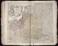
Description:
BEIN 1975 Folio 31: Imperfect: edges frayed, torn along fold, and torn on lower right, with some loss of text. Sheet measures 53.4 x 61.9 cm. No. 32 of 42 maps bound together.
Publisher:
Homann Erben
Subject (Geographic):
Baltic States and Poland
Found in:
Beinecke Rare Book and Manuscript Library > Regni Poloniae magnique Ducatus Lithuaniae
Creator:
Published / Created:
171-?]
Call Number:
1973 Folio 18
Image Count:
1
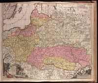
Description:
BEIN 1973 Folio 18: Backed with paper. Sheet measures 53.8 x 62.3 cm. No. 79 of 87 maps bound together.
Publisher:
Gerard van Keulen
Subject (Geographic):
Baltic States, Poland, and Ukraine
Subject (Topic):
Maps
Found in:
Beinecke Rare Book and Manuscript Library > Regni Poloniae magnique Ducatus Lithuaniae, Volhyniae, Podoliae, Ucraniae, Prussiae, Livoniae exactissima descriptio [cartographic material]
Creator:
Published / Created:
ca. 1710]
Call Number:
1983 Folio 23
Image Count:
1
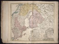
Description:
BEIN 1983 Folio 23: Sheet measures 54.5 x 64.2 cm. No. 5 of 50 maps bound together.
Publisher:
Johann Baptist Homann
Subject (Geographic):
Sweden, Finland, and Baltic States
Found in:
Beinecke Rare Book and Manuscript Library > Regni Sueciae in omnes suas subjacentes provincias accurate divisi tabula generalis
Creator:
Published / Created:
ca. 1702?]
Call Number:
1973 Folio 18
Image Count:
1
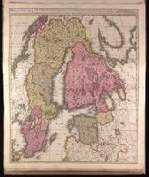
Description:
BEIN 1973 Folio 18: Backed with paper. Ms. no. "5" in upper left-hand corner. Sheet measures 62.8 x 53.4 cm. No. 4 of 87 maps bound together.
Publisher:
Gerard Valck
Subject (Geographic):
Scandinavia and Baltic States
Found in:
Beinecke Rare Book and Manuscript Library > Sueciae magnae, totius orbis regni antiquissimi, hodierna in sex principales suas partes : Gothiam nempe, Sueciam propriam sive stricté sumptam, Nordlandiam, Finniam, Ingriam, Livoniam earundemq[ue] subdivisionum, ac adjacentium insularum geographica distinctio