Skip to search
Skip to main content
Skip to first result
Search
You Searched For
Subject Heading
Caribbean Area > Maps > Early works to 1800
Search Results
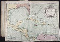
Creator:
Published / Created:
1755.
Call Number:
2003 Folio 85
Image Count:
1
Description:
BEIN 2003 Folio 85: No. 27 of 45 maps bound together with binder's spine title: Atlas of America; ms. table of contents. Bookplate: Robinson. Bookplate of Paul Mellon.
Subject (Geographic):
Caribbean Area
Subject (Topic):
Nautical charts
Found in:
Beinecke Rare Book and Manuscript Library > Mapa maritimo del Golfo de Mexico e islas de la America : para el uso de los navegantes en esta parte del mundo, construido sobre las mexores memorias, y observaciones astronomicas de longitudes, y latitudes
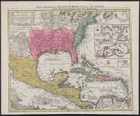
Creator:
Published / Created:
[between 1741 and 1760]
Call Number:
71 1737A
Image Count:
1
Resource Type:
cartographic image
Description:
BEIN 85 1740D: Stamp on verso: Yale, Horace Brown, 1900S.
Publisher:
Tobias Conrad Seutter
Subject (Geographic):
North America, United States, Mexico, Central America, and Caribbean Area
Found in:
Beinecke Rare Book and Manuscript Library > Mappa geographica regionem Mexicanam et Floridam terrasque adjacentes, ut et anteriores Americae insulas, cursus itidem et reditus navigantium versus flumen Missisipi et alias colonias ob oculos ponens / [cartographic material]
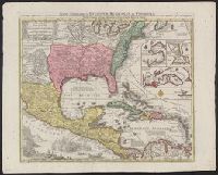
Creator:
Published / Created:
[between 1741 and 1760]
Call Number:
85 1740D
Image Count:
1
Resource Type:
cartographic image
Description:
BEIN 85 1740D: Stamp on verso: Yale, Horace Brown, 1900S.
Publisher:
Tobias Conrad Seutter
Subject (Geographic):
North America, United States, Mexico, Central America, and Caribbean Area
Found in:
Beinecke Rare Book and Manuscript Library > Mappa geographica regionem Mexicanam et Floridam terrasque adjacentes, ut et anteriores Americae insulas, cursus itidem et reditus navigantium versus flumen Missisipi et alias colonias ob oculos ponens / [cartographic material]
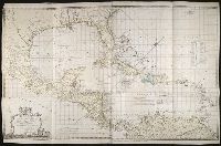
Creator:
Published / Created:
May 20th, 1774.
Call Number:
1982 Folio 10
Image Count:
1
Alternative Title:
Chart of the West Indies
Description:
BEIN 85 1774A: Sheet measures 75 x 118.2 cm.
Publisher:
Capt. Speer
Subject (Geographic):
Caribbean Area and West Indies
Found in:
Beinecke Rare Book and Manuscript Library > To His Royal Highness. George Augustus Frederick. Prince of Wales &c. &c. &c. this chart of the West Indies is humbly inscribed by His Royal Highness faithful & obedient servant Joseph Smith Speer, Thos. Bowen sculpt