Skip to search
Skip to main content
Skip to first result
Search
You Searched For
Subject Heading
Coasts
Search Results
Creator:
Published / Created:
1766. NB. With a book of directions.
Call Number:
2003 Folio 85
Image Count:
1
Description:
BEIN 2003 Folio 85: Without book of directions mentioned after publisher statement. No. 10 of 45 maps bound together with binder's spine title: Atlas of America; ms. table of contents. Bookplate: Robinson. Bookplate of Paul Mellon.
Publisher:
Published ... by James Cook, and sold by I. Mount and T. Page ... Tho's. Jeffrey ... and And'w. Dury ... London
Subject (Geographic):
Newfoundland and Labrador
Subject (Topic):
Coasts and Nautical charts
Found in:
Beinecke Rare Book and Manuscript Library > A chart of part of the south coast of Newfoundland : including the islands St. Peters and Miquelon : from an actual survey taken by order of Commodore Pallisser, Governor of Newfoundland, Labrador, &c.
Creator:
Published / Created:
June 17th, 1780.
Call Number:
1982 Folio 10
Image Count:
1
Description:
BEIN 1982 Folio 10: Armorial bookplate: Charles Abbot. No. 8 of 42 maps bound together.
Publisher:
Engraved & published by W. Faden
Subject (Geographic):
North Sea, English Channel, France, England, and Biscay, Bay of (France and Spain)
Subject (Topic):
Nautical charts, Coasts, and Navigation
Found in:
Beinecke Rare Book and Manuscript Library > A chart of the British Channel and the Bay of Biscay with a part of the North Sea, and the entrance of St. George's Channel
Creator:
Published / Created:
June 28th, 1780.
Call Number:
1982 Folio 10
Image Count:
1
Description:
BEIN 1982 Folio 10: Armorial bookplate: Charles Abbot. No. 13 of 42 maps bound together.
Publisher:
Engraved & published by Wm. Faden
Subject (Geographic):
Spain, Portugal, Africa, North, and Mediterranean Sea
Subject (Topic):
Nautical charts and Coasts
Found in:
Beinecke Rare Book and Manuscript Library > A chart of the coasts of Spain and Portugal, with the Balearic Islands, and part of the coast of Barbary
Creator:
Published / Created:
Jany. 1st, 1781.
Call Number:
1982 Folio 10
Image Count:
1
Description:
BEIN 1982 Folio 10: Armorial bookplate: Charles Abbot. No. 9 of 42 maps bound together.
Publisher:
W. Faden
Subject (Geographic):
Channel Islands, France, Brittany, Normandy, Brittany (France), and Normandy (France)
Subject (Topic):
Nautical charts and Coasts
Found in:
Beinecke Rare Book and Manuscript Library > A chart of the islands of Jersey and Guernsey, Sark, Herm and Alderney, with the adjacent coast of France
Creator:
Published / Created:
Decem'r. 1766.
Call Number:
2003 Folio 85
Image Count:
1
Description:
BEIN 2003 Folio 85: No. 15 of 45 maps bound together with binder's spine title: Atlas of America; ms. table of contents. Bookplate: Robinson. Bookplate of Paul Mellon.
Publisher:
Published by the author according to Act of Parliament
Subject (Geographic):
Nova Scotia and Halifax (N.S.)
Subject (Topic):
Coasts and Nautical charts
Found in:
Beinecke Rare Book and Manuscript Library > A draught of the harbour of Halifax and the adjacent coast in Nova Scotia : surveyed by order of Commodore Spry
Creator:
Published / Created:
December 1766.
Call Number:
2003 Folio 85
Image Count:
1
Description:
BEIN 2003 Folio 85: No. 26 of 45 maps bound together with binder's spine title: Atlas of America; ms. table of contents. Bookplate: Robinson. Bookplate of Paul Mellon.
Publisher:
Published by the author according to Act of Parliament
Subject (Geographic):
Florida
Subject (Topic):
Coasts and Nautical charts
Found in:
Beinecke Rare Book and Manuscript Library > A draught of west Florida : with part of the river Mississippi
Creator:
Published / Created:
[169-?]
Call Number:
1973 Folio 10
Image Count:
1
Description:
BEIN 1973 Folio 10: Sheet measures 61.2 x 52 cm. Bookplate of José M. Rodriguez. No. 6 of 63 maps bound together.
Publisher:
Printed and sold by Chr. Brown at the Globe in St. Pauls Church Yard
Subject (Geographic):
France, Northern, English Channel, and England, Southern
Subject (Topic):
Coasts
Found in:
Beinecke Rare Book and Manuscript Library > A new chart of the sea coasts of France : together with the English Chanell describing ye severall harbors, sands, rocks, and anchoridges &c. on the said coasts
Creator:
Published / Created:
[ca. 1700]
Call Number:
1973 Folio 10
Image Count:
1
Alternative Title:
New map of the sea coasts of England, Scotland, and Ireland
Description:
BEIN 1973 Folio 10: Sheet measures 52 x 61.2 cm. Bookplate of José M. Rodriguez. No. 3 of 63 maps bound together.
Publisher:
Sold by Robert Morden at the Atlas in Cornhill and by Christopher Brown at the Globe in St. Paul's Church Yard
Subject (Geographic):
Great Britain and North Sea
Subject (Topic):
Coasts
Found in:
Beinecke Rare Book and Manuscript Library > A new mapp of the sea coasts of England, Scotland, and Ireland : with the adjacent coasts of France, Holand, Denmark & Norway, shewing the scituation and distance of the several ports, harbors, havens, creeks, sands &c.
Creator:
Published / Created:
ca. 1763]
Call Number:
2003 Folio 85
Image Count:
1
Description:
BEIN 2003 Folio 85: No. 11 of 45 maps bound together with binder's spine title: Atlas of America; ms. table of contents. Bookplate: Robinson. Bookplate of Paul Mellon.
Publisher:
s.n
Subject (Geographic):
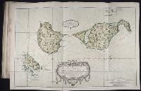
Saint Pierre and Miquelon
Subject (Topic):
Coasts and Nautical charts
Found in:
Beinecke Rare Book and Manuscript Library > Carte des isles de Saint Pierre et Miquelon : levée par ordre de M. Le Duc du Choiseul, Colonel Général des Suisses et Grisons Ministre de la Guerre et de la Marine, 1763 : reduite et assujetie au ciel par le service des vaisseaux du Roy
Call Number:
OSB MSS 155
Container / Volume:
Box
Image Count:
30
Abstract:
Manuscript documents and letters, illustrating the daily life and responsibilities of sea captains in the 18th and early 19th centuries. The collection includes documents relating to Captain Robert Poultney in Jamaica and letters on personal and naval...
Description:
Robert Poultney was the captain of the ship Loretta in Jamaica in 1762-1764.
Subject (Geographic):
Mediterranean Region and Brittany (France)
Subject (Name):
Poultney, Robert., Wainwright, John, Captain., Chiffonne (Ship), Great Britain. Royal Navy, and Loretta (Ship)
Subject (Topic):
Officers, Sea life, Aids to navigation, Coasts, Navigation, Seafaring life, Ship captains, and Description and travel
Found in:
Beinecke Rare Book and Manuscript Library > Documents concerning ship captains and shipping, 1762-circa 1809