
- None19
You Searched For
« Previous
| 1 - 9 of 19 |
Next »
Search Results

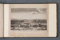
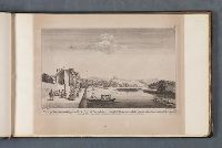
1. A general view of the city of London, next the River Thames Vüe générale de la ville de Londres qui comprend la partie la plus voisine de la Tamise. [graphic] =
- Published / Created:
- [between 1751 and 1770]
- Call Number:
- Folio 75 L847 750
- Collection Title:
- Leaf 20. London and its environs about 1750.
- Image Count:
- 1
- Resource Type:
- still image
- Abstract:
- "Bird's eye view of London; the Tower on the right, old London Bridge in the centre with the Monument to its right, St Paul's beyond, Westminster Abbey in the distance at the left; a reduced copy of a print by Bowles."--British Museum online catalogue
- Alternative Title:
- Vüe générale de la ville de Londres qui comprend la partie la plus voisine de la Tamise
- Description:
- Titles etched below image, in English and French., Probably a later state, with slight alterations to the plate numbering. For a state with "No. 1" in upper right corner and no number in upper left corner, see British Museum online catalogue, registration no.: 1875,0710.4904., Date range for publication from the British Museum online catalogue., Plate reissued by Sayer and Bennett and listed in their 1775 catalogue as part of the series "Twelve views of the city of London and public buildings therein, accurately engraved from the originals taken on the spot", in the section on "Sets of small prints"; see: Sayer and Bennett's enlarged catalogue of new and valuable prints. London : [Sayer and Bennett], 1775, page 86, no. 8., Plate numbered "No. 1" in upper left corner and "1" in upper right corner., Watermark: Curteis & Son 1806., and Leaf 20 in an album of views of London and its vicinity.
- Publisher:
- Printed for Robt. Sayer, map & printseller, at the Golden Buck near Serjeants Inn, Fleet Street
- Subject (Geographic):
- London (England), Thames River (England),, London Bridge (London, England),, England, and London.
- Subject (Name):
- Tower of London (London, England),, St. Paul's Cathedral (London, England),, and Westminster Abbey,
- Subject (Topic):
- Monument, The (London, England), Cathedrals, Bridges, Monuments & memorials, Rivers, Boats, and Sailing ships
- Found in:
- Lewis Walpole Library > A general view of the city of London, next the River Thames Vüe générale de la ville de Londres qui comprend la partie la plus voisine de la Tamise. [graphic] =
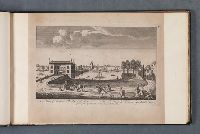
2. A north view of Westminster Bridge Vüe du Pont de Westminster du cote du nord. [graphic] =
- Published / Created:
- [1753]
- Call Number:
- Folio 75 L847 750
- Collection Title:
- Leaf 22. London and its environs about 1750.
- Image Count:
- 1
- Resource Type:
- still image
- Abstract:
- "View of Westminster Bridge from the centre of the Thames; a number of small boats in foreground; Westminster Abbey and Hall beyond bridge to the right."--British Museum online catalogue
- Alternative Title:
- Vüe du Pont de Westminster du cote du nord
- Description:
- Titles etched below image, in English and French., Date of publication from description of 19th-century reissue by Francis West; see British Museum online catalogue, registration no.: 1875,0508.1462., Plate reissued by Sayer and Bennett and listed in their 1775 catalogue as part of the series "Twelve views of the city of London and public buildings therein, accurately engraved from the originals taken on the spot", in the section on "Sets of small prints"; see: Sayer and Bennett's enlarged catalogue of new and valuable prints. London : [Sayer and Bennett], 1775, page 86, no. 8., Plate numbered "3" in upper right corner., and Leaf 22 in an album of views of London and its vicinity.
- Publisher:
- Printed for Robt. Sayer, map & printseller, at the Golden Buck near Serjeants Inn, Fleet Street
- Subject (Geographic):
- London (England), Thames River (England),, Westminster Bridge (London, England),, England, and London.
- Subject (Name):
- Westminster Abbey, and Westminster Hall (London, England),
- Subject (Topic):
- Bridges, Rivers, and Boats
- Found in:
- Lewis Walpole Library > A north view of Westminster Bridge Vüe du Pont de Westminster du cote du nord. [graphic] =
3. A perspective view of Twickenham Vüe du village de Twickenham. [graphic] =
- Published / Created:
- [not before 1747]
- Call Number:
- Folio 75 L847 750
- Collection Title:
- Leaf 2. London and its environs about 1750.
- Image Count:
- 1
- Resource Type:
- still image
- Abstract:
- "View of Twickenham, looking over the River Thames; the houses on the opposite shore reflected in the water; a barge and rowing boat in foreground."--British Museum online catalogue
- Alternative Title:
- Vüe du village de Twickenham
- Description:
- Titles etched below image, in English and French., Probably after a design by Heckel; statement of responsibility "A. Heckel delint." is present on another print of identical composition. Cf. British Museum online catalogue, registration no.: 1875,0508.1447., Date of publication based on Robert Sayer's earliest year of activity. The address "near Sergeants Inn, Fleet Street" only appears on his very early prints; see British Museum online catalogue., Plate reissued by Sayer and Bennett and listed in their 1775 catalogue as part of the series "Views of villages, noblemen and gentlemen's seats, &c. situate on, or near the river Thames", in the section on "Sets of small prints"; see: Sayer and Bennett's enlarged catalogue of new and valuable prints. London : [Sayer and Bennett], 1775, page 88, no. 13., Plate numbered "No. 3" in upper left corner and "1" in upper right corner., Mounted to 24 x 38 cm., and Leaf 2 in an album of views of London and its vicinity.
- Publisher:
- Printed for Robert Sayer, map & printseller near Serjeants Inn, Fleet Street
- Subject (Geographic):
- Twickenham (London, England) and Thames River (England)
- Subject (Topic):
- Barges, Rowboats, Rivers, and Dwellings
- Found in:
- Lewis Walpole Library > A perspective view of Twickenham Vüe du village de Twickenham. [graphic] =
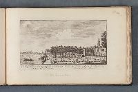
4. A perspective view of the Royal Garden of Somerset, next the river Vüe de Jarden Royal de Somerset, du cote de la riviere / [graphic] =
- Creator:
- Maurer, J. active 1713-1761, printmaker, artist
- Published / Created:
- publish'd according to act of Parliament, [1753]
- Call Number:
- Folio 75 L847 750
- Collection Title:
- Leaf 43. London and its environs about 1750.
- Image Count:
- 1
- Resource Type:
- still image
- Abstract:
- "View of the gardens fronting Somerset House, with the River Thames on the left, Westminster Abbey and Bridge in the distance on the left, and Somerset House and gardens on the right."--British Museum online catalogue
- Alternative Title:
- Vüe de Jarden Royal de Somerset, du cote de la riviere
- Description:
- Titles etched below image, in English and French., Later state; remnants of burnished imprint visible at bottom of plate., Plate reissued by Sayer and Bennett and listed in their 1775 catalogue as part of the series "Twelve perspective views of the principal churches, streets, and squares in the cities of London and Westminster", in the section on "Sets of small prints"; see: Sayer and Bennett's enlarged catalogue of new and valuable prints. London : [Sayer and Bennett], 1775, pages 87, no. 10., Plate numbered "12" in upper right corner., Watermark: 1817., Leaf 43 in an album of views of London and its vicinity., and Pencil annotation below plate line, in a later hand: Old Somerset House.
- Publisher:
- publisher not identified
- Subject (Geographic):
- London (England), Thames River (England),, Westminster Bridge (London, England),, England, and London.
- Subject (Name):
- Somerset House (London, England), and Westminster Abbey,
- Subject (Topic):
- Gardens, Rivers, Castles & palaces, Bridges, and Boats
- Found in:
- Lewis Walpole Library > A perspective view of the Royal Garden of Somerset, next the river Vüe de Jarden Royal de Somerset, du cote de la riviere / [graphic] =
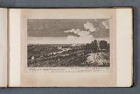
5. A view from Richmond Hill down the river Paisage du haut de la Montagne de Richmond en descendant la Tamise. [graphic] =
- Published / Created:
- [not before 1747]
- Call Number:
- Folio 75 L847 750
- Collection Title:
- Leaf 4. London and its environs about 1750.
- Image Count:
- 1
- Resource Type:
- still image
- Abstract:
- "View of the town from Richmond Hill, the Thames at the centre, a road in the right foreground with figures and a coach."--British Museum online catalogue
- Alternative Title:
- Paisage du haut de la Montagne de Richmond en descendant la Tamise
- Description:
- Titles etched below image, in English and French., Date of publication based on Robert Sayer's earliest year of activity. The address "near Sergeants Inn, Fleet Street" only appears on his very early prints; see British Museum online catalogue., Plate reissued by Sayer and Bennett and listed in their 1775 catalogue as part of the series "Views of villages, noblemen and gentlemen's seats, &c. situate on, or near the river Thames", in the section on "Sets of small prints"; see: Sayer and Bennett's enlarged catalogue of new and valuable prints. London : [Sayer and Bennett], 1775, page 88, no. 13., Plate numbered "3" in upper right corner., Mounted to 24 x 39 cm., and Leaf 4 in an album of views of London and its vicinity.
- Publisher:
- Printed for Robt. Sayer, map & printseller near Serjeants Inn, Fleet Street
- Subject (Geographic):
- Richmond upon Thames (London, England), Thames River (England), England, and London.
- Subject (Topic):
- Rivers, Roads, Carriages & coaches, and Dwellings
- Found in:
- Lewis Walpole Library > A view from Richmond Hill down the river Paisage du haut de la Montagne de Richmond en descendant la Tamise. [graphic] =
6. A view from Richmond Hill up the river Paisage du haut de la Montagne de Richmond en assendant la Tamise. [graphic] =
- Published / Created:
- [not before 1747]
- Call Number:
- Folio 75 L847 750
- Collection Title:
- Leaf 3. London and its environs about 1750.
- Image Count:
- 1
- Resource Type:
- still image
- Abstract:
- "View of the Thames from Richmond Hill, with animals grazing in the foreground, a woman guiding a herd of cows towards the right, a coach and a covered cart going in opposite directions, and three figures talking at the centre."--British Museum online catalogue
- Alternative Title:
- Paisage du haut de la Montagne de Richmond en assendant la Tamise
- Description:
- Titles etched below image, in English and French., Probably after a painting by Jolly; statement of responsibility "Jolly pinxit" is present on another print of identical composition. Cf. British Museum online catalogue, registration no.: 1875,0508.1436., Date of publication based on Robert Sayer's earliest year of activity. The address "near Sergeants Inn, Fleet Street" only appears on his very early prints; see British Museum online catalogue., Plate reissued by Sayer and Bennett and listed in their 1775 catalogue as part of the series "Views of villages, noblemen and gentlemen's seats, &c. situate on, or near the river Thames", in the section on "Sets of small prints"; see: Sayer and Bennett's enlarged catalogue of new and valuable prints. London : [Sayer and Bennett], 1775, page 88, no. 13., Plate numbered "2" in upper right corner., Mounted to 24 x 38 cm., and Leaf 3 in an album of views of London and its vicinity.
- Publisher:
- Printed for Robt. Sayer, map & printseller near Serjeants Inn, Fleet Street
- Subject (Geographic):
- Richmond upon Thames (London, England), Thames River (England), England, and London.
- Subject (Topic):
- Rivers, Boats, Livestock, Carriages & coaches, and Dwellings
- Found in:
- Lewis Walpole Library > A view from Richmond Hill up the river Paisage du haut de la Montagne de Richmond en assendant la Tamise. [graphic] =

7. A view of Chelsea Vüe du village de Chelsea. [graphic] =
- Published / Created:
- [not before 1747]
- Call Number:
- Folio 75 L847 750
- Collection Title:
- Leaf 9. London and its environs about 1750.
- Image Count:
- 1
- Resource Type:
- still image
- Abstract:
- "View of the Thames with boats afloat, three figures conversing in the left foreground."--British Museum online catalogue
- Alternative Title:
- Vüe du village de Chelsea
- Description:
- Titles etched below image, in English and French., Date of publication based on Robert Sayer's earliest year of activity. The address "near Sergeants Inn, Fleet Street" only appears on his very early prints; see British Museum online catalogue., Plate reissued by Sayer and Bennett and listed in their 1775 catalogue as part of the series "Views of villages, noblemen and gentlemen's seats, &c. situate on, or near the river Thames", in the section on "Sets of small prints"; see: Sayer and Bennett's enlarged catalogue of new and valuable prints. London : [Sayer and Bennett], 1775, page 88, no. 13., Plate numbered "8" in upper right corner., Mounted to 24 x 39 cm., and Leaf 9 in an album of views of London and its vicinity.
- Publisher:
- Printed for Robert Sayer, map & printseller near Serjeants Inn, Fleet Street
- Subject (Geographic):
- Chelsea (London, England), Thames River (England), England, and London.
- Subject (Topic):
- Rivers, Sailboats, and Rowboats
- Found in:
- Lewis Walpole Library > A view of Chelsea Vüe du village de Chelsea. [graphic] =
8. A view of Fulham Bridge and Putney La veüe du Pont de Fulham regardant Putney. [graphic] =
- Published / Created:
- [not before 1747]
- Call Number:
- Folio 75 L847 750
- Collection Title:
- Leaf 7. London and its environs about 1750.
- Image Count:
- 1
- Resource Type:
- still image
- Abstract:
- "View at the entrance to the bridge, looking across the river towards Putney; people passing in foreground including a man with a donkey, and a milkmaid with yoke and pails."--British Museum online catalogue
- Alternative Title:
- Veüe du Pont de Fulham regardant Putney
- Description:
- Titles etched below image, in English and French., Date of publication based on Robert Sayer's earliest year of activity. The address "near Sergeants Inn, Fleet Street" only appears on his very early prints; see British Museum online catalogue., Plate reissued by Sayer and Bennett and listed in their 1775 catalogue as part of the series "Views of villages, noblemen and gentlemen's seats, &c. situate on, or near the river Thames", in the section on "Sets of small prints"; see: Sayer and Bennett's enlarged catalogue of new and valuable prints. London : [Sayer and Bennett], 1775, page 88, no. 13., Plate numbered "6" in upper right corner., Mounted to 24 x 38 cm., and Leaf 7 in an album of views of London and its vicinity.
- Publisher:
- Printed for Robt. Sayer, map & printseller near Serjeants Inn, Fleet Street
- Subject (Geographic):
- Putney (London, England), Thames River (England), England, and London.
- Subject (Topic):
- Rivers, Bridges, Pedestrians, Sailboats, and Rowboats
- Found in:
- Lewis Walpole Library > A view of Fulham Bridge and Putney La veüe du Pont de Fulham regardant Putney. [graphic] =
9. A view of Richmond Hill from the Earl of Cholmondelly's Vue de la Montagne de Richmond de la maison du Conte de Cholmondelly / [graphic] =
- Creator:
- Sparrow, James, printmaker
- Published / Created:
- [not before 1747]
- Call Number:
- Folio 75 L847 750
- Collection Title:
- Leaf 10. London and its environs about 1750.
- Image Count:
- 1
- Resource Type:
- still image
- Abstract:
- "The Thames at the centre with boats on the water, figures on the quay to the right, a mansion by the quay and the city in the back, Richmond Hill in the background."--British Museum online catalogue
- Alternative Title:
- View of Richmond Hill from the Earl of Cholmondeley's and Vue de la Montagne de Richmond de la maison du Conte de Cholmondelly
- Description:
- Titles etched below image, in English and French., Date of publication based on Robert Sayer's earliest year of activity. The address "near Sergeants Inn, Fleet Street" only appears on his very early prints; see British Museum online catalogue., Plate reissued by Sayer and Bennett and listed in their 1775 catalogue as part of the series "Views of villages, noblemen and gentlemen's seats, &c. situate on, or near the river Thames", in the section on "Sets of small prints"; see: Sayer and Bennett's enlarged catalogue of new and valuable prints. London : [Sayer and Bennett], 1775, page 88, no. 13., Imperfect; plate number erased from sheet and replaced with number "6" written in ink. Missing number supplied from impression in the British Museum, registration no.: 1872,1012.5399., Plate numbered "4" in upper right corner., Mounted to 24 x 39 cm., and Leaf 10 in an album of views of London and its vicinity.
- Publisher:
- Printed for Robt. Sayer, map & printseller, at the Golden Buck near Serjeants Inn, Fleetstreet
- Subject (Geographic):
- Richmond (London, England), Thames River (England), England, and London.
- Subject (Name):
- Cholmondeley, George Cholmondeley, Earl of, 1703-1770
- Subject (Topic):
- Homes and haunts, Rivers, Dwellings, Piers & wharves, and Boats
- Found in:
- Lewis Walpole Library > A view of Richmond Hill from the Earl of Cholmondelly's Vue de la Montagne de Richmond de la maison du Conte de Cholmondelly / [graphic] =