Skip to search
Skip to main content
Skip to first result
Search
You Searched For
Subject Heading
Europe > Maps > Early works to 1800
Search Results
Creator:
Published / Created:
June the 24th, 1788.
Call Number:
1982 Folio 10
Image Count:
2
Description:
BEIN 1982 Folio 10: Armorial bookplate: Charles Abbot. No. 20 of 42 maps bound together.
Publisher:
William Faden
Subject (Geographic):
Europe and Germany
Subject (Topic):
Administrative and political divisions
Found in:
Beinecke Rare Book and Manuscript Library > A new map of the German Empire and the neighbouring states with their principal post roads : originally published by the Royal Academy of Berlin
Published / Created:
1795.
Call Number:
Osborn pc259
Image Count:
4
Alternative Title:
Bowles' European geographical amusement, Game of Geography, and Bowles's geographical game of Europe
Description:
BEIN Osborn pc259: Imperfect: wanting pillars or counters.
Publisher:
Printed for the proprietors Bowles & Carver
Subject (Geographic):
Europe
Subject (Topic):
Geographical recreations
Found in:
Beinecke Rare Book and Manuscript Library > Bowles's European geographical amusement, or, Game of geography : designed from The grand tour of Europe, by Dr. Nugent
Creator:
Published / Created:
[1706?]
Call Number:
1973 Folio 18
Image Count:
1
Description:
BEIN 1973 Folio 18: Backed with paper. Ms. no. "3" in upper right-hand corner. Sheet measures 53.4 x 62.0 cm. No. 2 of 87 maps bound together.
Publisher:
Á Petro Schenk
Subject (Geographic):
Europe
Subject (Topic):
Solar eclipses and Maps
Found in:
Beinecke Rare Book and Manuscript Library > Eclipseos solis totalis cum mora d[ie] 12 Maii 1706, horis antem: in Europa celebratae, geographica repraesentatio in qua centralis umbrae tractus ac reliquae magnitudines suis locis competentes, ex illustrium virorum observationibus deductae, per arcus parallelos, ceu digitorum singulorum indices / [cartographic material]
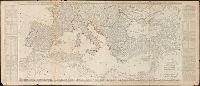
Creator:
Published / Created:
[1743?]
Call Number:
1983 Folio 23
Image Count:
1
Description:
BEIN 1983 Folio 23: Hand col. Sheet measures 54.5 x 63.8 cm. No. 2 of 50 maps bound together.
Publisher:
Edita curis Homannianorum Heredum
Subject (Geographic):
Europe
Found in:
Beinecke Rare Book and Manuscript Library > Europa, secundum legitimas projectionis stereographicae regulas : et juxta recentissimas observationes aeque ac relationes adhibitis quoq[ue] veterum monumentorum subsidiis
Creator:
Published / Created:
A. MDCCXXXXIII [1743]
Call Number:
1975 Folio 31
Image Count:
1
Description:
BEIN 1975 Folio 31: Imperfect: torn along fold and frayed along edges, with no loss of text. Sheet measures 53.1 x 59 cm. No. 2 of 42 maps bound together.
Publisher:
Edita curis Homannianorum Heredum
Subject (Geographic):
Europe
Found in:
Beinecke Rare Book and Manuscript Library > Europa, secundum legitimas projectionis stereographicae regulas : et juxta recentissimas observationes aeque ac relationes adhibitis quoq[ue] veterum monumentorum subsidiis
Creator:
Published / Created:
A. MDCCXXXXIII [1743]
Call Number:
1973 Folio 30
Image Count:
1
Description:
BEIN 1973 Folio 30: Imperfect: torn along fold and mutilated, with no loss of text. Sheet measures 53.1 x 61.7 cm. No. 2 of 32 maps bound together.
Publisher:
Edita curis Homannianorum Heredum
Subject (Geographic):
Europe
Found in:
Beinecke Rare Book and Manuscript Library > Europa, secundum legitimas projectionis stereographicae regulas et juxta recentissimas observationes aeque ac relationes adhibitis quoq[ue] veterum monumentorum subsidiis / [cartographic material]
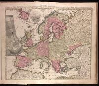
Creator:
Published / Created:
Jany. 1st, 1787.
Call Number:
1982 Folio 10
Image Count:
2
Resource Type:
cartographic image
Description:
BEIN 1982 Folio 10: Armorial bookplate: Charles Abbot. No. 4 of 42 maps bound together.
Publisher:
Published by Robt. Sayer, Fleet Street as the act directs
Subject (Geographic):
Europe, Middle East, and Africa, North
Found in:
Beinecke Rare Book and Manuscript Library > Europe divided into its empires, kingdoms, states, republics, & ca.
Creator:
Published / Created:
Jany. 1st, 1787.
Call Number:
30 1787
Image Count:
1
Resource Type:
cartographic image
Description:
BEIN 1982 Folio 10: Armorial bookplate: Charles Abbot. No. 4 of 42 maps bound together.
Publisher:
Published by Robt. Sayer, Fleet Street as the act directs
Subject (Geographic):
Europe, Middle East, and Africa, North
Found in:
Beinecke Rare Book and Manuscript Library > Europe divided into its empires, kingdoms, states, republics, & ca.
Creator:
Published / Created:
Jany. 1st, 1787.
Call Number:
49 1800
Image Count:
1
Resource Type:
cartographic image
Description:
BEIN 1982 Folio 10: Armorial bookplate: Charles Abbot. No. 4 of 42 maps bound together.
Publisher:
Published by Robt. Sayer, Fleet Street as the act directs
Subject (Geographic):
Europe, Middle East, and Africa, North
Found in:
Beinecke Rare Book and Manuscript Library > Europe divided into its empires, kingdoms, states, republics, & ca.
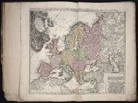
Creator:
Published / Created:
1680.
Call Number:
1973 Folio 10
Image Count:
1
Alternative Title:
Europe divided into its principall parts viz. the Brittish [sic] Islands, Scandinavia, Moscovia, France, Germany, Poland, Spain, Italy, Turky [sic] in Europe ... described by Sanson, corrected and amended by William Berry
Description:
BEIN 1973 Folio 10: Sheet measures 61 x 96.3 cm. Bookplate of José M. Rodriguez. No. 2 of 63 maps bound together.
Publisher:
Sold by William Berry at ye sign of the globe between Charing-Cross and White-Hall
Subject (Geographic):
Europe, Russia, and Turkey
Found in:
Beinecke Rare Book and Manuscript Library > Europe divided into its principall states, which are subdivided into their principall provinces