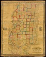
State of Mississippi, with a large portion of Louisiana and Alabama
Description:
BEIN Roll Map 420: Mounted on linen. Printed label on verso: Rhode Island Historical Society., Relief shown by shading., "Scale 6 miles to the inch.", Prime meridian: Washington, D.C. Coordinates converted by cataloger to express longitude as measured from the Greenwich meridian., Includes list of land districts and legend. Some ancillary maps include indexes., Ornamental border., and "Entered according to Act of Congress in the year 1839 by John La Tourrette in the Clerk's Office of the District Court of the Southern District of Alabama."
Publisher:
Compiled & published by John La Tourrette and Engraved by S. Stiles, Sherman & Smith
Subject (Geographic):
Mississippi, Alabama, Louisiana, Alabama., Louisiana., and Mississippi.
BEIN JWJ Za C739 955co: Original wrappers. Inscription of Mamie E. Bradley, Emmett Till's mother. and "Authentic pictures teken on the spot designed to meet public demand"--Cover.