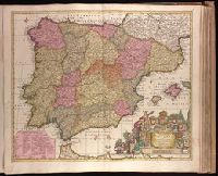
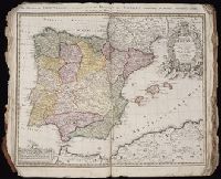
Carte general d ́Espagne et de Portugal diviseé en ses provinces actuelles par D.T. Lopez, nouvellement dressée par F.L.G. à Nuremberg chez les Heret. de Homann l ́an 1782
Description:
BEIN 39 1782: Imperfect: top edge chewed, with no loss of text. Sheet measures 54.6 x 61.3 cm.
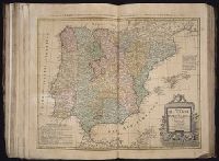
Regnorvm Hispaniae et Portvgalliae tabula generalis de l'Isliana and Reyno de Espanna dividido en dos grandes estados de Aragón y de Castilla, subdividido en muchas provincias donde se halla también el Reyno de Portugal
Description:
BEIN 1973 Folio 30: Imperfect: torn along fold, with no loss of text. Sheet measures 53.9 x 62 cm. No. 5 of 32 maps bound together.
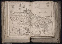
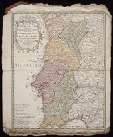
Reyno de Espanna dividido en dos grandes estados de Aragón y de Castilla, subdividido en muchas provincias donde se halla también el Reyno de Portvgal
Description:
BEIN 1975 Folio 31: Imperfect: torn along fold and frayed along edges, with no loss of text. Sheet measures 53.2 x 60.7 cm. No. 4 of 42 maps bound together.
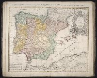
BEIN 1975 Folio 31: Imperfect: torn along fold and frayed along edges, with some loss of imprint. Sheet measures 60 x 53.2 cm. No. 3 of 42 maps bound together.
Publisher:
Edita primum per I. B. Nolin, nunc recusa per H.H. [heredes Homannianos]
Coates, Thomas, approximately 1802-1883, collector
Published / Created:
[1834-1836]
Call Number:
Quarto 724 834C
Image Count:
111
Resource Type:
still image
Abstract:
An album compiled by Thomas Coates, solicitor and sometime secretary to the Society for the Diffusion of Useful Knowledge, containing 340 proofs of wood engravings mounted on 68 leaves, with section titles and descriptions: Illustrations of the Hindoo...
Description:
Title from dealer's description.
Subject (Geographic):
Canada., Canada, Egypt, India, Portugal, and Spain