Skip to search
Skip to main content
Skip to first result
Search
You Searched For
Subject Heading
Saxony (Germany) > Maps > Early works to 1800
Search Results
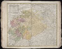
Creator:
Published / Created:
1734.
Call Number:
1975 Folio 31
Image Count:
1
Description:
BEIN 1975 Folio 31: Imperfect: edges frayed, with no loss of text. Sheet measures 53.4 x 62.2 cm. No. 28 of 42 maps bound together.
Publisher:
Homann Erben
Subject (Geographic):
Saxony (Germany)
Found in:
Beinecke Rare Book and Manuscript Library > Circuli supe. Saxoniae pars meridionalis : sive ducatus, electoratus et principatus Ducum Saxoniae
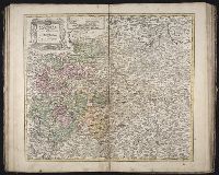
Creator:
Published / Created:
1757.
Call Number:
1973 Folio 30
Image Count:
2
Description:
BEIN 1973 Folio 30: Sheet measures 53.7 x 61.3 cm. Some city names underlined in ms. No. 14 of 50 maps bound together.
Publisher:
Homann Erben
Subject (Geographic):
Saxony (Germany)
Found in:
Beinecke Rare Book and Manuscript Library > Circuli supe. Saxoniae pars meridionalis sive Ducatus, Electoratus et Principatus Ducum Saxoniae
Creator:
Published / Created:
1757.
Call Number:
1977 Folio 177
Image Count:
3
Description:
BEIN 1973 Folio 30: Sheet measures 53.7 x 61.3 cm. Some city names underlined in ms. No. 14 of 50 maps bound together.
Publisher:
Homann Erben
Subject (Geographic):
Saxony (Germany)
Found in:
Beinecke Rare Book and Manuscript Library > Circuli supe. Saxoniae pars meridionalis sive Ducatus, Electoratus et Principatus Ducum Saxoniae
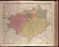
Creator:
Published / Created:
ca. 1702?]
Call Number:
1973 Folio 18
Image Count:
1
Description:
BEIN 1973 Folio 18: Backed with paper. Ms. no. in upper right corner: 24. Sheet measures 53.7 x 62.7 cm. No. 24 of 87 maps bound together.
Publisher:
Gerard Valck
Subject (Geographic):
Brandenburg (Germany), Saxony (Germany), Saxony-Anhalt (Germany), and Thuringia (Germany)
Subject (Topic):
Maps
Found in:
Beinecke Rare Book and Manuscript Library > Circulus Saxoniae superioris, divisa in ducatus Saxoniae, Altenburgi, Vinariae, Gothae, et Isenaci, principatum Anhaltinum, comitatus Suartenburgi, Barbiae, et Bichlingii, episcoptatius Ceitzii et Halae, cum reliquis ditionibus [cartographic material]
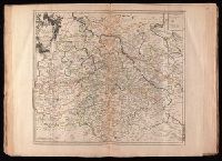
Creator:
Published / Created:
1783.
Call Number:
1983 Folio 23
Image Count:
1
Alternative Title:
Circuli superioris Saxoniae pars meridionalis, Ducatum, Electoratum & Principatus Ducum Saxoniae, Princip. Anhalt. Comit. Schwarzburg, Mansfeld, Stolberg &cc
Description:
BEIN 1983 Folio 23: Sheet measures 54.4 x 64.1 cm. No. 40 of 50 maps bound together.
Publisher:
Homann Erben
Subject (Geographic):
Brandenburg (Germany), Saxony-Anhalt (Germany), Saxony (Germany), and Thuringia (Germany)
Found in:
Beinecke Rare Book and Manuscript Library > Der südliche Theil des Ober-Saechsischen Kreises : die Chur-und Fürstl Sächsische und andere hiehergehörige Länder vorstellend
Creator:
Published / Created:
ca. 1757]
Call Number:
1973 Folio 30
Image Count:
2
Description:
BEIN 1973 Folio 30: Sheet measures 53.8 x 61.9 cm. No. 25 of 32 maps bound together.
Publisher:
Tobias Conrad Lotter
Subject (Geographic):
Saxony (Germany)
Found in:
Beinecke Rare Book and Manuscript Library > Electoratus Saxonici Praefecturae Annaburgensis, Pretzschens[is] Torgaviensis, Schweinicensis, Mühlbergensis studio geographico / [cartographic material]
Creator:
Published / Created:
1743.
Call Number:
1977 Folio 177
Image Count:
2
Description:
BEIN 1977 Folio 177: Stamp on verso: 286. Ms. title on verso. Sheet measures 54.3 x 68.7 cm. No. 31 of 34 maps bound together.
Publisher:
Par et chez le Sr. le Rouge ingenieur geographe du roi rüe des grand.s Augustins vis a vis le panier fleuri
Subject (Geographic):
Germany, Saxony, Saxony (Germany), Saxony-Anhalt (Germany), and Thuringia (Germany)
Subject (Topic):
Post roads
Found in:
Beinecke Rare Book and Manuscript Library > La Saxe contenant les routtes et les postes [cartographic material].
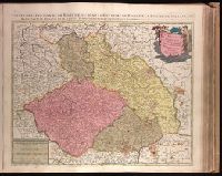
Creator:
Published / Created:
[ca. 1700]
Call Number:
1973 Folio 18
Image Count:
1
Alternative Title:
Estats de la couronne de Boheme, ou, Sont le royaume de Boheme, duché de Silésie, les marquisat de Moravie et de Lusace subdivisés en leurs principales parties / dressé sur les memoires les plus nouveaux par Sanson and Sont le royaume de Boheme, duché de Silésie, les marquisat de Moravie et de Lusace subdiviseés en leurs principales parties
Description:
BEIN 1973 Folio 18: Backed with paper. Ms. no. in upper right corner: 25. Sheet measures 53.7 x 62.7 cm. No. 25 of 87 maps bound together.
Publisher:
Chez Pierre Schenck, avec privilege de nos Seigneurs les Etats de Hollande et de West-Frise
Subject (Geographic):
Czech Republic, Saxony (Germany), and Poland
Subject (Topic):
Maps
Found in:
Beinecke Rare Book and Manuscript Library > Le royaume de Boheme, duché de Silésie, les marquisat de Moravie et de Lusace [cartographic material]