Skip to search
Skip to main content
Skip to first result
Search
You Searched For
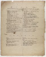
Subject Heading
Shipping
Search Results
Published / Created:
[1760]
Call Number:
File 18 H913+
Image Count:
1
Description:
Single sheet publication. Printed in two columns.
Publisher:
s.n.
Subject (Geographic):
England, Hull., and Baltic Sea
Subject (Topic):
Imports, Exports, Shipping, and Commerce
Found in:
Lewis Walpole Library > Hull
Creator:
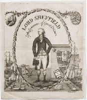
Published / Created:
[1790?]
Call Number:
790.00.00.10.1
Image Count:
1
Resource Type:
still image
Abstract:
Portrait of Lord Sheffield within an ornamental oval border
Alternative Title:
Lord Sheffield and the commerce of Great Britain
Description:
Title from item.
Publisher:
publisher not identified
Subject (Name):
Sheffield, John Holroyd, Earl of, 1735-1821,
Subject (Topic):
Liberty cap, Commerce, Coats of arms, Shipping, and Sailing ships
Found in:
Lewis Walpole Library > Lord Sheffield & the commerce of Great Britain [graphic]
Published / Created:
[1774]
Call Number:
File 63 774 P839+
Image Count:
2
Resource Type:
text
Description:
Single sheet publication. Printed in two columns.
Publisher:
publisher not identified
Subject (Geographic):
England, Hull., and Hull (England)
Subject (Topic):
Commerce, Imports, Exports, and Shipping
Found in:
Lewis Walpole Library > Port Hull
Creator:
Published / Created:
1885.
Call Number:
Xu911 885m
Image Count:
246
Alternative Title:
Russkai︠a︡ bibliografii︠a︡ morskogo dela za 1701-1882 god vkli︠u︡chitelʹno
Description:
2,327 entries.
Publisher:
Tip. V. Bezobrazova
Subject (Topic):
Navigation, Shipping, and Maritime law
Found in:
Sterling Memorial Library > Russkai︠a︡ biblīografīi︠a︡ morskago di︠e︡la za 1701-1882 god vkli︠u︡chitelʹno spet︠s︡īalʹnyĭ katalog russkikh knig po vsi︠e︡m otrasli︠a︡m znanīĭ otnosi︠a︡shchikhsi︠a︡ do morskago di︠e︡la : s dvumi︠a︡ podrobnymi alfavitnymi ukazateli︠a︡mi
Creator:
Published / Created:
[1859]
Call Number:
File 86 859 C125++
Image Count:
1
Alternative Title:
California & New York Steamship Company
Description:
Caption title
Publisher:
C.J. Bartram, printer, 102 Maiden Lanes, N.Y.
Subject (Geographic):
United States. and Pacific Coast.
Subject (Name):
Panama Railroad Co.
Subject (Topic):
Mail steamers, Shipping, and Steamboat lines
Found in:
Lewis Walpole Library > Through to San Francisco! : Aspinwall & Panama, at greatly reduced rates. No detention on the Isthmus. The new and fast side-wheel double engine steam ship Union ... will leave Monday, June 6th, at 3 p.m., precisely, connecting with the new and magnificent side-wheel double engine steamship Cortes ... tickets are sold only at 26 Broadway, N.Y. Davis, Brooks & Co. general agents. A mail bag is made up at the above office, under the new U.S. postage law, for the convenience of the public
Creator:
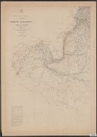
Published / Created:
1847-1852.
Call Number:
Maury Charts 11cfk 1850A-4 2
Image Count:
5
Alternative Title:
Maury's wind & current chart and Maury's wind and current chart
Description:
BEIN: 11cfk 1850A-4: Var. editions. 1 copy each of sheets 1-4 and sheets 5-8 mounted together on linen.
Publisher:
U.S. Hydrographical Office
Subject (Geographic):
North Atlantic Ocean. and North Atlantic Ocean
Subject (Topic):
Nautical charts, Winds, Ocean currents, Trade routes, Shipping, and Oceanography
Found in:
Beinecke Rare Book and Manuscript Library > Wind and current chart of the North Atlantic [cartographic material]
Creator:
Published / Created:
1847-1852.
Call Number:
Maury Charts 11cfk 1850A-4 1
Image Count:
8
Alternative Title:
Maury's wind & current chart and Maury's wind and current chart
Description:
BEIN: 11cfk 1850A-4: Var. editions. 1 copy each of sheets 1-4 and sheets 5-8 mounted together on linen.
Publisher:
U.S. Hydrographical Office
Subject (Geographic):
North Atlantic Ocean. and North Atlantic Ocean
Subject (Topic):
Nautical charts, Winds, Ocean currents, Trade routes, Shipping, and Oceanography
Found in:
Beinecke Rare Book and Manuscript Library > Wind and current chart of the North Atlantic [cartographic material]
Creator:
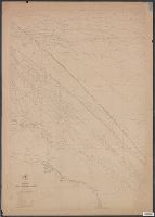
Published / Created:
[1781]
Call Number:
Folio 75 B935 805 folder 34 Box 3
Collection Title:
[Scrapbook of drawings].
Image Count:
1
Resource Type:
still image
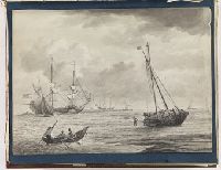
Abstract:
Wash drawing depicting several ships just offshore. Three men in a small boat row towards a ship that looks to have run aground; a man stands on the sandbar(?) beside the incapacitated ship with his arm raised
Alternative Title:
Gale
Description:
Title from local catalog card; alternative title from the print after which the drawing was made.
Subject (Topic):
Shipping and Ships
Found in:
Lewis Walpole Library > [Shipping scene] [art original]
Creator:
Published / Created:
[1781]
Call Number:
Folio 75 B935 805 folder 34 Box 3
Collection Title:
[Scrapbook of drawings].
Image Count:
1
Resource Type:
still image
Abstract:
Wash drawing depicting several ships just offshore. Three men in a small boat row towards a ship that looks to have run aground; a man stands on the sandbar(?) beside the incapacitated ship with his arm raised
Alternative Title:
Gale
Description:
Title from local catalog card; alternative title from the print after which the drawing was made.
Subject (Topic):
Shipping and Ships
Found in:
Lewis Walpole Library > [Shipping scene] [art original]