Geographical Surveys West of the 100th Meridian (U.S.)
Published / Created:
1871-72.
Call Number:
WA Photos Folio 56
Image Count:
13
Abstract:
Mounted photographs of Arizona, Nevada, and Utah created by Timothy H. O'Sullivan, with a single photographic print by William Bell, that document the Geographical Surveys West of the 100th Meridian led by George Montague Wheeler for the United States...
Description:
Accompanied by a box list.
Subject (Geographic):
Arizona, Black Canyon (Ariz. and Nev.), Colorado River (Colo.-Mexico), Grand Canyon (Ariz.), Logan (Nev.), Marble Canyon (Coconino County, Ariz. : Canyon), Nevada, Paria River (Utah and Ariz.), United States, and Utah
Subject (Name):
Bell, William, 1830-1910., Gilbert, Grove Karl, 1843-1918., O'Sullivan, Timothy H., 1840-1882, Wheeler, George M. 1842-1905. (George Montague),, Geographical Surveys West of the 100th Meridian (U.S.), and United States. War Department.
Subject (Topic):
Architecture, Details, Exploring expeditions, and Surveys
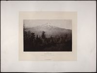
Photographs in California of Mount Shasta, Mount Lassen, and the Whitney Glacier
Description:
Carleton E. Watkins was a San Francisco photographer who worked both with official surveys and independently to photograph California, Nevada and Utah. In 1867 he served with Clarence King as the official photographer to the California Geological Sur...
Publisher:
U.S. Engineer Department
Subject (Geographic):
United States and California
Subject (Name):
United States Geological Exploration of the Fortieth Parallel
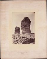
Photographs of Nevada, Idaho, Wyoming, Arizona, and Utah, including views of the Humbolt Mountains, Pyramid Lake and mining districts in Nevada; Shoshone Falls and the Snake River in Idaho; Twin Bluffs along the Green River in Wyoming; the Grand Canyo...
Description:
Accompanied by a box list.
Subject (Geographic):
United States, Arizona, Grand Canyon (Ariz.), Nevada, Idaho, and Wyoming
Subject (Name):
Geographical Surveys West of the 100th Meridian (U.S.) and United States Geological Exploration of the Fortieth Parallel
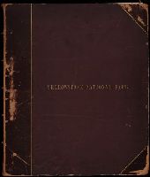
Geological and Geographical Survey of the Territories (U.S.)
Published / Created:
1873.
Call Number:
WA Photos Folio 53
Container / Volume:
Volume (copy 1)
Image Count:
93
Abstract:
Two versions of a viewbook distributed by the United States Geological and Geographical Survey of the Territories in 1873 with mounted photographic prints created by William Henry Jackson of camps, geothermal features, and landscape primarily in Yello...
Description:
Each photograph is accompanied by a guard sheet with descriptive letter-press captions.
Publisher:
Government Printing Office
Subject (Geographic):
Yellowstone National Park., Blackmore, Mount (Mont.), Bridger Canyon (Mont.), Firehole River (Wyo.), Fort Hall (Idaho : Fort), Gallatin Canyon (Mont.), Gallatin River (Wyo. and Mont.), Grand Teton (Wyo.), Grand Teton National Park (Wyo.), Idaho, Lower Falls of the Yellowstone River (Wyo.), Mammoth Hot Springs (Wyo.), Montana, Teton Range (Wyo. and Idaho), Tower Creek (Wyo.), Upper Falls of the Yellowstone River (Wyo.), Upper Geyser Basin (Wyo.), Utah, Wasatch Range (Utah and Idaho), Wyoming, Yellowstone National Park, Yellowstone River, and Yellowstone River Valley
Subject (Name):
Jackson, William Henry, 1843-1942. and Geological and Geographical Survey of the Territories (U.S.)
Subject (Topic):
Discoveries in geography, American, Rock formations, United States, Discovery and exploration, and Surveys
Geological and Geographical Survey of the Territories (U.S.)
Published / Created:
1873.
Call Number:
WA Photos Folio 53
Container / Volume:
Volume (copy 2)
Image Count:
94
Abstract:
Two versions of a viewbook distributed by the United States Geological and Geographical Survey of the Territories in 1873 with mounted photographic prints created by William Henry Jackson of camps, geothermal features, and landscape primarily in Yello...
Description:
Each photograph is accompanied by a guard sheet with descriptive letter-press captions.
Publisher:
Government Printing Office
Subject (Geographic):
Yellowstone National Park., Blackmore, Mount (Mont.), Bridger Canyon (Mont.), Firehole River (Wyo.), Fort Hall (Idaho : Fort), Gallatin Canyon (Mont.), Gallatin River (Wyo. and Mont.), Grand Teton (Wyo.), Grand Teton National Park (Wyo.), Idaho, Lower Falls of the Yellowstone River (Wyo.), Mammoth Hot Springs (Wyo.), Montana, Teton Range (Wyo. and Idaho), Tower Creek (Wyo.), Upper Falls of the Yellowstone River (Wyo.), Upper Geyser Basin (Wyo.), Utah, Wasatch Range (Utah and Idaho), Wyoming, Yellowstone National Park, Yellowstone River, and Yellowstone River Valley
Subject (Name):
Jackson, William Henry, 1843-1942. and Geological and Geographical Survey of the Territories (U.S.)
Subject (Topic):
Discoveries in geography, American, Rock formations, United States, Discovery and exploration, and Surveys
Geographical Surveys West of the 100th Meridian (U.S.)
Published / Created:
1871-1874.
Call Number:
WA Photos Folio 55
Image Count:
68
Abstract:
Album of mounted photographic prints created by Timothy H. O'Sullivan and William Bell, and later compiled by the United States War Department. Photographs document the Geographical Surveys West of the 100th Meridian led by George Montague Wheeler, 1...
Description:
Copy of album in WA MSS S-744 described in finding aid for collection.
Subject (Geographic):
Apache Lake (Ariz.), Arizona, Black Canyon (Ariz. and Nev.), Bull Run Mountains (Nev.), Canyon de Chelly National Monument (Ariz.), Colorado River (Colo.-Mexico), El Morro National Monument (N.M.), Fort Apache (Ariz.), Fort Defiance (N.M.), Grand Canyon (Ariz.), Iceberg Canyon (Ariz. and Nev.), Inscription Rock (N.M.), Kanab Canyon (Ariz.), Logan (Nev.), Marble Canyon (Coconino County, Ariz. : Canyon), Nevada, New Mexico, North Fork Canyon (Ariz.), Paria River (Utah and Ariz.), Salt Creek Canyon (Utah), San Juan River (Colo.-Utah), Sierra Nevada (Calif. and Nev.), Southwest, New, United States, Utah, West (U.S.), White Mountains (Ariz.), White River (Nev.), and Zuni (N.M.)
Subject (Name):
Bell, William, 1830-1910., Cooley, Corydon Eliphalet, O'Sullivan, Timothy H., 1840-1882, Mission San Miguel (Santa Fe, N.M.), Nuestra Señora de Guadalupe (Mission : Zuni, N.M.), Geographical Surveys West of the 100th Meridian (U.S.), and United States. War Department.
Subject (Topic):
Homes & haunts, Indians of North America, Navajo Indians, Paiute Indians, Pueblo Indians, Pueblos, Saguaro, Western Apache Indians, Exploring expeditions, and Surveys