Skip to search
Skip to main content
Skip to first result
Search
You Searched For
Subject (Name)
Ackerman Lithr
Search Results
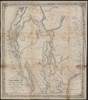
Creator:
Published / Created:
1849
Call Number:
844 1849G
Container / Volume:
BRBL_00601
Image Count:
1
Resource Type:
Maps, Atlases & Globes
Description:
"Entered according to act of Congress in the year 1849 by J.H. Colton in the clerk's office of the district court for the southern district of New York."
Publisher:
J.H. Colton,
Subject (Geographic):
California--Maps and West (U.S.)--Maps
Subject (Name):
Ackerman Lithr and D. Appleton and Company
Found in:
Beinecke Rare Book and Manuscript Library > Map of California, Oregon, Texas, and the territories adjoining, with routes &c.
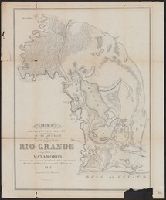
Creator:
Published / Created:
1847
Call Number:
796 R477 1847
Container / Volume:
BRBL_00528
Image Count:
1
Resource Type:
Maps, Atlases & Globes
Alternative Title:
Sen ex Doc I sess 31 Congr. ; No 65 and Senate executive document (United States. Congress. Senate) ; 31st Congress, 1st session, no. 65.
Description:
North oriented toward lower right.
Publisher:
s.n.],
Subject (Geographic):
Mexican-American Border Region--Maps, Rio Grande--Maps, and Texas--Maps
Subject (Name):
Abert, John James, 1788-1863, Ackerman Lithr, Mullorony, T. E, and United States. Army. Corps of Topographical Engineers
Found in:
Beinecke Rare Book and Manuscript Library > Map of the country adjacent to the left bank of the Rio Grande below Matamoros / surveyed under instructions from Col. J.J. Abert, Corps Top. Eng.rs. ; made by Lieut. J.D. Webster, J.E. ; assisted by T.E. Mullorony, Esq.r. ; Ackerman's Lith.
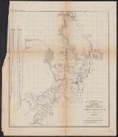
Creator:
Published / Created:
1853?]
Call Number:
818 1853
Container / Volume:
BRBL_00565
Image Count:
2
Resource Type:
Maps, Atlases & Globes
Description:
"Also a continuation of the emigrant road from Fort Smith and Fulton down the valley of the Gila."
Publisher:
War Dept.?,
Subject (Geographic):
Southwestern States--Discovery and exploration--Maps and United States--Discovery and exploration--Maps
Subject (Name):
Ackerman Lithr and United States. War Dept
Found in:
Beinecke Rare Book and Manuscript Library > Map of the country between the frontiers of Arkansas and New Mexico : embracing the section explored in 1849, 50, 51, & 52 / by R.B. Marcy, under orders from the War Department.
Creator:
Published / Created:
1853, 1854.
Call Number:
792 1855C
Container / Volume:
BRBL_00518
Image Count:
1
Resource Type:
Maps, Atlases & Globes
Publisher:
Army Topographic Engineers],
Subject (Name):
Ackerman Lithr, Bryan, F.T, and Drake, A.E
Subject (Topic):
Canals--Florida--Maps and Surveys--Florida--Maps
Found in:
Beinecke Rare Book and Manuscript Library > Map showing the different lines of survey across Florida for a canal between Espiritu Santo Bay and the St. Johns and Ocklawaha Rivers / by Lieut. M. L. Smith, Topog. Engrs., Lieut. F. T. Bryan, Topog. Engrs. and A. E. Drake, C. Engr.
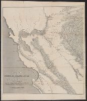
Published / Created:
1855-6]
Call Number:
80 1855C
Container / Volume:
BRBL_00534
Image Count:
1
Resource Type:
Maps, Atlases & Globes
Alternative Title:
Senate ex. doc. ; no. 1, 1st session, 34th Congress and Senate executive document (United States. Congress. Senate) ; 34th Congress, 1st session, no. 1.
Description:
Indicates routes of Capt. Ingalls, Col. Steptoe, and Lt. Mowry, and camping grounds.
Publisher:
s.n.,
Subject (Geographic):
California--Discovery and exploration--Maps, Utah--Discovery and exploration--Maps, and West (U.S.)--Discovery and exploration--Maps
Subject (Name):
Ackerman Lithr
Found in:
Beinecke Rare Book and Manuscript Library > Map showing the different routes travelled over by the detachments of the Overland Command in the spring of 1855 : from Salt Lake City, Utah, to the Bay of San Francisco.
Creator:
Published / Created:
1850]
Call Number:
844gfc 1849
Container / Volume:
BRBL_00615
Image Count:
1
Resource Type:
Maps, Atlases & Globes
Alternative Title:
House executive document (United States. Congress. House) ; 31st Congress, 1st session, no. 17. and Map of General Riley's route, 1849.
Description:
Appears in U.S. 31st Cong., 1st Sess., 1850, House Ex. Doc. no. 17. Message to the President.
Publisher:
U.S. Congress,
Subject (Geographic):
California, Northern--Maps, California--Gold discoveries--Maps, and San Francisco Bay Area (Calif.)--Maps
Subject (Name):
Ackerman Lithr, Beinecke, Carrie Sperry--Bookplate, Beinecke, Frederick W.--Bookplate, Hollingsworth, John McHenry, 1823-1889, and Riley, Bennett,--1787-1853
Subject (Topic):
Gold mines and mining--California--Maps and Mines and mineral resources--California, Northern--Maps
Found in:
Beinecke Rare Book and Manuscript Library > Sketch of General Riley's route through the mining districts : [of California] July and Aug. 1849 / copied from the original sketch by Lt. Derby in the office of the 10t. Military Dept. by J.Mc.H. Hollingsworth, Asst.