Skip to search
Skip to main content
Skip to first result
Search
You Searched For
Subject (Name)
Bowles, Thomas, -1767
Search Results
Creator:
Published / Created:
17--?]
Call Number:
70 1770
Container / Volume:
BRBL_00356
Image Count:
1
Resource Type:
Maps, Atlases & Globes
Description:
Includes text and ill.
Publisher:
s.n.,
Subject (Geographic):
America--Maps--Early works to 1800
Subject (Name):
Anville, Jean Baptiste Bourguignon d', 1697-1782, Bayly, J, Bellin, Jacques Nicolas, 1703-1772, and Bowles, Thomas, -1767
Found in:
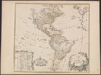
Beinecke Rare Book and Manuscript Library > A map of the whole continent of America : according to D'Anville & Bellin / by L. Delarochette ; Bayly, sculpt.
Creator:
Published / Created:
1715
Call Number:
755 1715C
Container / Volume:
BRBL_00425
Image Count:
1
Resource Type:
Maps, Atlases & Globes
Alternative Title:
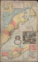
[South part of Carolina, and the east part of Florida], Draught of ye town and harbour of Charles-town, Map of the improved part of Carolina with the settlements, Map of the principal part of North America, and View of ye industry of ye beavers of Canada
Description:
Hand colored.
Publisher:
Printed and sold by Tho. Bowles ...,
Subject (Geographic):
France--Colonies--America--Maps--Early works to 1800, Great Britain--Colonies--America--Maps--Early works to 1800, North America--Maps--Early works to 1800, and United States--History--Colonial period, ca. 1600-1775--Maps--Ear
Subject (Name):
Bowles, John, 1701-1779 and Bowles, Thomas, -1767
Found in:
Beinecke Rare Book and Manuscript Library > A new and exact map of the dominions of the King of Great Britain on ye continent of North America [cartographic material] : containing Newfoundland, New Scotland, New England, New York, New Jersey, Pensilvania, Maryland, Virginia and Carolina according t
Creator:
Published / Created:
1714
Call Number:
40 1714
Container / Volume:
BRBL_00196
Image Count:
1
Resource Type:
Maps, Atlases & Globes
Description:
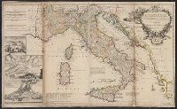
"Note: the post roads in this map are taken from Iacobo Cantelli da Vignola the Duke of Modena's geographer."
Publisher:
printed for H. Moll...Ino. Bowles...T. Bowles...Philip Overton,
Subject (Geographic):
Italy--Maps--Early works to 1800 and Mediterranean Region--Maps--Early works to 1800
Subject (Name):
Bowles, John, 1701-1779, Bowles, Thomas, -1767, Cantelli da Vignola, Giacomo, 1643-1719, and Overton, Philip, -1751
Found in:
Beinecke Rare Book and Manuscript Library > A new map of Italy : distinguishing all the sovereignties in it, whether states, kingdoms, dutchies, principalities, republicks &c. With the post roads, and many remarks not extant in any map. According to ye newest and most exact observations / by H. Mol
Creator:
Published / Created:
[between 1750 and 1769?]
Call Number:
71 1755B
Container / Volume:
BRBL_00363
Image Count:
1
Resource Type:
Maps, Atlases & Globes
Description:
Dates inferred from similarity to variants dated c.1750 and c.1760 in Tooley's Mapping of America, p. 47 and 91.
Publisher:
John Bowles and Son in Cornhil :, printed for T. Bowles in St. Pauls Church yard :, and Robt. Sayer in Fleet Street,
Subject (Geographic):
North America--Maps--Early works to 1800
Subject (Name):
Bowles, John, 1701-1779, Bowles, Thomas, -1767, and Sayer, Robert, 1725-1794
Found in:
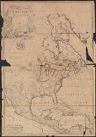
Beinecke Rare Book and Manuscript Library > North America : corrected from the observations communicated to the Royal Society at London and the Royal Academy at Paris / by John Senex F.R.S., 1710.
Creator:
Published / Created:
[between 1750 and 1769?]
Call Number:
71 1755B
Container / Volume:
BRBL_00363
Image Count:
1
Resource Type:
Maps, Atlases & Globes
Description:
Dates inferred from similarity to variants dated c.1750 and c.1760 in Tooley's Mapping of America, p. 47 and 91.
Publisher:
John Bowles and Son in Cornhil :, printed for T. Bowles in St. Pauls Church yard :, and Robt. Sayer in Fleet Street,
Subject (Geographic):
North America--Maps--Early works to 1800
Subject (Name):
Bowles, John, 1701-1779, Bowles, Thomas, -1767, and Sayer, Robert, 1725-1794
Found in:
Beinecke Rare Book and Manuscript Library > North America : corrected from the observations communicated to the Royal Society at London and the Royal Academy at Paris / by John Senex F.R.S., 1710.
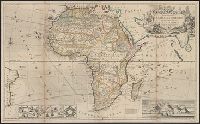
Creator:
Published / Created:
[1710]
Call Number:
60 1708
Container / Volume:
BRBL_00322
Image Count:
1
Resource Type:
Maps, Atlases & Globes
Alternative Title:
This map of Africa
Description:
"According to the newest and most exact observations."
Publisher:
Printed for H. Moll over against Devereux Court without Temple Bar, D. Midwinter at the 3 Crowns in St. Pauls church yard and Tho. Bowles print and mapseller next to the chapter house in St. Pauls church yard by Philip Overton, map and printseller near St
Subject (Geographic):
Africa--Maps--Early works to 1800
Subject (Name):
Bowles, Thomas, -1767, Midwinter, Daniel, active 1698-1725, and Overton, Philip, -1751
Found in:
Beinecke Rare Book and Manuscript Library > To the right honourable Charles, Earl of Peterborow and Monmouth, &c this map of Africa ... is most humbly dedicated / by your Lordship's humble servant H: Moll geographer.