Search
You Searched For
Search Results
- Creator:
- Helm, Charles J
- Published / Created:
- 1906
- Call Number:
- 848 1906
- Container / Volume:
- BRBL_00630
- Image Count:
- 1
- Resource Type:
- Maps, Atlases & Globes
- Description:
- Insets: Aleutian Islands, Sitka, Juneau, Nome.
- Publisher:
- General Land Office,
- Subject (Geographic):
- Alaska--Maps
- Subject (Name):
- Andrew B. Graham Co, Bond, Frank, 1856-1940, Hendges, M, and United States. General Land Office
- Found in:
- Beinecke Rare Book and Manuscript Library > Alaska / compiled from the official records of the General Land Office, U.S. Coast and Geodetic Survey, Geological Survey, Canadian and other sources, under the direction of Frank Bond ; compiled by M. Hendges ; revised and drawn by Charles J. Helm.
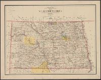
- Creator:
- United States. General Land Office
- Published / Created:
- 1903
- Call Number:
- 822 1903
- Container / Volume:
- BRBL_00567
- Image Count:
- 1
- Resource Type:
- Maps, Atlases & Globes
- Description:
- Relief shown by shading.
- Publisher:
- Dept. of the Interior, General Land Office,
- Subject (Geographic):
- North Dakota--Maps
- Subject (Name):
- Bauman, Wm. (William), Bond, Frank, 1856-1940, and Hendges, M
- Found in:
- Beinecke Rare Book and Manuscript Library > Map of the state of North Dakota / compiled from the official records of the General Land Office and other sources under the direction of Frank Bond ; compiled and drawn by M. Hendges ; lettered by Wm. Bauman, Jr.
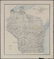
- Creator:
- United States. General Land Office
- Published / Created:
- 1896
- Call Number:
- 812 1896
- Container / Volume:
- BRBL_00555A
- Image Count:
- 1
- Resource Type:
- Maps, Atlases & Globes
- Description:
- "Department of the Interior General Land Office Hon. S.W. Lamoreux, Commissioner."
- Publisher:
- General Land Office,
- Subject (Geographic):
- Wisconsin--Administrative and political divisions--Maps and Wisconsin--Maps
- Subject (Name):
- Friedenwald Co, Hendges, M, and King, Harry (Harold G. R.)
- Found in:
- Beinecke Rare Book and Manuscript Library > Map of the state of Wisconsin / Department of the Interior, General Land Office ; compiled from the official records of the General Land Office and other sources under the direction of Harry King, C.E., chief of Drafting Division G.L.O. ; compiled, drawn
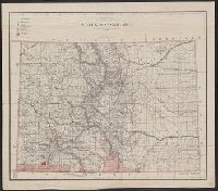
- Creator:
- United States. General Land Office
- Published / Created:
- 1885
- Call Number:
- 834 1885
- Container / Volume:
- BRBL_00587
- Image Count:
- 1
- Resource Type:
- Maps, Atlases & Globes
- Description:
- Compiled and drawn by M. Hendges.
- Publisher:
- Julius Bien & Co.,
- Subject (Geographic):
- Colorado--Maps
- Subject (Name):
- Hendges, M, Julius Bien & Co, and Strum, G. P. (Gustave P.)
- Found in:
- Beinecke Rare Book and Manuscript Library > State of Colorado : compiled from the official records of the General Land Office and other sources / under the supervision of G.P. Strum, principal draughtsman G.L.O.
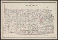
- Creator:
- Berthrong, I. P
- Published / Created:
- 1898
- Call Number:
- 825 1898
- Container / Volume:
- BRBL_00573
- Image Count:
- 1
- Resource Type:
- Maps, Atlases & Globes
- Description:
- Prime meridians: Greenwich and Washington.
- Publisher:
- General Land Office,
- Subject (Geographic):
- Kansas--Maps
- Subject (Name):
- Guggenheimer, Weil & Co, Hendges, M, and United States. General Land Office
- Found in:
- Beinecke Rare Book and Manuscript Library > State of Kansas / compiled from the official records of the General Land Office and other sources under the direction of Harry King ; compiled and drawn by I.P. Berthrong ; revised and corrected to May 1898 by M. Hendges.
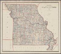
- Creator:
- United States. General Land Office
- Published / Created:
- 1891
- Call Number:
- 816 1891
- Container / Volume:
- BRBL_00561
- Image Count:
- 1
- Resource Type:
- Maps, Atlases & Globes
- Description:
- Compiled, drawn and lettered by M. Hendges.
- Publisher:
- General Land Office,
- Subject (Geographic):
- Missouri--Maps
- Subject (Name):
- Bien Julius, 1829-1909 and Hendges, M
- Found in:
- Beinecke Rare Book and Manuscript Library > State of Missouri / compiled from the official records of the General Land Office, under the supervision of A.F. Dinsmore, Principal Draughtsman.
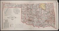
- Creator:
- United States. General Land Office
- Published / Created:
- 1907
- Call Number:
- 827 1907
- Container / Volume:
- BRBL_00577
- Image Count:
- 1
- Resource Type:
- Maps, Atlases & Globes
- Description:
- Includes insets of Guthrie, Muskogee, McAlester, and Lawton.
- Publisher:
- General Land Office?],
- Subject (Geographic):
- Oklahoma--Maps
- Subject (Name):
- Berthrong, I. P, Dinsmore, A. F, Helm, Charles J, and Hendges, M
- Found in:
- Beinecke Rare Book and Manuscript Library > State of Oklahoma / compiled from the official records of the General Land Office and other sources under the direction of I.P. Berthrong ; compiled by A.F. Dinsmore and M. Hendges ; drawn by Charles J. Helm.
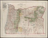
- Creator:
- United States. General Land Office
- Published / Created:
- 1906
- Call Number:
- 846 1906
- Container / Volume:
- BRBL_00621
- Image Count:
- 1
- Resource Type:
- Maps, Atlases & Globes
- Abstract:
- Shows county boundaries, military and Indian reservations, forest reserves, national parks, military roads, and lighthouses.
- Description:
- Gives longitude west from Greenwich and Washington, D.C.
- Publisher:
- The Office,
- Subject (Geographic):
- Oregon--Maps
- Subject (Name):
- Andrew B. Graham Co, Bauman, Wm. (William), Bond, Frank, 1856-1940, Dinsmore, A. F, and Hendges, M
- Found in:
- Beinecke Rare Book and Manuscript Library > State of Oregon / compiled from the official records of the General Land Office and other sources under the direction of Frank Bond ; compiled by M. Hendges ; revised by A.F. Dinsmore ; traced and lettered by Wm. Bauman Jr.
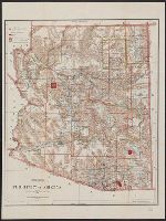
- Creator:
- United States. General Land Office
- Published / Created:
- 1896
- Call Number:
- 842 1896
- Container / Volume:
- BRBL_00598
- Image Count:
- 1
- Resource Type:
- Maps, Atlases & Globes
- Description:
- Prime meridians: Greenwich and Washington.
- Publisher:
- General Land Office,
- Subject (Geographic):
- Arizona--Administrative and political divisions--Maps and Arizona--Maps
- Subject (Name):
- Hendges, M, Morton, Robert H, Norris Peters Co, and Towson, R. M
- Subject (Topic):
- Forest reserves--Arizona--Maps and Indian reservations--Arizona--Maps
- Found in:
- Beinecke Rare Book and Manuscript Library > Territory of Arizona / revised and reconstructed by R.H. Morton ; compiled from the official records of the General Land Office and other sources under supervision of Harry King, C.E. ; lettered by M. Hendges and R.M. Towson.