Search
You Searched For
Search Results
- Creator:
- National Geographic Society (U.S.). Cartographic Division
- Published / Created:
- 1979
- Call Number:
- 738 1979
- Container / Volume:
- BRBL_00387
- Image Count:
- 2
- Resource Type:
- Maps, Atlases & Globes
- Description:
- "Lambert conformal conic projection, standard parallels 51⁰25ʹ and 60⁰55ʹ."
- Publisher:
- The Society,
- Subject (Geographic):
- Manitoba--Maps and Saskatchewan--Maps
- Subject (Name):
- Darley, Richard J and Shupe, John F
- Found in:
- Beinecke Rare Book and Manuscript Library > Close-up, Canada, Saskatchewan and Manitoba / produced by the Cartographic Division, National Geographic Society ; Richard J. Darley, chief cartographer ; John F. Shupe, associate chief cartographer.
- Creator:
- National Geographic Society (U.S.). Cartographic Division
- Published / Created:
- 1986
- Call Number:
- 8101 1986
- Container / Volume:
- BRBL_00552
- Image Count:
- 2
- Resource Type:
- Maps, Atlases & Globes
- Alternative Title:
- Making of America ; no. 13
- Description:
- "Supplement to the National Geographic, December 1986, page 786A, vol. 170, no. 6."
- Publisher:
- The Society,
- Subject (Geographic):
- Great Plains--History--Maps, Great Plains--Maps, Middle West--History--Maps, and Middle West--Maps
- Subject (Name):
- Garver, John B and Shupe, John F
- Found in:
- Beinecke Rare Book and Manuscript Library > Northern Plains / produced by the Cartographic Division, National Geographic Society ... ; John B. Garver, Jr., chief cartographer ; John F. Shupe, associate chief.
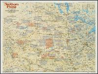
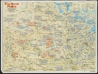
- Creator:
- National Geographic Society (U.S.). Cartographic Division
- Published / Created:
- c1992.
- Call Number:
- 739 1992
- Container / Volume:
- BRBL_00389
- Image Count:
- 2
- Resource Type:
- Maps, Atlases & Globes
- Alternative Title:
- British Columbia.
- Description:
- "Design: Charles W. Berry ; art: Tom NcNeely ; research: Linda R. Kriete, Michael Nicolls, Andrew J. Wahll ..."
- Publisher:
- The Society,
- Subject (Geographic):
- British Columbia--History--Maps
- Subject (Name):
- Shupe, John F
- Found in:
- Beinecke Rare Book and Manuscript Library > The making of Canada. British Columbia / produced by the Cartographic Division, National Geographic Society ; John F. Shupe, chief cartographer.
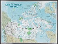
- Creator:
- National Geographic Maps (Firm)
- Published / Created:
- c1997.
- Call Number:
- 741 1997
- Container / Volume:
- BRBL_00395
- Image Count:
- 2
- Resource Type:
- Maps, Atlases & Globes
- Alternative Title:
- Yukon and Northwest Territories
- Description:
- "Supplement to National Geographic, September 1997."
- Publisher:
- National Geographic Society,
- Subject (Geographic):
- Northwest Territories--History--Maps and Yukon--History--Maps
- Subject (Name):
- Carroll, Allen and Shupe, John F
- Found in:
- Beinecke Rare Book and Manuscript Library > The making of Canada. Yukon and Northwest Territories / produced by National Geographic Maps for National Geographic magazine ; Allen Carroll, director of cartography ; John F. Shupe, chief cartographer.