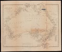
From John Lort Stokes's Discoveries in Australia (1846)., Includes index of counties and notes on explorers and discoveries., Map of Australia showing 19 counties in New South Wales, 26 counties in Western Australia, Eyre's various journeys from Sydney to the Swan River, routes of exploration proposed by Capt. Stokes and coasts examined by H.M.S. Beagle., Relief shown by hachures., and Some borders hand colored.
Publisher:
Pubd. ... by John Arrowsmith, 10 Soho Square,
Subject (Geographic):
Australia--Discovery and exploration--Maps., Australia--Maps, New South Wales, and Western Australia
Subject (Name):
Beagle Expedition--(1831-1836)--Maps. and Stokes, John Lort, 1811-1885. Discoveries in Australia.
Subject (Topic):
Counties--Australia--New South Wales--Maps., Counties--Australia--Western Australia--Maps., and Discoveries in geography
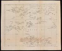
From John Lort Stokes's Discoveries in Australia (1846)., Lower left-hand corner: :Captn Stokes' considers the meridians marked in this Chart to be 2' too far W.", Relief shown by hachures; depth by bathymetric soundings., and Top right-hand corner: "C. Howe bears N. 36* E (Mag) 170 miles from Kent Group."
Publisher:
Pubd ... by John Arrowsmith, 10 Soho Square,
Subject (Geographic):
Bass Strait (Tas. and Vic.)--Discovery and exploration--Maps. and Bass Strait (Tas. and Vic.)--Maps.
Subject (Name):
Arrowsmith, John, 1790-1873, publisher, Beagle (Ship), and Stokes, John Lort, 1811-1885. Discoveries in Australia.
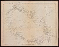
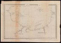
Coordinates not present on map and are approximated., Map of Champion Bay region (now Geraldton) in Western Australia, showing coastal soundings and topography of an area of approx. 250 square miles inland and south to Wizard Peak, centring on Mt. Fairfax. Shows Captain Grey's track and Captain Stokes' track. Relief shown by hachures and spot heights. Depths by soundings., and Originally published in: Discoveries in Australia : with an account of the coasts and rivers explored and surveyed during the voyage of H.M.S. Beagle in the years 1837-43 ... Volume 2 / J. Lort Stokes.
Publisher:
J. Arrowsmith,
Subject (Geographic):
Champion Bay (W.A.)--Maps., Geraldton Region (W.A.)--Discovery and exploration--Maps., and Western Australia--Geraldton Region
Subject (Name):
Beagle (Ship), Grey, George,--1812-1898, Grey, George,--1812-1898--Travel--Australia--Western Australia--Maps., Stokes, John Lort, 1811-1885. Discoveries in Australia., and Stokes, John Lort,--1811-1885--Travel--Australia--Western Australia--Maps.
Subject (Topic):
Discoveries in geography, Nautical charts--Australia--Champion Bay (W.A.), and Voyages and travels
Great Britain. Hydrographic Department, cartographer
Published / Created:
March 23rd 1846.
Call Number:
BrSides 2019 97
Image Count:
1
Resource Type:
Maps, Atlases & Globes
Alternative Title:
Port Adelaide and Holdfast Bay and St. Vincent Gulf, Port Adelaide and Holdfast Bay
Description:
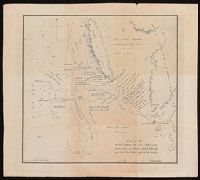
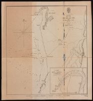
"1752" in lower right corner., Coordinates not present on map and are approximated., From John Lort Stokes's Discoveries in Australia (1846)., Imperfect: mutilated., Inset, Nautical chart of Port Adelaide and Holdfast Bay in South Australia with relief shown by hachures and spot heights. Depth shown by bathymetric soundings., and Port Adelaide enlarged. Scale approximately1: 50,000.
Publisher:
Published according to Act of Parliament at the Hydrographic Office of the Admiralty,
Subject (Geographic):
Brighton (S.A.)--Maps. and Port Adelaide Region (S.A.)--Maps.
Subject (Name):
Bate, R. B. (Robert Brettell), bookseller, J. & C. Walker (Firm), engraver, and Stokes, John Lort, 1811-1885. Discoveries in Australia.
Subject (Topic):
Nautical charts--Australia--Holdfast Bay (S.A. : Bay) and Nautical charts--Australia--Port Adelaide Region (S.A.)