The print reproduces Thomas Hill's painting "Driving the last spike" above a key to seventy-one of the persons represented in the painting; also, a short essay by the historian Richard Dillon
Description:
At foot of sheet: Published by The Nut Tree to commemorate the centennial anniversary of the "Driving of the last spike," Nut Tree, California, 95688.
Publisher:
The Nut Tree
Subject (Geographic):
Utah
Subject (Name):
Central Pacific Railroad Company and Union Pacific Railroad Company
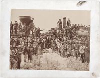
Viewbook of mounted photographic prints compiled by the George W. Williams & Company, fertilizer merchants, ca. 1869. A photographic print appears on the recto of each mount that depicts an advertisement for Carolina Fertilizer with a letterpress testimonial below it. The verso of each mount carries a photographic print of an image created by Andrew J. Russell. The exception is the last mount, which carries a photographic advertisement for BD Sea Fowl Guano on the recto of the mount and no photographic print on the verso. The images by Russell document landscape views and buildings along the Union Pacific Railroad in Nebraska, Wyoming, and Utah, ca. 1867-1869. Many images of landscapes include men and women posited in the terrain to provide scale, An image shows a view of Echo, Utah, as well as rock outcroppings in its vicinity, including Hanging Rock, Monument Rock, and Sphinx Rock, Images of locations in the Weber River Valley, Utah, include views of Coalville city, Devil's Gate, Tunnel No. 4, Bridge No. 32, and of the Mormon Turnpike Bridge at the mouth of the canyon, Images of Wyoming include views of a large windmill at Laramie; Granite Canyon from a water tank; High Bluffs in the Black Buttes area; and an overview of the Laramie River Valley, as well as railroad cuts consisting of the Burning Rock Cut and Hall's Cut (identified in a caption as the Great Mountain Pass)., An image of Omaha, Nebraska, shows a street leading to the Missouri River, An image shows a group of people during the laying of the last rail connecting the Union Pacific Railroad and Central Pacific Railroad on May 10, 1869, near Promontory, Utah, and Sixteen plates without mounted photographic prints in the volume contain graphical advertisements for the products of the George W. Williams Company including BD Sea Fowl Guano, Bradley's Super Phosphate of Lime, C. C. Coe's Ammoniated Super Phosphate of Lime, Carolina Fertilizer, and Palmetto Soluble Acid Phosphate, as well as powdered raw bones and dissolved unburnt bones
Description:
Title from cover., Autograph on front board of Frank E. Taylor., Twenty photographs of the west are reduced images from Andrew J. Russell's, The Great West illustrated . . . New York, 1869., and Photographic prints measure 13 x 7 cm.
Publisher:
s.n.
Subject (Geographic):
United States., West (U.S.), Coalville (Utah), Echo (Utah), Laramie (Wyo.), Missouri River, Nebraska, Omaha (Neb.), Salt Lake City (Utah), Utah, Weber River Valley (Utah), and Wyoming
Subject (Name):
Russell, Andrew J., Williams, George Walton, 1820-1903., Young, Brigham, 1801-1877, Beehive House (Salt Lake City, Utah), Central Pacific Railroad Company, Lion House (Salt Lake City, Utah), Tabernacle (Salt Lake City, Utah), and Union Pacific Railroad Company
Subject (Topic):
Homes and haunts, Advertising, Agriculture, Fertilizer industry, and Railroads
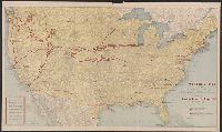
"8-1-17.", On verso: text; ill.; lists of National Army cantonment camps, National Guard concentration camps, increment camps, reserve officers' training camps, aero training stations, posts and stations of the Army, Naval stations and Marine barracks., Relief shown by hachures., and Shows Union Pacific lines connecting camps.
Publisher:
Poole Bros.,
Subject (Name):
Poole Brothers and Union Pacific Railroad Company
Subject (Topic):
Military training camps--United States--Maps and World War, 1914-1918--United States
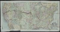
Lists general superintendents and general passenger and ticket agents for Union Pacific Railroad Company and Central Pacific Railroad Company., Relief shown by hachures., and Shows Union Pacific-Central Pacific transcontinental railroad, its land grants, other railroads, proposed railroads, and stage routes.
Publisher:
Rand, McNally & Co.,
Subject (Name):
Central Pacific Railroad Company, Central Pacific Railroad Company--Maps, Union Pacific Railroad Company, and Union Pacific Railroad Company--Maps
Subject (Topic):
Railroad land grants--West (U.S.)--Maps, Railroads--United States--Maps, and Railroads--West (U.S.)--Maps
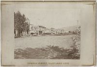
Photographic prints of images created by Andrew Joseph Russell of locations in Utah, Wyoming, California, and Nebraska, ca. 1867-1869. The bound album contains the same images represented in the loose photographic prints. the loose photographic prints were previously bound in a deteriorating leather album with spine title "Views in Salt Lake." The loose photographic prints were foliated before the album was disbound album, Images of locations and structures related to Brigham Young in Utah include views of his residences, known as the Beehive House and Lion House in Salt Lake City; one of these images includes the foundation for the Salt Lake Temple in the foreground. Images of other structures related to Young include his bathhouse located at Warm Sulphur Springs, Salt Lake City, and a view of his cotton and woolen mills in Parley Canyon with the Wasatch Range in the distance, Images of locations in Salt Lake City, Utah, include views of the Tabernacle, the Salt Lake Theatre, Zion's Cooperative Mercantile Institution, and an overview of Temple Street that shows businesses, Images of locations in Echo, Utah, and its vicinity include an overview of the city from the south, as well as several rock formations, including Conglomerate Peaks, Hanging Rock, Sentinel Rock, and Sphinx Rock, Images of locations in Echo Canyon, Utah, and its vicinity include views of several rock outcroppings, including Death's Rock, Finger Rock, and Rock Great Eastern. Several images document Tunnel No. 2 (also known as Echo Tunnel or Wahsatch No. 2) for the Union Pacific Railroad Company, and includes an image of a tunnel entrance, Images of the Weber River and Weber Canyon (also known as the Weber River Valley or Weber Valley), Utah, include views of Coalville; a location on the river near Heneferville (which became Henefer); a vista from Witch Rocks; construction of a wooden bridge across the Weber River at Devil's Gate; a view of Devil's Gate without a bridge; and a view from a ridge of the canyon that shows both entrances to Tunnel No. 3 and two railroad bridges. An image also documents the One Thousand Mile Tree, located in the canyon at a distance one thousand miles west of Omaha, Nebraska, Views of Wilhelmina Pass in Weber Canyon (also known as the Narrows of Weber Canyon), include a distant view of Serrated Rocks (also known as Devil's Slide); a view below a railroad bridge, and an overview of the canyon, Images of locations in the Uinta Mountains, Utah, include a view of Moore's Lake at the head of the Bear River; a view of a man identified as the old trapper in camp beside the Bear River; and a view of the Lake of the Sounding Shore, Images of other locations in Utah include a view of a wooden trestle near Promontory, and a view of Ripple Lake in White Pine Canyon near Park City, Images of locations in the vicinity of Dale Creek, near Sherman and the Laramie Mountains in Wyoming include a view of the Dale Creek Trestle, a wooden railroad trestle bridge; a view of Medicine Bow Mountain; a view of Skull Rock near Sherman Station; a view of Camel Rocks (also known as Granite Rock) near Buford; a view of Devil's Gate in the canyon of Dale Creek; a view of Grizzly Peak from near Evans' Pass; and a view of the source of the Laramie River in the Laramie Mountains, Images of the Green River Valley in Wyoming include a view of the Green River Bridge, a wooden bridge across the Green River with Citadel Rock in the distance; as well as discrete views of rock outcroppings, including Smith's Buttes and Castle Rock, Images of rock outcroppings at various locations throughout Wyoming include views of the High Bluffs near Black Buttes; Church Buttes near Fort Bridger; and Dial Rock in the Laramie Basin, Images of locations in Nebraska include views of a wooden bridge that crosses the North Platte River at its junction with the South Platte River east of the city of North Platte, and a view of the Loup Fork Bridge across Loup Fork of the Platte River, and Images of California include a view from a summit of the Sierra Nevada mountain range with snow sheds in the foreground and Donner Lake in the distance, as well as a view of hydraulic gold mining near Dutch Flat that shows men using jets of water to break down gravel banks
Description:
Title devised by cataloger., Letterpress captions on mounts., Many duplicate images. Some of these photographs also appear in A.J. Russell's The Great West Illustrated . . . New York, 1869., and Accompanied by a box list.
Subject (Geographic):
Utah, Salt Lake City., West (U.S.), Bear River (Utah-Idaho), Buford (Wyo.), California, Coalville (Utah), Dale Creek (Colo. and Wyo.), Donner Lake (Calif.), Dutch Flat (Calif.), Echo (Utah), Echo Canyon (Utah), Green River (Wyo.-Utah), Green River Valley (Wyo.-Utah), Grizzly Peak (Wyo.), Henefer (Utah), Laramie Basin (Wyo.), Laramie Mountains (Colo. and Wyo.), Laramie River (Colo. and Wyo.), Nebraska, North Platte River, One Thousand Mile Tree (Utah : Tree), Parley Canyon (Utah), Platte River (Neb.), Promontory (Utah), Salt Lake City (Utah), Sherman (Wyo.), Sierra Nevada (Calif. and Nev.), Temple Street (Salt Lake City, Utah), Uinta Mountains (Utah and Wyo.), Wasatch Range (Utah and Idaho), Weber River (Utah), Weber River Valley (Utah), White Pine Canyon (Summit County, Utah), Wilhelmina Pass (Utah), Witch Rocks (Utah), and Wyoming
Subject (Name):
Russell, Andrew J., Young, Brigham, 1801-1877, Beehive House (Salt Lake City, Utah), Lion House (Salt Lake City, Utah), Salt Lake Theatre, Tabernacle (Salt Lake City, Utah), Union Pacific Railroad Company, and Zion's Co-operative Mercantile Institution
Subject (Topic):
Homes and haunts, Bridges, Wooden, Hot springs, and Railroads
Crofutts trans-continental tourists guide ... over the Union Pacific railroad, Central Pacific
Container / Volume:
5th vol., and 4th annual revise
Image Count:
1
Resource Type:
Books, Journals & Pamphlets
Abstract:
The joining of the First Transcontinental Railroad, likely based on the photograph taken by Andrew J. Russell of the ceremony of the driving of the golden spike at Promontory Summit, Utah, May 10, 1869.
Description:
Wood engraving signed: Baker
Subject (Geographic):
West (U.S.)--Guidebooks
Subject (Name):
Central Pacific Railroad Company and Union Pacific Railroad Company