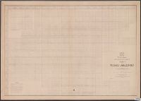
1.

- Creator:
- Maury, Matthew Fontaine, 1806-1873
- Published / Created:
- 1853 [i.e. 1857]
- Call Number:
- 11cfk 1850C-2
- Container / Volume:
- BRBL_00770
- Image Count:
- 2
- Resource Type:
- Maps, Atlases & Globes
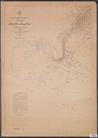
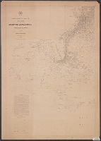
- Alternative Title:
- North Atlantic
- Description:
- "Series C." and The pilot charts were released as series C of Maury's "Wind and current charts", series A-F. These charts were designed for sailing ships and recorded wind direction observations made by mariners on previous voyages. For complete discussion, s
- Publisher:
- United States Hydrographical Office,
- Subject (Geographic):
- North Atlantic Ocean--Maps
- Subject (Name):
- Brooke, John M. (John Mercer), 1826-1906, McClelland, D, United States. Bureau of Ordnance and Hydrography, and United States. Hydrographic Office
- Subject (Topic):
- Nautical charts--North Atlantic Ocean and Winds--North Atlantic Ocean--Maps
- Found in:
- Beinecke Rare Book and Manuscript Library > Pilot chart of the North Atlantic [cartographic material] / by M.F. Maury, L.L.D. Lieut. U.S. Navy ; superint'dt. of U.S.N. Observatory, Washington ; compiled from materials in the Bureau of Ordnance and Hydrography.