Skip to search
Skip to main content
Skip to first result
Search
You Searched For
Subject (Topic)
Coasts
Search Results
Call Number:
1975 Folio 14
Collection Title:
The Atlantic Neptune, published for the use of the Royal Navy of Great Britain. By Joseph F.W. Des
Image Count:
1
Resource Type:
Books, Journals & Pamphlets
Alternative Title:
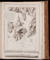
Egmont Harbor. pl. 21.
Publisher:
Published according to Act of parliament by J.F.W. Des Barres
Subject (Geographic):
North America
Subject (Topic):
Charts, diagrams, etc., Coasts, and Nautical charts.
Collection Created:
London, 1777-[81]
Found in:
Beinecke Rare Book and Manuscript Library > ...There is good and well sheltered anchorage without the harbor between Isle James and Isle Worth. Banks inlet leaves between the extensive dry flats at its entrance but a narrow and winding passage for the smallest fishing craft
Call Number:
1975 Folio 14
Collection Title:
The Atlantic Neptune, published for the use of the Royal Navy of Great Britain. By Joseph F.W. Des
Image Count:
1
Resource Type:
Books, Journals & Pamphlets
Alternative Title:
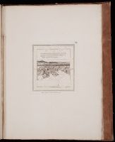
Crow harbor or the south shore of Chedabuctou Bay, pl. 29.
Publisher:
Published according to Act of parliament by J.F.W. Des Barres
Subject (Geographic):
Chedabucto Bay (N.S.), North America., and Nova Scotia
Subject (Topic):
Charts, diagrams, etc., Coasts, and Nautical charts.
Collection Created:
London, 1777-[81]
Found in:
Beinecke Rare Book and Manuscript Library > ...banks inlet leaves between the extensive dry flats at its entrance but a narrow and winding passage for the smallest fishing craft
Creator:
Published / Created:
1766. NB. With a book of directions.
Call Number:
2003 Folio 85
Image Count:
1
Description:
BEIN 2003 Folio 85: Without book of directions mentioned after publisher statement. No. 10 of 45 maps bound together with binder's spine title: Atlas of America; ms. table of contents. Bookplate: Robinson. Bookplate of Paul Mellon.
Publisher:
Published ... by James Cook, and sold by I. Mount and T. Page ... Tho's. Jeffrey ... and And'w. Dury ... London
Subject (Geographic):
Newfoundland and Labrador
Subject (Topic):
Coasts and Nautical charts
Found in:
Beinecke Rare Book and Manuscript Library > A chart of part of the south coast of Newfoundland : including the islands St. Peters and Miquelon : from an actual survey taken by order of Commodore Pallisser, Governor of Newfoundland, Labrador, &c.
Creator:
Published / Created:
June 17th, 1780.
Call Number:
1982 Folio 10
Image Count:
1
Description:
BEIN 1982 Folio 10: Armorial bookplate: Charles Abbot. No. 8 of 42 maps bound together.
Publisher:
Engraved & published by W. Faden
Subject (Geographic):
North Sea, English Channel, France, England, and Biscay, Bay of (France and Spain)
Subject (Topic):
Nautical charts, Coasts, and Navigation
Found in:
Beinecke Rare Book and Manuscript Library > A chart of the British Channel and the Bay of Biscay with a part of the North Sea, and the entrance of St. George's Channel
Creator:
Published / Created:
June 28th, 1780.
Call Number:
1982 Folio 10
Image Count:
1
Description:
BEIN 1982 Folio 10: Armorial bookplate: Charles Abbot. No. 13 of 42 maps bound together.
Publisher:
Engraved & published by Wm. Faden
Subject (Geographic):
Spain, Portugal, Africa, North, and Mediterranean Sea
Subject (Topic):
Nautical charts and Coasts
Found in:
Beinecke Rare Book and Manuscript Library > A chart of the coasts of Spain and Portugal, with the Balearic Islands, and part of the coast of Barbary
Creator:
Published / Created:
Jany. 1st, 1781.
Call Number:
1982 Folio 10
Image Count:
1
Description:
BEIN 1982 Folio 10: Armorial bookplate: Charles Abbot. No. 9 of 42 maps bound together.
Publisher:
W. Faden
Subject (Geographic):
Channel Islands, France, Brittany, Normandy, Brittany (France), and Normandy (France)
Subject (Topic):
Nautical charts and Coasts
Found in:
Beinecke Rare Book and Manuscript Library > A chart of the islands of Jersey and Guernsey, Sark, Herm and Alderney, with the adjacent coast of France
Creator:
Published / Created:
Decem'r. 1766.
Call Number:
2003 Folio 85
Image Count:
1
Description:
BEIN 2003 Folio 85: No. 15 of 45 maps bound together with binder's spine title: Atlas of America; ms. table of contents. Bookplate: Robinson. Bookplate of Paul Mellon.
Publisher:
Published by the author according to Act of Parliament
Subject (Geographic):
Nova Scotia and Halifax (N.S.)
Subject (Topic):
Coasts and Nautical charts
Found in:
Beinecke Rare Book and Manuscript Library > A draught of the harbour of Halifax and the adjacent coast in Nova Scotia : surveyed by order of Commodore Spry
Creator:
Published / Created:
December 1766.
Call Number:
2003 Folio 85
Image Count:
1
Description:
BEIN 2003 Folio 85: No. 26 of 45 maps bound together with binder's spine title: Atlas of America; ms. table of contents. Bookplate: Robinson. Bookplate of Paul Mellon.
Publisher:
Published by the author according to Act of Parliament
Subject (Geographic):
Florida
Subject (Topic):
Coasts and Nautical charts
Found in:
Beinecke Rare Book and Manuscript Library > A draught of west Florida : with part of the river Mississippi
Creator:
Published / Created:
[169-?]
Call Number:
1973 Folio 10
Image Count:
1
Description:
BEIN 1973 Folio 10: Sheet measures 61.2 x 52 cm. Bookplate of José M. Rodriguez. No. 6 of 63 maps bound together.
Publisher:
Printed and sold by Chr. Brown at the Globe in St. Pauls Church Yard
Subject (Geographic):
France, Northern, English Channel, and England, Southern
Subject (Topic):
Coasts
Found in:
Beinecke Rare Book and Manuscript Library > A new chart of the sea coasts of France : together with the English Chanell describing ye severall harbors, sands, rocks, and anchoridges &c. on the said coasts
Creator:
Published / Created:
[ca. 1700]
Call Number:
1973 Folio 10
Image Count:
1
Alternative Title:
New map of the sea coasts of England, Scotland, and Ireland
Description:
BEIN 1973 Folio 10: Sheet measures 52 x 61.2 cm. Bookplate of José M. Rodriguez. No. 3 of 63 maps bound together.
Publisher:
Sold by Robert Morden at the Atlas in Cornhill and by Christopher Brown at the Globe in St. Paul's Church Yard
Subject (Geographic):
Great Britain and North Sea
Subject (Topic):
Coasts
Found in:
Beinecke Rare Book and Manuscript Library > A new mapp of the sea coasts of England, Scotland, and Ireland : with the adjacent coasts of France, Holand, Denmark & Norway, shewing the scituation and distance of the several ports, harbors, havens, creeks, sands &c.