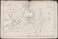
Depths shown by soundings., In lower right margin: Prix trente sols., In upper right margin: No. 1 (Hyd. No. 57)., Includes table and notes., and Prime meridian: Paris.
Publisher:
Dépôt Général des Cartes, Plans et Journaux de la Marine,
Subject (Geographic):
Maritime Provinces--Maps--Early works to 1800, Newfoundland and Labrador--Maps--Early works to 1800, and Saint Lawrence, Gulf of--Maps--Early works to 1800
Subject (Topic):
Coasts--Maritime Provinces--Maps--Early works to 1800, Coasts--Newfoundland and Labrador--Maps--Early works to 1800, Nautical charts--Grand Banks of Newfoundland--Early works to 1800, and Nautical charts--Maritime Provinces--E
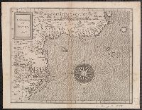
Appears in the author's Descriptionis Ptolemaicae augmentum. 1597., Covers the Atlantic coast of North America from Nova Scotia to Virginia., Has watermark., In upper right: 17., and Relief shown pictorially.
Publisher:
J. Bogard],
Subject (Geographic):
Atlantic Coast (U.S.)--Maps--Early works to 1800
Subject (Name):
Bogard, Jean, d. ca. 1634 and Wytfliet, Corneille. Descriptionis Ptolemaicae augmentum
Subject (Topic):
Coasts--Maritime Provinces--Maps--Early works to 1800