Search
You Searched For
Search Results
- Creator:
- Great Britain. Hydrographic Office
- Published / Created:
- [1871]
- Call Number:
- 7391 1871
- Container / Volume:
- BRBL_00394
- Image Count:
- 1
- Resource Type:
- Maps, Atlases & Globes
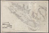
- Description:
- "Juan de Fuca Strait from Capt. Henry Kellett's survey of 1847. Shores of Washington Territory from the United States Coast Survey."
- Publisher:
- The Admiralty,
- Subject (Geographic):
- Vancouver Island (B.C.)--Maps
- Subject (Name):
- Arnold, Robert M.--Ownership, Davies & Powell, Mayne, R. C, Powell, E. J, and Richards, G. H. (George Henry)
- Subject (Topic):
- Coasts--British Columbia--Maps and Coasts--Washington (State)--Maps
- Found in:
- Beinecke Rare Book and Manuscript Library > Vancouver Island and adjacent shores of British Columbia / surveyed by G.H. Richards, assisted by R.C. Mayne ... [et al.], 1859-65 ; compiled and drawn for engraving by E.J. Powell ; engraved by Davies & Powell.