
You Searched For
1 - 8 of 8
Search Results
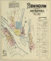
1. Birmingham, Connecticut.
- Creator:
- Sanborn Map & Publishing Co., issuing body
- Published / Created:
- 1886
- Call Number:
- 766 B53 1886
- Image Count:
- 11
- Resource Type:
- Maps, Atlases & Globes
- Abstract:
- Sanborn fire insurance maps are a rich source of historic data on the urban built environment of North America during the 19th and early 20th centuries. The atlases were created for the purpose of underwriting fire insurance policies, which depended upon accurate and frequently-updated information about construction materials, municipal and transportation infrastructure, industrial and commercial landuse and more. The Yale University Library Map Department scanned its holdings of Sanborn fire insurance maps (consisting primarily of Connecticut towns) in order to make the maps more accessible.
- Alternative Title:
- June 1886, Birmingham, Conn.
- Description:
- "11 sheets.", Contains information on population, prevailing winds, water facilities and fire department., Includes index of streets and specials., Includes portion of Shelton., Partial cadastral map., and SMLMAPL 766 B53 1886: Sheets disbound. "Triplicate" stamp on all sheets. Library of Congress copyright stamp on title sheet.
- Subject (Geographic):
- Derby (Conn.)--Maps and Shelton (Conn.)--Maps
- Subject (Name):
- Library of Congress Stamp
- Subject (Topic):
- Fire risk assessment--Connecticut--Derby--Maps, Fire risk assessment--Connecticut--Shelton--Maps, Real property--Connecticut--Derby--Maps, and Real property--Connecticut--Shelton--Maps
- Found in:
- Beinecke Rare Book and Manuscript Library > Birmingham, Connecticut.

2. Birmingham, including Shelton and Derby Narrows, Connecticut.
- Creator:
- Sanborn-Perris Map Co., issuing body
- Published / Created:
- 1892
- Call Number:
- 766 B53 1892
- Image Count:
- 14
- Resource Type:
- Maps, Atlases & Globes
- Abstract:
- Sanborn fire insurance maps are a rich source of historic data on the urban built environment of North America during the 19th and early 20th centuries. The atlases were created for the purpose of underwriting fire insurance policies, which depended upon accurate and frequently-updated information about construction materials, municipal and transportation infrastructure, industrial and commercial landuse and more. The Yale University Library Map Department scanned its holdings of Sanborn fire insurance maps (consisting primarily of Connecticut towns) in order to make the maps more accessible.
- Alternative Title:
- Birmingham, Conn. and June 1892, Birmingham, Conn.
- Description:
- "14 sheets (5311).", Contains information on population, prevailing winds, water facilities and fire department., Includes index of streets and specials., Partial cadastral map., and SMLMAPL 766 B53 1892: Sheets disbound. "Triplicate" stamp on all sheets.
- Subject (Geographic):
- Derby (Conn.)--Maps and Shelton (Conn.)--Maps
- Subject (Topic):
- Fire risk assessment--Connecticut--Derby--Maps, Fire risk assessment--Connecticut--Shelton--Maps, Real property--Connecticut--Derby--Maps, and Real property--Connecticut--Shelton--Maps
- Found in:
- Beinecke Rare Book and Manuscript Library > Birmingham, including Shelton and Derby Narrows, Connecticut.
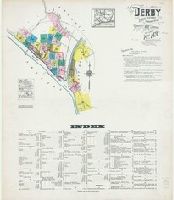
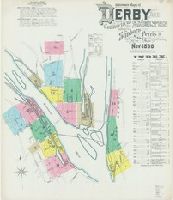
3. Derby, Conn.
- Creator:
- Sanborn Map & Publishing Co., issuing body
- Published / Created:
- 1885
- Call Number:
- 766 D444 1885
- Image Count:
- 1
- Resource Type:
- Maps, Atlases & Globes
- Abstract:
- Sanborn fire insurance maps are a rich source of historic data on the urban built environment of North America during the 19th and early 20th centuries. The atlases were created for the purpose of underwriting fire insurance policies, which depended upon accurate and frequently-updated information about construction materials, municipal and transportation infrastructure, industrial and commercial landuse and more. The Yale University Library Map Department scanned its holdings of Sanborn fire insurance maps (consisting primarily of Connecticut towns) in order to make the maps more accessible.
- Description:
- Contains information on population, prevailing winds, water facilities and fire department., Partial cadastral map., and SMLMAPL 766 D444 1885: "Triplicate" stamp and Library of Congress copyright stamp.
- Subject (Geographic):
- Derby (Conn.)--Maps
- Subject (Name):
- Library of Congress Stamp
- Subject (Topic):
- Fire risk assessment--Connecticut--Derby--Maps and Real property--Connecticut--Derby--Maps
- Found in:
- Beinecke Rare Book and Manuscript Library > Derby, Conn.
4. Derby, including East Derby, New Haven County, Connecticut.
- Creator:
- Sanborn Map Company, issuing body
- Published / Created:
- 1924
- Call Number:
- 766 D444 1924
- Image Count:
- 30
- Resource Type:
- Maps, Atlases & Globes
- Abstract:
- Sanborn fire insurance maps are a rich source of historic data on the urban built environment of North America during the 19th and early 20th centuries. The atlases were created for the purpose of underwriting fire insurance policies, which depended upon accurate and frequently-updated information about construction materials, municipal and transportation infrastructure, industrial and commercial landuse and more. The Yale University Library Map Department scanned its holdings of Sanborn fire insurance maps (consisting primarily of Connecticut towns) in order to make the maps more accessible.
- Alternative Title:
- Apr. 1924, Derby, Conn. and Apr. 1924, Derby, Conn. East Derby.
- Description:
- "30 sheets. (1543).", Contains information on population, prevailing winds, water facilities, and fire department., Includes index of streets and specials., Partial cadastral map., Sheets 2-16, 18-25, and 27-29 at scale 1:600; sheets 17, 26, and 30 at scale 1:1,200., and SMLMAPL 766 D444 1924: Sheets disbound. Library of Congress copyright stamp on title sheet.
- Subject (Geographic):
- Derby (Conn.)--Maps
- Subject (Name):
- Library of Congress Stamp
- Subject (Topic):
- Fire risk assessment--Connecticut--Derby--Maps and Real property--Connecticut--Derby--Maps
- Found in:
- Beinecke Rare Book and Manuscript Library > Derby, including East Derby, New Haven County, Connecticut.
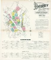
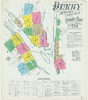
5. Insurance maps of Derby and Shelton, New Haven County, Connecticut.
- Creator:
- Sanborn Map Company, issuing body
- Published / Created:
- 1912
- Call Number:
- 766 D444 1912
- Image Count:
- 22
- Resource Type:
- Maps, Atlases & Globes
- Abstract:
- Sanborn fire insurance maps are a rich source of historic data on the urban built environment of North America during the 19th and early 20th centuries. The atlases were created for the purpose of underwriting fire insurance policies, which depended upon accurate and frequently-updated information about construction materials, municipal and transportation infrastructure, industrial and commercial landuse and more. The Yale University Library Map Department scanned its holdings of Sanborn fire insurance maps (consisting primarily of Connecticut towns) in order to make the maps more accessible.
- Alternative Title:
- Apr. 1912, Derby, Conn., Apr. 1912, Derby, Conn. Shelton., and Derby and Shelton, New Haven County, Connecticut.
- Description:
- "22 sheets. (4763).", Contains information on population, prevailing winds, water facilities, and fire department., Includes index of streets and specials., Partial cadastral map., and SMLMAPL 766 D444 1912: Sheets disbound. Library of Congress copyright stamp on title sheet.
- Subject (Geographic):
- Derby (Conn.)--Maps and Shelton (Conn.)--Maps
- Subject (Name):
- Library of Congress Stamp and Library of Congress. Map Division Stamp
- Subject (Topic):
- Fire risk assessment--Connecticut--Derby--Maps, Fire risk assessment--Connecticut--Shelton--Maps, Real property--Connecticut--Derby--Maps, and Real property--Connecticut--Shelton--Maps
- Found in:
- Beinecke Rare Book and Manuscript Library > Insurance maps of Derby and Shelton, New Haven County, Connecticut.
6. Insurance maps of Derby and Shelton, New Haven County, Fairfield County, Connecticut.
- Creator:
- Sanborn Map Company, issuing body
- Published / Created:
- 1906
- Call Number:
- 766 D444 1906
- Image Count:
- 21
- Resource Type:
- Maps, Atlases & Globes
- Abstract:
- Sanborn fire insurance maps are a rich source of historic data on the urban built environment of North America during the 19th and early 20th centuries. The atlases were created for the purpose of underwriting fire insurance policies, which depended upon accurate and frequently-updated information about construction materials, municipal and transportation infrastructure, industrial and commercial landuse and more. The Yale University Library Map Department scanned its holdings of Sanborn fire insurance maps (consisting primarily of Connecticut towns) in order to make the maps more accessible.
- Alternative Title:
- Derby and Shelton, New Haven County, Fairfield County, Connecticut., Oct. 1906, Derby, Conn., and Oct. 1906, Derby, Conn. Shelton.
- Description:
- "21 sheets. (9020).", Contains information on population, prevailing winds, water facilities, and fire department., Includes index of streets and specials., Partial cadastral map., and SMLMAPL 766 D444 1906: Sheets disbound. "Triplicate" stamp on all sheets. Library of Congress copyright and Map Division stamps on title sheet.
- Subject (Geographic):
- Derby (Conn.)--Maps and Shelton (Conn.)--Maps
- Subject (Name):
- Library of Congress Stamp and Library of Congress. Map Division Stamp
- Subject (Topic):
- Fire risk assessment--Connecticut--Derby--Maps, Fire risk assessment--Connecticut--Shelton--Maps, Real property--Connecticut--Derby--Maps, and Real property--Connecticut--Shelton--Maps
- Found in:
- Beinecke Rare Book and Manuscript Library > Insurance maps of Derby and Shelton, New Haven County, Fairfield County, Connecticut.
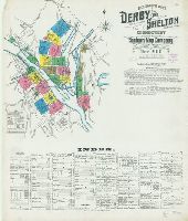
7. Insurance maps of Derby and Shelton, New Haven and Fairfield Co's., Connecticut.
- Creator:
- Sanborn-Perris Map Co., issuing body
- Published / Created:
- 1896
- Call Number:
- 766 D444 1896
- Image Count:
- 15
- Resource Type:
- Maps, Atlases & Globes
- Abstract:
- Sanborn fire insurance maps are a rich source of historic data on the urban built environment of North America during the 19th and early 20th centuries. The atlases were created for the purpose of underwriting fire insurance policies, which depended upon accurate and frequently-updated information about construction materials, municipal and transportation infrastructure, industrial and commercial landuse and more. The Yale University Library Map Department scanned its holdings of Sanborn fire insurance maps (consisting primarily of Connecticut towns) in order to make the maps more accessible.
- Alternative Title:
- Derby and Shelton, New Haven and Fairfield Co's., Connecticut, Nov. 1896, Derby, Conn., Nov. 1896, Derby, Conn. (Shelton)., Nov. 1896, E. Derby, Conn., and Nov. 1896, East Derby, Conn.
- Description:
- "15 sheets. (805).", Contains information on population, prevailing winds, water facilities, and fire department., Includes index of streets and specials., Partial cadastral map., and SMLMAPL 766 D444 1896: Sheets disbound. "Triplicate" stamp on all sheets. Library of Congress copyright stamp on title sheet.
- Subject (Geographic):
- Derby (Conn.)--Maps and Shelton (Conn.)--Maps
- Subject (Name):
- Library of Congress Stamp
- Subject (Topic):
- Fire risk assessment--Connecticut--Derby--Maps, Fire risk assessment--Connecticut--Shelton--Maps, Real property--Connecticut--Derby--Maps, and Real property--Connecticut--Shelton--Maps
- Found in:
- Beinecke Rare Book and Manuscript Library > Insurance maps of Derby and Shelton, New Haven and Fairfield Co's., Connecticut.
8. Insurance maps of Derby and Shelton, New Haven and Fairfield Co's., Connecticut.
- Creator:
- Sanborn-Perris Map Co., issuing body
- Published / Created:
- 1901
- Call Number:
- 766 D444 1901
- Image Count:
- 18
- Resource Type:
- Maps, Atlases & Globes
- Abstract:
- Sanborn fire insurance maps are a rich source of historic data on the urban built environment of North America during the 19th and early 20th centuries. The atlases were created for the purpose of underwriting fire insurance policies, which depended upon accurate and frequently-updated information about construction materials, municipal and transportation infrastructure, industrial and commercial landuse and more. The Yale University Library Map Department scanned its holdings of Sanborn fire insurance maps (consisting primarily of Connecticut towns) in order to make the maps more accessible.
- Alternative Title:
- Derby and Shelton, New Haven and Fairfield Co's., Connecticut, Oct. 1901, Derby, Conn., and Oct. 1901, Derby, Conn. (Shelton).
- Description:
- "18 sheets. (5028).", Contains information on population, prevailing winds, water facilities, and fire department., Includes index of streets and specials., Partial cadastral map., and SMLMAPL 766 D444 1901: Sheets disbound. "Triplicate" stamp on all sheets. Library of Congress copyright stamp on title sheet.
- Subject (Geographic):
- Derby (Conn.)--Maps and Shelton (Conn.)--Maps
- Subject (Name):
- Library of Congress Stamp
- Subject (Topic):
- Fire risk assessment--Connecticut--Derby--Maps, Fire risk assessment--Connecticut--Shelton--Maps, Real property--Connecticut--Derby--Maps, and Real property--Connecticut--Shelton--Maps
- Found in:
- Beinecke Rare Book and Manuscript Library > Insurance maps of Derby and Shelton, New Haven and Fairfield Co's., Connecticut.