

- None3
You Searched For
« Previous
| 1 - 10 of 13 |
Next »
Search Results
2.
- Published / Created:
- 1874-1898.
- Call Number:
- WA Photos Folio 1
- Container / Volume:
- Box 1
- Image Count:
- 32
- Abstract:
- Photographs created from mammoth plate negatives primarily by photographers Carleton E. Watkins and William Henry Jackson of various locations in the American West, primarily in the states of California, Colorado, and Oregon, as well as Arizona, Monta...
- Description:
- A mammoth plate is a photographic negative plate, 18 by 21 inches (53.5 x 45.7 cm.) or larger, from which photographic prints are made through contact printing.
- Subject (Geographic):
- Wyoming, Montana, West (U.S.), Arizona, Arkansas River, Austin Bluffs (Colo.), Black Canyon of the Gunnison (Colo.), Blue Lakes (Calif.), Bridal Veil Falls (Utah), California, Cathedral Rocks (Calif.), Cathedral Spires (El Paso County, Colo.), Cathedral Spires (Jefferson County, Colo.), Clear Creek Canyon (Colo.), Clear Creek County (Colo.), Cochise Stronghold (Ariz.), Colorado, Columbia River, Costilla County (Colo.), Curecanti Needle (Colo.), Dalles (Or.), Dragoon Mountains (Ariz.), Drumlummon Mine (Mont.), Eagle Creek (Or.), Echo (Utah), El Capitan (Calif.), El Paso County (Colo.), Fountain Creek (Colo.), Fremont County (Colo.), Garden of the Gods (Colorado Springs, Colo.), Garfield County (Colo.), Gate Rock (El Paso County, Colo.), Giant Geyser (Wyo.), Glenwood Springs (Colo.), Grotto Geyser (Wyo.), Gunnison County (Colo.), Gunnison River (Colo.), Half Dome (Calif.), Jefferson County (Colo.), Jerome County (Idaho), Lake Vineyard (San Gabriel, Calif.), Marysville (Lewis and Clark County, Mont.), Mokelumne River (Calif.), Monument Park (El Paso County, Colo.), Multnomah County (Or.), Multnomah Creek (Or.), Multnomah Falls (Or.), North Cheyenne Canyon (Colo.), North Cheyenne Creek (Colo.), North Fork American River (Calif.), Old Faithful Geyser (Wyo.), Oregon, Palisades Falls, Pikes Peak (Colo.), Platte Canyon (Colo.), Port Ludlow (Wash.), Port Madison (Bainbridge Island, Wash.), Provo Canyon (Utah), Provo River (Utah), Pulpit Rock (Utah), Pulpit Terrace (Wyo.), Rainbow Falls (Colo.), Rio Arriba County (N.M.), Rio de los Pinos (Colo. and N.M.), Round Top Mountain (Calif.), Royal Gorge (Colo.), San Gabriel (Calif.), Sentinel Rock (Calif.), Seven Falls (Colo.), Sierra Blanca (Colo.), Snake River (Wyo.-Wash.), Soda Springs (Calif.), South Cheyenne Canyon (Colo.), South Cheyenne Creek (Colo.), South Platte River (Colo. and Neb.), Spokane (Wash.), Spokane River (Idaho and Wash.), Teller County (Colo.), Toltec Gorge (N.M.), Tombstone (Ariz.), Tombstone Region (Ariz.), Twin Creek (Colo.), Twin Falls (Idaho : Waterfalls), Utah, Ute Pass (Teller County, Colo.), Washington (State), Yampah Hot Springs (Colo.), Yellowstone National Park, Yosemite National Park (Calif.), and Yosemite Valley (Calif.)
- Subject (Name):
- Haynes, F. Jay 1853-1921. (Frank Jay),, Jackson, William Henry, 1843-1942., Meeker, Ezra, 1830-1928., Watkins, Carleton E., 1829-1916., Colorado Central Railroad Company, Denver and Rio Grande Railroad Company, Denver, South Park, and Pacific Railroad Company, Mission San Gabriel Arcangel (San Gabriel, Calif.), and Tough Nut Mine
- Subject (Topic):
- Geysers, Landscape photography, Mineral industries, and Railroads
- Found in:
- Beinecke Rare Book and Manuscript Library > Mammoth plate photographs of the North American West
3.
- Published / Created:
- 1874-1898.
- Call Number:
- WA Photos Folio 1
- Container / Volume:
- Box 3
- Image Count:
- 28
- Abstract:
- Photographs created from mammoth plate negatives primarily by photographers Carleton E. Watkins and William Henry Jackson of various locations in the American West, primarily in the states of California, Colorado, and Oregon, as well as Arizona, Monta...
- Description:
- A mammoth plate is a photographic negative plate, 18 by 21 inches (53.5 x 45.7 cm.) or larger, from which photographic prints are made through contact printing.
- Subject (Geographic):
- Wyoming, Montana, West (U.S.), Arizona, Arkansas River, Austin Bluffs (Colo.), Black Canyon of the Gunnison (Colo.), Blue Lakes (Calif.), Bridal Veil Falls (Utah), California, Cathedral Rocks (Calif.), Cathedral Spires (El Paso County, Colo.), Cathedral Spires (Jefferson County, Colo.), Clear Creek Canyon (Colo.), Clear Creek County (Colo.), Cochise Stronghold (Ariz.), Colorado, Columbia River, Costilla County (Colo.), Curecanti Needle (Colo.), Dalles (Or.), Dragoon Mountains (Ariz.), Drumlummon Mine (Mont.), Eagle Creek (Or.), Echo (Utah), El Capitan (Calif.), El Paso County (Colo.), Fountain Creek (Colo.), Fremont County (Colo.), Garden of the Gods (Colorado Springs, Colo.), Garfield County (Colo.), Gate Rock (El Paso County, Colo.), Giant Geyser (Wyo.), Glenwood Springs (Colo.), Grotto Geyser (Wyo.), Gunnison County (Colo.), Gunnison River (Colo.), Half Dome (Calif.), Jefferson County (Colo.), Jerome County (Idaho), Lake Vineyard (San Gabriel, Calif.), Marysville (Lewis and Clark County, Mont.), Mokelumne River (Calif.), Monument Park (El Paso County, Colo.), Multnomah County (Or.), Multnomah Creek (Or.), Multnomah Falls (Or.), North Cheyenne Canyon (Colo.), North Cheyenne Creek (Colo.), North Fork American River (Calif.), Old Faithful Geyser (Wyo.), Oregon, Palisades Falls, Pikes Peak (Colo.), Platte Canyon (Colo.), Port Ludlow (Wash.), Port Madison (Bainbridge Island, Wash.), Provo Canyon (Utah), Provo River (Utah), Pulpit Rock (Utah), Pulpit Terrace (Wyo.), Rainbow Falls (Colo.), Rio Arriba County (N.M.), Rio de los Pinos (Colo. and N.M.), Round Top Mountain (Calif.), Royal Gorge (Colo.), San Gabriel (Calif.), Sentinel Rock (Calif.), Seven Falls (Colo.), Sierra Blanca (Colo.), Snake River (Wyo.-Wash.), Soda Springs (Calif.), South Cheyenne Canyon (Colo.), South Cheyenne Creek (Colo.), South Platte River (Colo. and Neb.), Spokane (Wash.), Spokane River (Idaho and Wash.), Teller County (Colo.), Toltec Gorge (N.M.), Tombstone (Ariz.), Tombstone Region (Ariz.), Twin Creek (Colo.), Twin Falls (Idaho : Waterfalls), Utah, Ute Pass (Teller County, Colo.), Washington (State), Yampah Hot Springs (Colo.), Yellowstone National Park, Yosemite National Park (Calif.), and Yosemite Valley (Calif.)
- Subject (Name):
- Haynes, F. Jay 1853-1921. (Frank Jay),, Jackson, William Henry, 1843-1942., Meeker, Ezra, 1830-1928., Watkins, Carleton E., 1829-1916., Colorado Central Railroad Company, Denver and Rio Grande Railroad Company, Denver, South Park, and Pacific Railroad Company, Mission San Gabriel Arcangel (San Gabriel, Calif.), and Tough Nut Mine
- Subject (Topic):
- Geysers, Landscape photography, Mineral industries, and Railroads
- Found in:
- Beinecke Rare Book and Manuscript Library > Mammoth plate photographs of the North American West
4.
- Published / Created:
- 1874-1898.
- Call Number:
- WA Photos Folio 1
- Container / Volume:
- Box 2
- Image Count:
- 26
- Abstract:
- Photographs created from mammoth plate negatives primarily by photographers Carleton E. Watkins and William Henry Jackson of various locations in the American West, primarily in the states of California, Colorado, and Oregon, as well as Arizona, Monta...
- Description:
- A mammoth plate is a photographic negative plate, 18 by 21 inches (53.5 x 45.7 cm.) or larger, from which photographic prints are made through contact printing.
- Subject (Geographic):
- Wyoming, Montana, West (U.S.), Arizona, Arkansas River, Austin Bluffs (Colo.), Black Canyon of the Gunnison (Colo.), Blue Lakes (Calif.), Bridal Veil Falls (Utah), California, Cathedral Rocks (Calif.), Cathedral Spires (El Paso County, Colo.), Cathedral Spires (Jefferson County, Colo.), Clear Creek Canyon (Colo.), Clear Creek County (Colo.), Cochise Stronghold (Ariz.), Colorado, Columbia River, Costilla County (Colo.), Curecanti Needle (Colo.), Dalles (Or.), Dragoon Mountains (Ariz.), Drumlummon Mine (Mont.), Eagle Creek (Or.), Echo (Utah), El Capitan (Calif.), El Paso County (Colo.), Fountain Creek (Colo.), Fremont County (Colo.), Garden of the Gods (Colorado Springs, Colo.), Garfield County (Colo.), Gate Rock (El Paso County, Colo.), Giant Geyser (Wyo.), Glenwood Springs (Colo.), Grotto Geyser (Wyo.), Gunnison County (Colo.), Gunnison River (Colo.), Half Dome (Calif.), Jefferson County (Colo.), Jerome County (Idaho), Lake Vineyard (San Gabriel, Calif.), Marysville (Lewis and Clark County, Mont.), Mokelumne River (Calif.), Monument Park (El Paso County, Colo.), Multnomah County (Or.), Multnomah Creek (Or.), Multnomah Falls (Or.), North Cheyenne Canyon (Colo.), North Cheyenne Creek (Colo.), North Fork American River (Calif.), Old Faithful Geyser (Wyo.), Oregon, Palisades Falls, Pikes Peak (Colo.), Platte Canyon (Colo.), Port Ludlow (Wash.), Port Madison (Bainbridge Island, Wash.), Provo Canyon (Utah), Provo River (Utah), Pulpit Rock (Utah), Pulpit Terrace (Wyo.), Rainbow Falls (Colo.), Rio Arriba County (N.M.), Rio de los Pinos (Colo. and N.M.), Round Top Mountain (Calif.), Royal Gorge (Colo.), San Gabriel (Calif.), Sentinel Rock (Calif.), Seven Falls (Colo.), Sierra Blanca (Colo.), Snake River (Wyo.-Wash.), Soda Springs (Calif.), South Cheyenne Canyon (Colo.), South Cheyenne Creek (Colo.), South Platte River (Colo. and Neb.), Spokane (Wash.), Spokane River (Idaho and Wash.), Teller County (Colo.), Toltec Gorge (N.M.), Tombstone (Ariz.), Tombstone Region (Ariz.), Twin Creek (Colo.), Twin Falls (Idaho : Waterfalls), Utah, Ute Pass (Teller County, Colo.), Washington (State), Yampah Hot Springs (Colo.), Yellowstone National Park, Yosemite National Park (Calif.), and Yosemite Valley (Calif.)
- Subject (Name):
- Haynes, F. Jay 1853-1921. (Frank Jay),, Jackson, William Henry, 1843-1942., Meeker, Ezra, 1830-1928., Watkins, Carleton E., 1829-1916., Colorado Central Railroad Company, Denver and Rio Grande Railroad Company, Denver, South Park, and Pacific Railroad Company, Mission San Gabriel Arcangel (San Gabriel, Calif.), and Tough Nut Mine
- Subject (Topic):
- Geysers, Landscape photography, Mineral industries, and Railroads
- Found in:
- Beinecke Rare Book and Manuscript Library > Mammoth plate photographs of the North American West
5.
- Published / Created:
- 1874-1898.
- Call Number:
- WA Photos Folio 1
- Container / Volume:
- Box 4
- Image Count:
- 28
- Abstract:
- Photographs created from mammoth plate negatives primarily by photographers Carleton E. Watkins and William Henry Jackson of various locations in the American West, primarily in the states of California, Colorado, and Oregon, as well as Arizona, Monta...
- Description:
- A mammoth plate is a photographic negative plate, 18 by 21 inches (53.5 x 45.7 cm.) or larger, from which photographic prints are made through contact printing.
- Subject (Geographic):
- Wyoming, Montana, West (U.S.), Arizona, Arkansas River, Austin Bluffs (Colo.), Black Canyon of the Gunnison (Colo.), Blue Lakes (Calif.), Bridal Veil Falls (Utah), California, Cathedral Rocks (Calif.), Cathedral Spires (El Paso County, Colo.), Cathedral Spires (Jefferson County, Colo.), Clear Creek Canyon (Colo.), Clear Creek County (Colo.), Cochise Stronghold (Ariz.), Colorado, Columbia River, Costilla County (Colo.), Curecanti Needle (Colo.), Dalles (Or.), Dragoon Mountains (Ariz.), Drumlummon Mine (Mont.), Eagle Creek (Or.), Echo (Utah), El Capitan (Calif.), El Paso County (Colo.), Fountain Creek (Colo.), Fremont County (Colo.), Garden of the Gods (Colorado Springs, Colo.), Garfield County (Colo.), Gate Rock (El Paso County, Colo.), Giant Geyser (Wyo.), Glenwood Springs (Colo.), Grotto Geyser (Wyo.), Gunnison County (Colo.), Gunnison River (Colo.), Half Dome (Calif.), Jefferson County (Colo.), Jerome County (Idaho), Lake Vineyard (San Gabriel, Calif.), Marysville (Lewis and Clark County, Mont.), Mokelumne River (Calif.), Monument Park (El Paso County, Colo.), Multnomah County (Or.), Multnomah Creek (Or.), Multnomah Falls (Or.), North Cheyenne Canyon (Colo.), North Cheyenne Creek (Colo.), North Fork American River (Calif.), Old Faithful Geyser (Wyo.), Oregon, Palisades Falls, Pikes Peak (Colo.), Platte Canyon (Colo.), Port Ludlow (Wash.), Port Madison (Bainbridge Island, Wash.), Provo Canyon (Utah), Provo River (Utah), Pulpit Rock (Utah), Pulpit Terrace (Wyo.), Rainbow Falls (Colo.), Rio Arriba County (N.M.), Rio de los Pinos (Colo. and N.M.), Round Top Mountain (Calif.), Royal Gorge (Colo.), San Gabriel (Calif.), Sentinel Rock (Calif.), Seven Falls (Colo.), Sierra Blanca (Colo.), Snake River (Wyo.-Wash.), Soda Springs (Calif.), South Cheyenne Canyon (Colo.), South Cheyenne Creek (Colo.), South Platte River (Colo. and Neb.), Spokane (Wash.), Spokane River (Idaho and Wash.), Teller County (Colo.), Toltec Gorge (N.M.), Tombstone (Ariz.), Tombstone Region (Ariz.), Twin Creek (Colo.), Twin Falls (Idaho : Waterfalls), Utah, Ute Pass (Teller County, Colo.), Washington (State), Yampah Hot Springs (Colo.), Yellowstone National Park, Yosemite National Park (Calif.), and Yosemite Valley (Calif.)
- Subject (Name):
- Haynes, F. Jay 1853-1921. (Frank Jay),, Jackson, William Henry, 1843-1942., Meeker, Ezra, 1830-1928., Watkins, Carleton E., 1829-1916., Colorado Central Railroad Company, Denver and Rio Grande Railroad Company, Denver, South Park, and Pacific Railroad Company, Mission San Gabriel Arcangel (San Gabriel, Calif.), and Tough Nut Mine
- Subject (Topic):
- Geysers, Landscape photography, Mineral industries, and Railroads
- Found in:
- Beinecke Rare Book and Manuscript Library > Mammoth plate photographs of the North American West
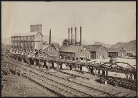
6.

- Creator:
- Watkins, Carleton E., 1829-1916
- Published / Created:
- 1861-1868.
- Call Number:
- WA Photos Folio 19
- Image Count:
- 5
- Abstract:
- Mammoth-plate photographs of California, including views in Yosemite of Half Dome, North Dome, the Royal Arches, Washington Column, Cathedral Rock, the Cathedral Spires, Mount Broderick, Mount Starr King, Nevada Fall, the Bridal Veil, the Yosemite Fal...
- Description:
- Carleton E. Watkins was a San Francisco photographer who worked both with official surveys and independently to photograph California, Nevada and Utah. In 1867 he served with Clarence King as the official photographer to the California Geological Sur...
- Subject (Geographic):
- California, Yosemite Valley (Calif.), and San Francisco (Calif.)
- Subject (Name):
- New Almaden Quicksilver Mines (Calif.)
- Subject (Topic):
- Mineral industries
- Found in:
- Beinecke Rare Book and Manuscript Library > Mammoth-plate photographs of California [graphic].
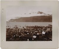
7.
- Creator:
- Watkins, Carleton E., 1829-1916
- Published / Created:
- ca. 1875.
- Call Number:
- WA Photos Folio 20
- Image Count:
- 2
- Abstract:
- Mammoth-plate photographs of Gold Hill and Virginia City in the Comstock region of Nevada, showing the Consolidated Virginia Battery Mill and Hoisting Works in Virginia City, the Ophir hoisting works, and a view of town of Gold Hill from the Wheeler m...
- Description:
- Manuscript captions and numbers on verso.
- Subject (Geographic):
- Nevada, Gold Hill (Nev.), and Virginia City (Nev.)
- Subject (Topic):
- Mineral industries
- Found in:
- Beinecke Rare Book and Manuscript Library > Mammoth-plate photographs of Gold Hill and Virginia City, Nevada [graphic].
8.
- Creator:
- La Roche, Frank, 1853-1934
- Published / Created:
- ca. 1892.
- Call Number:
- WA Photos 98
- Image Count:
- 20
- Abstract:
- Photographs of Alaskan cities and scenery, including views in Sitka of the Greek Church and Russian Block House, street scenes in Juneau, the Treadwell Mill and Mine, totems at Fort Wrangell, the Indian River, Muir and Takou Glaciers, and of the Steam...
- Description:
- Photographs are mounted on both sides of ten boards, with manuscript or letterpress captions.
- Publisher:
- La Roche, Photo
- Subject (Geographic):
- Treadwell Mine, Alaska, Sitka (Alaska), Juneau (Alaska), Muir Glacier (Alaska), and Wrangell (Alaska)
- Subject (Topic):
- Mineral industries, Chilkat Indians, Indians of North America, Musicians, and Totem poles
- Found in:
- Beinecke Rare Book and Manuscript Library > Photographs of Alaska [graphic].
9.
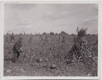
- Creator:
- Jackson, William Henry, 1843-1942
- Published / Created:
- ca. 1897-1924.
- Call Number:
- WA Photos 5
- Image Count:
- 26
- Abstract:
- Photographs of South Dakota farming scenes, Montana and Dakota Badlands landscapes, and the Moonlight, Bell, and Clark's Smelter mining operations in Butte, Montana. Photographs taken by William Henry Jackson, probably before 1900, and published by th...
- Description:
- Accompanied by a box list.
- Publisher:
- Detroit Publishing Co. or Detroit Photographic Co.
- Subject (Geographic):
- Montana, South Dakota, Badlands (N.D.), and Butte (Mont.)
- Subject (Topic):
- Mineral industries, Farms, and Coaching (Transportation)
- Found in:
- Beinecke Rare Book and Manuscript Library > Photographs of Montana and South Dakota [graphic].
10.

- Published / Created:
- 1916.
- Call Number:
- WA Photos 50
- Image Count:
- 54
- Abstract:
- Snapshot photographs of the construction of the Stoddard Mine, including views of buildings and workers and of machinery at the mine, such as the bin, the tram, the head frame and the mine hoist
- Description:
- Individual prints are 7.0 x 4.8 cm. or smaller. Several have brief captions inscribed in the negatives. Photographs were mounted on paper and enclosed in clear plastic "album" by a later owner.
- Subject (Name):
- Stoddard Mine.
- Subject (Topic):
- Mineral industries
- Found in:
- Beinecke Rare Book and Manuscript Library > Photographs of the construction of the Stoddard Mine [graphic].