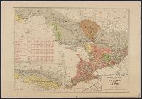
Shows proposed railroads primarily in the North Central United States and Canada; bullseye centering on Mackinaw City and the Great Lakes region and the Straits of Mackinaw connecting Lake Michigan and Lake Huron; Michigan counties, major cities and t...
Publisher:
Middleton, Strobridge & Co.,
Subject (Geographic):
Canada--Maps, Great Lakes (North America)--Maps, and Middle West--Maps
Subject (Name):
Canadian Pacific Railway Company--Maps and Northern Pacific Railroad Company--Maps
Subject (Topic):
Counties--Michigan--Maps, Mines and mineral resources--Canada--Maps, Railroads--Canada--Maps, and Railroads--Great Lakes (North America)--Maps
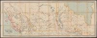
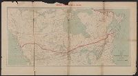
Includes inset showing railway across all of Canada, "Map of the Canadian Pacific Railway, (Pacific Division) and connections on the Pacific Coast," and time tables.
Canadian Pacific Railway Company, Duluth, South Shore, and Atlantic Railway Company, Duluth, South Shore, and Atlantic Railway Company--Maps, and Spokane International Railway--Maps
Subject (Topic):
Railroads--Canada--Maps and Railroads--United States--Maps
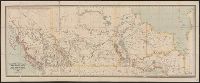
Sportsman's map of Canada and the Northwest Territory.
Description:
Date taken from Yale card catalog indicating map was originally in cover with date of issue, March 1901; also with a cover title, "The sportsman's map of Canada and the Northwest Territory."
Publisher:
Poole Bros.,
Subject (Geographic):
Canada--Maps and United States--Maps
Subject (Name):
Canadian Pacific Railway Company, Canadian Pacific Railway Company--Maps, Duluth, South Shore, and Atlantic Railway Company, and Duluth, South Shore, and Atlantic Railway Company--Maps
Subject (Topic):
Railroads--Canada--Maps and Railroads--United States--Maps
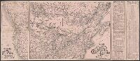
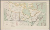
Includes distances from Montreal to other cities in Canada, costs of railways operations in 1907, mileage operated in 1907 and "Railway mileage by provinces, 1907."