Skip to search
Skip to main content
Skip to first result
Search
You Searched For
Subject (Topic)
Railroads--Colorado--Maps
Search Results
Creator:
Published / Created:
1868
Call Number:
834gme 1868
Container / Volume:
BRBL_00591
Image Count:
1
Resource Type:
Maps, Atlases & Globes
Description:
Bookplate: ex libris T W S [i.e. Thomas Winthrop Streeter].
Publisher:
Chicago Lithographing Co.,
Subject (Name):
Chicago Lithographing Co, Denver Pacific Railway and Telegraph Company, Denver Pacific Railway and Telegraph Company--Maps, and Streeter, Thomas W.--(Thomas Winthrop),--1883-1965--Bookplate
Subject (Topic):
Railroads--Colorado--Maps
Found in:
Beinecke Rare Book and Manuscript Library > Denver Pacific Railway map showing the final location with prospective connections : compiled from railroad and gov't. surveys / F.M. Case.
Published / Created:
1881?]
Call Number:
834gme 1881
Container / Volume:
BRBL_00591
Image Count:
2
Resource Type:
Maps, Atlases & Globes
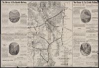
Alternative Title:
Denver and Rio Grande Railway
Description:
Also shows route to northern New Mexico.
Publisher:
American Bank Note Co.?,
Subject (Name):
American Bank Note Company, Denver and Rio Grande Railway Company, and Denver and Rio Grande Railway Company--Maps
Subject (Topic):
Railroads--Colorado--Maps
Found in:
Beinecke Rare Book and Manuscript Library > Map of the Denver and Rio Grande Railway : showing stage lines and all principal mining camps and pleasure resorts in Colorado.
Creator:
Published / Created:
1891
Call Number:
834 1891
Container / Volume:
BRBL_00587
Image Count:
1
Resource Type:
Maps, Atlases & Globes
Alternative Title:
Colorado and Rand, McNally & Co.'s new business atlas map of Colorado.
Description:
"Rand, McNally & Co.'s New Business Atlas Map of Colorado. Copyright 1890, by Rand, McNally & Co."
Publisher:
The Co.,
Subject (Geographic):
Colorado--Maps
Subject (Topic):
Railroads--Colorado--Maps
Found in:
Beinecke Rare Book and Manuscript Library > Rand, McNally & Co.'s Colorado.
Creator:
Published / Created:
1893
Call Number:
834 1893A
Container / Volume:
BRBL_00588
Image Count:
1
Resource Type:
Maps, Atlases & Globes
Alternative Title:
Colorado and Rand, McNally & Co.'s new business atlas map of Colorado.
Description:
"Rand, McNally & Co.'s New Business Atlas Map of Colorado. Copyright 1890, by Rand, McNally & Co."
Publisher:
Rand McNally,
Subject (Geographic):
Colorado--Maps
Subject (Topic):
Railroads--Colorado--Maps
Found in:
Beinecke Rare Book and Manuscript Library > Rand, McNally & Co.'s Colorado.
Creator:
Published / Created:
1895
Call Number:
834 1895
Container / Volume:
BRBL_00588
Image Count:
1
Resource Type:
Maps, Atlases & Globes
Alternative Title:
Colorado and Rand, McNally & Co.'s new business atlas map of Colorado.
Description:
"Rand, McNally & Co.'s New Business Atlas Map of Colorado. Copyright 1890, by Rand, McNally & Co."
Publisher:
Rand McNally,
Subject (Geographic):
Colorado--Maps
Subject (Topic):
Railroads--Colorado--Maps
Found in:
Beinecke Rare Book and Manuscript Library > Rand, McNally & Co.'s Colorado.