Skip to search
Skip to main content
Skip to first result
Search
You Searched For
Subject (Topic)
Railroads--Massachusetts--Maps
Search Results
Creator:
Published / Created:
1866, c1860.
Call Number:
753 1866C
Container / Volume:
BRBL_00415
Image Count:
1
Resource Type:
Maps, Atlases & Globes
Alternative Title:
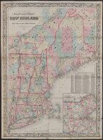
Railroad, township & distance map of New England and Railroad, township and distance map of New England
Description:
Area includes all of New England and parts of New York State, Quebec and New Brunswick.
Publisher:
G.W. and C.B. Colton & Co.,
Subject (Geographic):
Massachusetts--Maps and New England--Maps
Subject (Name):
G.W. & C.B. Colton & Co
Subject (Topic):
Railroads--Massachusetts--Maps and Railroads--New England--Maps
Found in:
Beinecke Rare Book and Manuscript Library > G. Woolworth Colton's railroad, township & distance map of New England : with adjacent portions of New York, Canada & New Brunswick.
Creator:
Published / Created:
1868
Call Number:
771 1868A
Container / Volume:
BRBL_00479
Image Count:
1
Resource Type:
Maps, Atlases & Globes
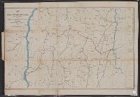
Description:
Covers areas of N.Y., Conn., and Mass. surrounding their intersection.
Publisher:
H.H. Lloyd & Co.'s Map Establishment,
Subject (Geographic):
Connecticut--Maps, Massachusetts--Maps, and New York (State)--Maps
Subject (Name):
Connecticut Western Railroad Co.--Maps and Dutchess and Columbia Railroad Co.--Maps
Subject (Topic):
Railroads--Connecticut--Maps, Railroads--Massachusetts--Maps, and Railroads--New York (State)--Maps
Found in:
Beinecke Rare Book and Manuscript Library > Map of portions of New York and New England showing the routes of the Dutchess and Columbia & Connecticut Western Rail Roads / Oliver W. Barnes.
Creator:
Published / Created:
1850
Call Number:
764gme 1850
Container / Volume:
BRBL_00462
Image Count:
1
Resource Type:
Maps, Atlases & Globes
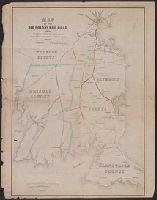
Abstract:
Map of eastern Massachusetts covering the area from Boston to Wood's Hole and west to Providence, R.I. Shows drainage, place names and counties, and indicates mileage between stations. The Old Colony Railroad is double-tracked from Boston, south to So...
Description:
Description derived from published bibliography.
Subject (Name):
Old Colony Railroad Company and Old Colony Railroad Company--Maps
Subject (Topic):
Railroads--Massachusetts--Maps
Found in:
Beinecke Rare Book and Manuscript Library > Map of the Old Colony Rail Road with its branches & connecting roads, prepared under the direction of the Committee of Investigation, Jany. 1850, S. Dwight Eaton, Engr.
Creator:
Published / Created:
1882
Call Number:
764gme 1882
Container / Volume:
BRBL_00462
Image Count:
1
Resource Type:
Maps, Atlases & Globes
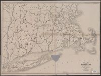
Description:
Shows railroads in Massachusetts and their continuation into neighboring states.
Publisher:
Rand, Avery & Co. Engravers and Printers,
Subject (Geographic):
Massachusetts--Maps
Subject (Topic):
Railroads--Massachusetts--Maps
Found in:
Beinecke Rare Book and Manuscript Library > Map of the railroads of the state of Massachusetts : accompanying the report of the Railroad Commissioners.
Creator:
Published / Created:
1874
Call Number:
764gme 1874
Container / Volume:
BRBL_00462
Image Count:
1
Resource Type:
Maps, Atlases & Globes
Description:
"Scale, Six Miles to the Inch."
Publisher:
The Board,
Subject (Geographic):
Massachusetts--Maps
Subject (Topic):
Railroads--Connecticut--Maps, Railroads--Hudson River Valley (N.Y. and N.J.)--Maps, Railroads--Massachusetts--Maps, Railroads--New York (State)--Long Island--Maps, and Railroads--Rhode Island--Maps
Found in:
Beinecke Rare Book and Manuscript Library > Map of the railroads of the state of Massachusetts : accompanying the report of the railroad commissioners. 1874.
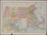
Creator:
Published / Created:
[1911]
Call Number:
764 1911
Container / Volume:
BRBL_00453
Image Count:
1
Resource Type:
Maps, Atlases & Globes
Description:
Includes index to counties and principal cities, list of Massachusetts railroads, and steamship routes.
Publisher:
Rand McNally & Co.,
Subject (Geographic):
Massachusetts--Maps
Subject (Topic):
Railroads--Massachusetts--Maps and Roads--Massachusetts--Maps
Found in:
Beinecke Rare Book and Manuscript Library > Massachusetts.
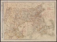
Creator:
Published / Created:
[1921]
Call Number:
764 1921
Container / Volume:
BRBL_00453
Image Count:
2
Resource Type:
Maps, Atlases & Globes
Alternative Title:
Standard map of Massachusetts
Description:
Includes index to counties and principal cities, list of Massachusetts railroads, and steamship routes.
Publisher:
Rand McNally & Co.,
Subject (Geographic):
Massachusetts--Maps
Subject (Topic):
Railroads--Massachusetts--Maps and Roads--Massachusetts--Maps
Found in:
Beinecke Rare Book and Manuscript Library > Rand McNally standard map of Massachusetts.