Skip to search
Skip to main content
Skip to first result
Search
You Searched For
Subject (Topic)
Railroads--Middle West--Maps
Search Results
Creator:
Published / Created:
1859
Call Number:
754gme 1859
Container / Volume:
BRBL_00420
Image Count:
1
Resource Type:
Maps, Atlases & Globes
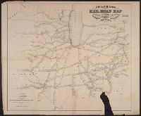
Abstract:
Outline map showing the railroad network and stations along the rail lines. [From published bibliography].
Description:
"Chas. Shober Lith. 109 Lake St. Chicago."
Publisher:
S. Chapman,
Subject (Topic):
Railroads--Middle West--Maps
Found in:
Beinecke Rare Book and Manuscript Library > Chapman's rail road map of Ohio, Indiana, Michigan, Illinois, Missouri, Minnesota, & Wisconsin.
Creator:
Published / Created:
1883
Call Number:
80gme 1883
Container / Volume:
BRBL_00539
Image Count:
1
Resource Type:
Maps, Atlases & Globes
Alternative Title:
Chicago, Burlington and Quincy R.R.
Description:
Covers lands in Middle West.
Publisher:
Rand McNally,
Subject (Name):
Chicago, Burlington & Quincy Railroad Company--Maps
Subject (Topic):
Railroads--Middle West--Maps
Found in:
Beinecke Rare Book and Manuscript Library > Chicago, Burlington & Quincy R.R., and intersecting lines.
Creator:
Published / Created:
1899
Call Number:
80gme 1899
Container / Volume:
BRBL_00539
Image Count:
1
Resource Type:
Maps, Atlases & Globes
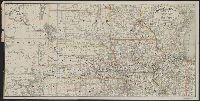
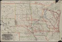
Alternative Title:
Chicago, Burlington and Quincy railroad system
Description:
Covers area from Colorado to Lake Michigan, through South Dakota, Minnesota, Wisconsin, Nebraska, Iowa, Illinois, and northern Kansas and Missouri.
Publisher:
Rand McNally & Co.,
Subject (Name):
Chicago, Burlington & Quincy Railroad Company and Chicago, Burlington & Quincy Railroad Company--Maps
Subject (Topic):
Railroads--Middle West--Maps and Railroads--West (U.S.)--Maps
Found in:
Beinecke Rare Book and Manuscript Library > Chicago, Burlington & Quincy railroad system.
Creator:
Published / Created:
1872
Call Number:
80gme 1872
Container / Volume:
BRBL_00539
Image Count:
1
Resource Type:
Maps, Atlases & Globes
Alternative Title:
Railroad and express map of the northwestern states :
Description:
Covers lands from Minnesota and Wisconsin to southern Kansas, Missouri, and Illinois.
Publisher:
G.W. & C.B. Colton,
Subject (Topic):
Railroads--Middle West--Maps
Found in:
Beinecke Rare Book and Manuscript Library > Colton's railroad and express map of the northwestern states : showing the counties, towns, railroads, station, distances, etc.
Creator:
Published / Created:
1871?]
Call Number:
80gme 1871
Container / Volume:
BRBL_00538
Image Count:
1
Resource Type:
Maps, Atlases & Globes
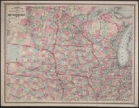
Alternative Title:
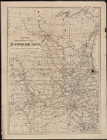
Map of the Burlington and Southwestern Railway:
Description:
Shows lines running from Chicago and Logansport, Ind. through Iowa and Missouri into Nebraska, Kansas, and "Indian Territory."
Publisher:
Gaylord Watson?,
Subject (Name):
Burlington and Southwestern Railway--Maps
Subject (Topic):
Railroads--Middle West--Maps
Found in:
Beinecke Rare Book and Manuscript Library > Map of the Burlington and South Western Railway : and connections / prepared at Gaylord Watson's map establishment, 16 Beckman St., N.Y.
Creator:
Published / Created:
1904
Call Number:
80gme 1904
Container / Volume:
BRBL_00540
Image Count:
1
Resource Type:
Maps, Atlases & Globes
Description:
Relief shown by hachures.
Publisher:
Rand McNally,
Subject (Name):
Chicago and North Western Railway Company--Maps and Chicago, St. Paul, Minneapolis & Omaha Railroad--Maps
Subject (Topic):
Railroads--Middle West--Maps
Found in:
Beinecke Rare Book and Manuscript Library > Map of the Chicago & North Western Railway and the Chicago, St. Paul, Minneapolis & Omaha Railway.
Published / Created:
1900?]
Call Number:
80gme 1900
Container / Volume:
BRBL_00540
Image Count:
1
Resource Type:
Maps, Atlases & Globes
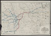
Description:
Covers area from Colorado to Illinois, through Nebraska, Iowa, Kansas, and Missouri.
Publisher:
Shober & Carqueville?,
Subject (Name):
Chicago, Burlington & Quincy Railroad Company--Maps and Shober & Carqueville
Subject (Topic):
Railroads--Middle West--Maps
Found in:
Beinecke Rare Book and Manuscript Library > Map of the Chicago, Burlington and Quincy R.R. and its connections.
Creator:
Published / Created:
1858
Call Number:
754gme 1858
Container / Volume:
BRBL_00420
Image Count:
1
Resource Type:
Maps, Atlases & Globes
Description:
"Entered according to Act of Congress in the year 1858, by J.H. Colton & Co., in the Clerk's Office of the District Court for Southern District of New York."
Publisher:
J.H. Colton & Co.,
Subject (Geographic):
Middle West--Maps. and United States--Maps
Subject (Name):
Streeter, Thomas W.--(Thomas Winthrop),--1883-1965--Stamp.
Subject (Topic):
Railroads--Middle West--Maps and Railroads--United States--Maps
Found in:
Beinecke Rare Book and Manuscript Library > Map of the Mississippi and Missouri Railroad : and its connections.
Creator:
Published / Created:
1875
Call Number:
80 1875B
Container / Volume:
BRBL_00535
Image Count:
1
Resource Type:
Maps, Atlases & Globes
Alternative Title:
New commercial county and rail road map of the north-western states and Watson's new commercial county and railroad map of the north-western states
Description:
"Entered according to act of Congress in the year 1874 by Gaylord Watson in the office of the librarian of Congress."
Publisher:
Gaylord Watson],
Subject (Geographic):
Middle West--Administrative and political divisions--Maps and Middle West--Maps
Subject (Topic):
Railroads--Middle West--Maps
Found in:
Beinecke Rare Book and Manuscript Library > Watson's new commercial county and rail road map of the north-western states.