Skip to search
Skip to main content
Skip to first result
Search
You Searched For
Subject (Topic)
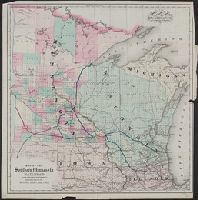
Railroads--Minnesota--Maps
Search Results
Creator:
Published / Created:
[between 1857 and 1877?]
Call Number:
80gme 1877
Container / Volume:
BRBL_00539
Image Count:
1
Resource Type:
Maps, Atlases & Globes
Description:
Company changed name to Southern Minnesota Railroad Company in 1857; reorg. 1877 as Southern Minnesota Railway Company (source: LC auth. record).
Publisher:
G.W. & C.B. Colton,
Subject (Name):
Southern Minnesota Railroad Company--Maps
Subject (Topic):
Railroads--Minnesota--Maps and Railroads--Wisconsin--Maps
Found in:
Beinecke Rare Book and Manuscript Library > Map of the Southern Minnesota Railroad and its connections.
Published / Created:
1891]
Call Number:
814gme 1891
Container / Volume:
BRBL_00559
Image Count:
1
Resource Type:
Maps, Atlases & Globes
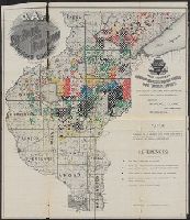
Description:
Includes text.
Publisher:
s.n.,
Subject (Name):
H.M. Smyth Printing Company (Saint Paul, Minn.), Martin, Ralph, engraver, and St. Paul & Duluth Railroad Company--Maps
Subject (Topic):
Railroad land grants--Minnesota--Maps and Railroads--Minnesota--Maps
Found in:
Beinecke Rare Book and Manuscript Library > Map showing lands belonging to the St. Paul and Duluth Railroad Company, June 30th 1891 / Ralph Martin, del.
Published / Created:
1900]
Call Number:
814ad 1900
Container / Volume:
BRBL_00559
Image Count:
2
Resource Type:
Maps, Atlases & Globes
Alternative Title:
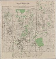
Sectional land map showing land for sale by the Northern Pacific Railway Company, in Aitkin, Cass, Crow Wing, Hubbard, Itasca, Mille Lacs, Morrison, Todd and Wadena counties in central Minnesota, the ideal place for diversified farming, dairying, and mark
Description:
"Issued by the Land Department, W.H. Phipps, Land Commissioner, St. Paul, Minnesota."
Publisher:
s.n.,
Subject (Name):
Northern Pacific Railway Company. Land Dept and Northern Pacific Railway Company--Maps
Subject (Topic):
Railroad land grants--Minnesota--Maps and Railroads--Minnesota--Maps
Found in:
Beinecke Rare Book and Manuscript Library > Map showing lands for sale by the land department of the Northern Pacific Railway Co. in Hubbard, Wadena, Todd, Aitkin, Cass, Crow-Wing, Mille Lacs, and Itasca counties, Minnesota.
Creator:
Published / Created:
1911
Call Number:
814 1911
Container / Volume:
BRBL_00557
Image Count:
1
Resource Type:
Maps, Atlases & Globes
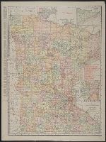
Abstract:
Shows railroads and counties.
Description:
Includes indexes and insets of "N.E. corner of Minnesota, showing Cook County" and "Minneapolis, St. Paul and vicinity."
Publisher:
Rand, McNally & Co.,
Subject (Geographic):
Minnesota--Maps
Subject (Topic):
Railroads--Minnesota--Maps
Found in:
Beinecke Rare Book and Manuscript Library > Minnesota.
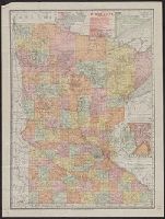
Creator:
Published / Created:
1908
Call Number:
814gme 1908
Container / Volume:
BRBL_00559
Image Count:
2
Resource Type:
Maps, Atlases & Globes
Description:
Includes index to railroads, and insets of Cook County and Minneapolis-St. Paul vicinity.
Publisher:
Rand McNally,
Subject (Geographic):
Minnesota--Maps
Subject (Topic):
Railroads--Minnesota--Maps
Found in:
Beinecke Rare Book and Manuscript Library > Minnesota.
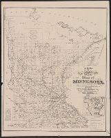
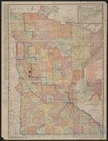
Creator:
Published / Created:
1878
Call Number:
814gme 1878
Container / Volume:
BRBL_00559
Image Count:
1
Resource Type:
Maps, Atlases & Globes
Description:
"Published for the State Board of Immigration."
Publisher:
Merchants Lithographing and Printing Co.,
Subject (Geographic):
Minnesota--Maps
Subject (Name):
Merchants Lithographing & Printing Co
Subject (Topic):
Railroads--Minnesota--Maps
Found in:
Beinecke Rare Book and Manuscript Library > New township and railroad map of Minnesota : compiled from the latest authentic sources / Br. Westerberg, engr.
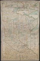
Creator:
Published / Created:
c1886.
Call Number:
814gme 1886
Container / Volume:
BRBL_00559
Image Count:
1
Resource Type:
Maps, Atlases & Globes
Alternative Title:
Map of Minnesota
Description:
Includes inset of "North east corner of Minnesota."
Publisher:
Rand McNally,
Subject (Geographic):
Minnesota--Maps
Subject (Name):
Minnesota. Office of Railroad Commissioners
Subject (Topic):
Railroads--Minnesota--Maps
Found in:
Beinecke Rare Book and Manuscript Library > Railroad commissioners' map of Minnesota / engraved and published by Rand, McNally & Co.
Creator:
Published / Created:
c1930.
Call Number:
814 1930
Container / Volume:
BRBL_00557
Image Count:
2
Resource Type:
Maps, Atlases & Globes
Description:
"Congressional districts are outlined and numbered in purple."
Publisher:
McGill-Warner Co.,
Subject (Name):
McGill-Warner Co
Subject (Topic):
Election districts--Minnesota--Maps, Railroads--Minne, Railroads--Minnesota--Duluth--Maps, Railroads--Minnesota--Maps, Railroads--Minnesota--Mesabi Range--Maps, and Railroads--Minnesota--Minneapolis--Maps
Found in:
Beinecke Rare Book and Manuscript Library > Railroad commissioners' map of Minnesota, 1930 / prepared under the direction of the commission ; compiled and published by McGill-Warner Co.
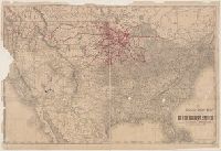
Creator:
Published / Created:
1888
Call Number:
75gme 1888
Container / Volume:
BRBL_00414
Image Count:
1
Resource Type:
Maps, Atlases & Globes
Description:
Rail connections to Duluth shown in red.
Publisher:
Rand, McNally & Co.,
Subject (Geographic):
United States--Maps
Subject (Topic):
Railroads--Minnesota--Maps and Railroads--United States--Maps
Found in:
Beinecke Rare Book and Manuscript Library > The Duluth daily news map of the Duluth railway system : Showing lines completed, under construction, and projected, Jan. 1st, 1888.
Creator:
Published / Created:
1914
Call Number:
814 1914
Container / Volume:
BRBL_00557
Image Count:
1
Resource Type:
Maps, Atlases & Globes
Description:
annotated in color pencil; verso index covered by backing.
Publisher:
Rand McNally & Co.,
Subject (Geographic):
Minnesota--Maps
Subject (Topic):
Railroads--Minnesota--Maps
Found in:
Beinecke Rare Book and Manuscript Library > The Rand-McNally new commercial atlas map of Minnesota.