Skip to search
Skip to main content
Skip to first result
Search
You Searched For
Subject (Topic)
Railroads--New England--Maps
Search Results
Creator:
Published / Created:
[1911?]
Call Number:
76gme 1910
Container / Volume:
BRBL_00446A
Image Count:
1
Resource Type:
Maps, Atlases & Globes
Alternative Title:
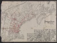
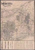
Boston and Maine Railroad and connections
Description:
St. Andrews N.B. and about there -- White Mountain region -- Mount Desert Island and vicinity.
Publisher:
The Company,
Subject (Geographic):
New England--Maps
Subject (Name):
Boston and Maine Railroad
Subject (Topic):
Railroads--New England--Maps
Found in:
Beinecke Rare Book and Manuscript Library > Boston & Maine Railroad and connections / Rand Avery Supply Co.
Creator:
Published / Created:
1886
Call Number:
76 1886
Container / Volume:
BRBL_00445
Image Count:
1
Resource Type:
Maps, Atlases & Globes
Alternative Title:
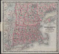
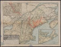
Massachusetts, Rhode Island, and Connecticut and Railroad & township map of Massachusetts, Rhode Island, and Connecticut
Description:
"Entered according to Act of Congress in the Year 1860 by J.H. Colton in the Clerks Office of the District Court for the Southern District of New York."
Publisher:
G.W. and C.B. Colton & Co.,
Subject (Geographic):
New England--Maps
Subject (Name):
Colton, J. H. (Joseph Hutchins), 1800-1893
Subject (Topic):
Railroads--New England--Maps
Found in:
Beinecke Rare Book and Manuscript Library > Colton's railroad & township map of Massachusetts, Rhode Island and Connecticut : with parts of Maine, New Hampshire, Vermont & New York.
Creator:
Published / Created:
1866, c1860.
Call Number:
753 1866C
Container / Volume:
BRBL_00415
Image Count:
1
Resource Type:
Maps, Atlases & Globes
Alternative Title:
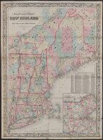
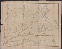
Railroad, township & distance map of New England and Railroad, township and distance map of New England
Description:
Area includes all of New England and parts of New York State, Quebec and New Brunswick.
Publisher:
G.W. and C.B. Colton & Co.,
Subject (Geographic):
Massachusetts--Maps and New England--Maps
Subject (Name):
G.W. & C.B. Colton & Co
Subject (Topic):
Railroads--Massachusetts--Maps and Railroads--New England--Maps
Found in:
Beinecke Rare Book and Manuscript Library > G. Woolworth Colton's railroad, township & distance map of New England : with adjacent portions of New York, Canada & New Brunswick.
Creator:
Published / Created:
1861
Call Number:
75 1861D
Container / Volume:
BRBL_00402
Image Count:
1
Resource Type:
Maps, Atlases & Globes
Alternative Title:
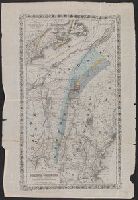
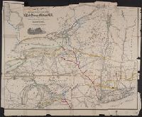
Map of the great railroad routes from the Middle Atlantic ports to the Mississippi River., Map of the railroads of New England and eastern N. York., and Map of the United States & Canada
Description:
Includes statistical charts: Population of the United States (by state and territory, 1790-1860) -- Ratio of slaves to total population -- Positions of forts.
Publisher:
G.Q. Colton,
Subject (Geographic):
Canada--Maps and United States--Maps
Subject (Topic):
Railroads--New England--Maps, Railroads--New York (State)--Maps, and Railroads--United States--Maps
Found in:
Beinecke Rare Book and Manuscript Library > Goldthwait's map of the United States & Canada : exhibiting the railroads with their distances, single and double tracks and width of gauge, and the time compared with noon at Washington & Greenwich / by J.H. Goldthwait.
Creator:
Published / Created:
1865]
Call Number:
734 1865
Container / Volume:
BRBL_00379
Image Count:
1
Resource Type:
Maps, Atlases & Globes
Alternative Title:
Golconda gold mines
Description:
"Entered according to Act of Congress in the year 1865 by J.H. Colton ..."
Publisher:
J.H. Colton,
Subject (Name):
Colton, J. H. (Joseph Hutchins), 1800-1893
Subject (Topic):
Gold mines and mining--Québec (Province)--Maps, Gold ores--Geology--Québec (Province)--Maps, Gold ores--Geology--Vermont--Maps, Railr, Railroads--New England--Maps, and Railroads--New York (State)--Maps
Found in:
Beinecke Rare Book and Manuscript Library > Map illustrating the geological position of the Golconda gold mines / by C.H. Hitchcock ; to which has been added the railway connections by J.H. Colton.
Creator:
Published / Created:
[1863]
Call Number:
76gme 1863
Container / Volume:
BRBL_00446A
Image Count:
2
Resource Type:
Maps, Atlases & Globes
Description:
"Snow's Pathfinder railway guide, week ending Saturday, July 9, 1864. Supplement."
Publisher:
Geo. K. Snow & Hapgood,
Subject (Name):
Sharp, William Comely, 1822-1897
Subject (Topic):
Railroads--New England--Maps and Railroads--New York (State)--Maps
Found in:
Beinecke Rare Book and Manuscript Library > Map of railways in the New England states : engraved expressly for Snow's Pathfinder Railway Guide. 1863.
Creator:
Published / Created:
1885
Call Number:
753gme 1885
Container / Volume:
BRBL_00415
Image Count:
2
Resource Type:
Maps, Atlases & Globes
Alternative Title:
Boston & Lowell Railroad :
Description:
Covers New England excluding Maine, and portions of eastern New York and southern Québec.
Publisher:
Rand Avery Supply Co.,
Subject (Name):
Boston and Lowell Railroad Corporation--Maps
Subject (Topic):
Railroads--New England--Maps
Found in:
Beinecke Rare Book and Manuscript Library > Map of the Boston & Lowell Railroad System : with its principal connections.
Published / Created:
1890?]
Call Number:
76 1890
Container / Volume:
BRBL_00445
Image Count:
1
Resource Type:
Maps, Atlases & Globes
Alternative Title:
Map of the Maine Central Railroad
Description:
Covers New England and the Maritime Provinces.
Publisher:
s.n.,
Subject (Geographic):
Maritime Provinces--Maps and New England--Maps
Subject (Name):
Maine Central Railroad Company--Maps and Rand Avery Supply Co
Subject (Topic):
Railroads--Maritime Provinces--Maps and Railroads--New England--Maps
Found in:
Beinecke Rare Book and Manuscript Library > Map of the Maine Central R.R. : the White Mountains & Mount Desert route / Rand Avery Supply Co., engr's.
Creator:
Published / Created:
[ca. 1851?]
Call Number:
76gme 1850
Container / Volume:
BRBL_00446A
Image Count:
1
Resource Type:
Maps, Atlases & Globes
Description:
Covers Connecticut, Rhode Island, Massachusetts, and part of New York.
Publisher:
Swett & Powers,
Subject (Name):
New York and Boston Railroad Company--Maps
Subject (Topic):
Railroads--New England--Maps
Found in:
Beinecke Rare Book and Manuscript Library > Map of the New York & Boston Railway : with its connections with other railways.
Creator:
Published / Created:
1869
Call Number:
771gme 1869
Container / Volume:
BRBL_00494
Image Count:
1
Resource Type:
Maps, Atlases & Globes
Abstract:
Map of New York State and vicinity showing drainage, canals, cities and towns, and named railroads. January 1st, 1869 edition has "W. B. Gilbert, Chief Engineer."
Description:
Description derived from published bibliography.
Subject (Name):
Gilbert, William B, New York & Oswego Midland Railroad, and New York & Oswego Midland Railroad--Maps
Subject (Topic):
Railroads--Middle Atlantic States--Maps, Railroads--New England--Maps, and Railroads--New York (State)--Maps
Found in:
Beinecke Rare Book and Manuscript Library > Map showing the location of the N.Y. & Oswego Midland R.R. with existing and proposed connection, January 1st 1869, [by Van R. Richmond, State Engr. & Surv.].