Search
You Searched For
Search Results
- Creator:
- Rand McNally and Company
- Published / Created:
- c 1888.
- Call Number:
- 793gfc P293 1888
- Container / Volume:
- BRBL_00520
- Image Count:
- 2
- Resource Type:
- Maps, Atlases & Globes
- Description:
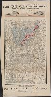
- Above upper margin: "Cross section of the property owned by the Fort Payne Coal & Iron Company, showing coal measures and red hematite ore"
- Publisher:
- Rand, McNally & Co.,
- Subject (Geographic):
- Alabama--Maps
- Subject (Name):
- Fort Payne Coal & Iron Company
- Subject (Topic):
- Coal mines and mining--Alabama--Maps, Iron mines and mining--Alabama--Maps, and Real property--Alabama--Maps
- Found in:
- Beinecke Rare Book and Manuscript Library > Map of Alabama : showing location of property owned by the Fort Payne Coal & Iron Company.