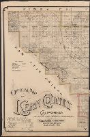
1. Official map of Kern County, California : compiled from public records and private surveys / by Creator: Congdon, Charles H Published / Created: [1898?] Call Number: 844 K459 1898 Container / Volume: BRBL_00604 Image Count: 3 Resource Type: Maps, Atlases & Globes Description: "Approved and declared to be the official map of Kern County, May 7th, 1898." Publisher: W.B. Walkup, Subject (Geographic): Kern County (Calif.)--Administrative and political divisions--Maps and Kern County (Calif.)--Maps Subject (Name): W.B. Walkup & Co Subject (Topic): Land grants--California--Kern County--Maps and Real property--California--Kern County--Maps Found in: Beinecke Rare Book and Manuscript Library > Official map of Kern County, California : compiled from public records and private surveys / by Chas. H. Congdon, County Surveyor.