Search
You Searched For
Search Results
- Creator:
- United States. Army Map Service
- Published / Created:
- 1944
- Call Number:
- 38gm 1944
- Container / Volume:
- BRBL_00170
- Image Count:
- 1
- Resource Type:
- Maps, Atlases & Globes
- Alternative Title:
- A.M.S. ; 6201 and Series (Standard map series designation system) ; 6201.
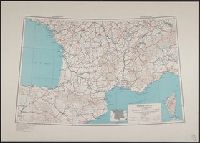
- Description:
- "Lambert conformal conic projection."
- Subject (Geographic):
- France--Maps
- Subject (Topic):
- Transportation--France--Maps
- Found in:
- Beinecke Rare Book and Manuscript Library > France [cartographic material] : Special strategic map.
- Creator:
- Great Britain. War Office. General Staff. Geographical Section
- Published / Created:
- 1914
- Call Number:
- 307 1914
- Container / Volume:
- BRBL_00036
- Image Count:
- 6
- Resource Type:
- Maps, Atlases & Globes
- Alternative Title:
- G.S.G.S. ; no. 2736 and GSGS (Series) 2736.
- Description:
- Railroads; roads; fortresses; rivers; sheets 2,3,5,6,8,9, -- coverage for France.
- Publisher:
- War Office, Geographical Section, General Staff,
- Subject (Topic):
- Transportation--France--Maps
- Found in:
- Beinecke Rare Book and Manuscript Library > Skeleton map of Western Europe (French 1/500,000) [map].