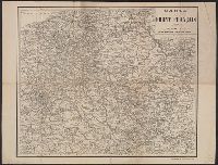
Skip to search
Skip to main content
Skip to first result
Search
You Searched For
Subject (Topic)
World War, 1914-1918--France--Maps
Search Results
Creator:
Published / Created:
[ca. 1917]
Call Number:
307hc 1917
Container / Volume:
BRBL_00036A
Image Count:
2
Resource Type:
Maps, Atlases & Globes
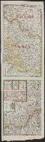
Description:
Relief shown by hachures.
Publisher:
G.W. Bacon & Co.,
Subject (Geographic):
Europe--Maps and Europe--Politics and government--Maps
Subject (Topic):
World War, 1914-1918--Belgium--Maps, World War, 1914-1918--France--Maps, and World War, 1914-1918--North Sea--Maps
Found in:
Beinecke Rare Book and Manuscript Library > Bacon's map of the seat of war in the North Sea, Belgium and eastern France.
Creator:
Published / Created:
191-
Call Number:
383 1917
Container / Volume:
BRBL_00177
Image Count:
1
Resource Type:
Maps, Atlases & Globes
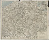
Description:
"Gravé et imprime par Charaire, à Sceaux."
Publisher:
A. Taride,
Subject (Geographic):
France--Maps
Subject (Name):
Charaire, E
Subject (Topic):
World War, 1914-1918--France--Maps
Found in:
Beinecke Rare Book and Manuscript Library > Carte du front Français [cartographic material] / A. Taride, editeur.
Creator:
Published / Created:
191-
Call Number:
383 1917
Container / Volume:
BRBL_00177
Image Count:
1
Resource Type:
Maps, Atlases & Globes
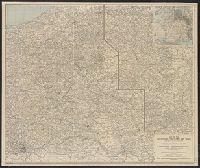
Description:
"Gravé et imprime par Charaire, à Sceaux."
Publisher:
A. Taride,
Subject (Geographic):
France--Maps
Subject (Name):
Charaire, E
Subject (Topic):
World War, 1914-1918--France--Maps
Found in:
Beinecke Rare Book and Manuscript Library > Carte du front Français [cartographic material] / A. Taride, editeur.
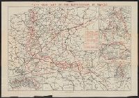
Creator:
Published / Created:
1919
Call Number:
11hc 1919
Image Count:
2
Resource Type:
Maps, Atlases & Globes
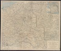
Alternative Title:
Map of the battlefields of France
Description:
"H. Barrère, éditeur-géographe."
Publisher:
Continental Daily Mail,
Subject (Geographic):
France--History--German occupation, 1914-1918--Maps
Subject (Topic):
World War, 1914-1918--France--Maps
Found in:
Beinecke Rare Book and Manuscript Library > Daily Mail map of the battlefields of France.
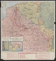
Creator:
Published / Created:
[1918?]
Call Number:
11hc 1918P
Container / Volume:
BRBL_00010F
Image Count:
1
Resource Type:
Maps, Atlases & Globes
Description:
"Redigiert von Prof. Dr. J.I. Kettler"--Bottom left corner of Nordhälfte map.
Publisher:
Carl Flemming AG.,
Subject (Geographic):
Belgium--Maps, Europe--Maps, and France--Maps
Subject (Topic):
World War, 1914-1918--Belgium--Maps, World War, 1914-1918--Europe--Maps, and World War, 1914-1918--France--Maps
Found in:
Beinecke Rare Book and Manuscript Library > Flemmings grosse Karte der Westfront [cartographic material].
Creator:
Published / Created:
1918
Call Number:
11hc 1918O
Container / Volume:
BRBL_00010F
Image Count:
2
Resource Type:
Maps, Atlases & Globes
Alternative Title:
Battle ground of freedom, Kenyon's War pocket map of the Western battle front of Europe, and Western Europe
Description:
Index of towns on verso.
Publisher:
Kenyon Company,
Subject (Geographic):
Europe--Maps and France--Maps
Subject (Topic):
World War, 1914-1918--Europe--Maps and World War, 1914-1918--France--Maps
Found in:
Beinecke Rare Book and Manuscript Library > Kenyon's Map of the western battle front [cartographic material] : "The battle ground of freedom" where our boys are fighting.
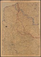
Creator:
Published / Created:
1917
Call Number:
11hc 1917F
Container / Volume:
BRBL_00010D
Image Count:
2
Resource Type:
Maps, Atlases & Globes
Alternative Title:
Western battle front no. 1, Nieuport to Reims and Western battle front, Reims, France to Basel, Switzerland
Description:
Includes 3 insets: Russo-German war front -- [Franco-German border] -- Pozieres and environs.
Publisher:
Geographical Publishing Co.,
Subject (Geographic):
Europe--Maps, France--Maps, Germany--Maps, Poland--Maps, and Russia--Maps
Subject (Topic):
World War, 1914-1918--Europe--Maps, World War, 1914-1918--France--Maps, World War, 1914-1918--Germany--Maps, World War, 1914-1918--Poland--Maps, and World War, 1914-1918--Russia--Maps
Found in:
Beinecke Rare Book and Manuscript Library > Map of the Franco-German war front : from Hirson, France to Basel, Switzerland, and the Russo-German war front from Riga, Russia, to Lemberg, Austria / Published for the Volume Library.
Creator:
Published / Created:
1918
Call Number:
30 1918B
Container / Volume:
BRBL_00032A
Image Count:
1
Resource Type:
Maps, Atlases & Globes
Alternative Title:
Index to the map of the Western Theatre of War.
Description:
Detached from: National Geographic, May 1918.
Publisher:
The Society,
Subject (Geographic):
Alsace (France)--Maps, Europe--Maps, and Lorraine (France)--Maps
Subject (Topic):
World War, 1914-1918--Belgium--Maps, World War, 1914-1918--France--Maps, and World War, 1914-1918--Maps
Found in:
Beinecke Rare Book and Manuscript Library > Map of the Western Theatre of War / Prepared in the Map Dept. of the National Geographic Society for the National Geographic Magazine ; A. H. Bumstead, cartographer.
Creator:
Published / Created:
1918
Call Number:
11hc 1918C
Container / Volume:
BRBL_00010E
Image Count:
1
Resource Type:
Maps, Atlases & Globes
Alternative Title:
Index to the map of the Western Theatre of War.
Description:
Detached from: National Geographic, May 1918.
Publisher:
The Society,
Subject (Geographic):
Alsace (France)--Maps, Europe--Maps, and Lorraine (France)--Maps
Subject (Topic):
World War, 1914-1918--Belgium--Maps, World War, 1914-1918--France--Maps, and World War, 1914-1918--Maps
Found in:
Beinecke Rare Book and Manuscript Library > Map of the Western Theatre of War / Prepared in the Map Dept. of the National Geographic Society for the National Geographic Magazine ; A. H. Bumstead, cartographer.