Search
You Searched For
Search Results
- Creator:
- E. B
- Published / Created:
- 1915?]
- Call Number:
- 30 1915F
- Container / Volume:
- BRBL_00032A
- Image Count:
- 1
- Resource Type:
- Maps, Atlases & Globes
- Alternative Title:
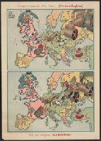
- Año despues !!la realidad!! and Serio-comique map of Europe at war.
- Description:
- After Johnson, Riddle & Co.'s Serio-comique map of Europe at war.
- Publisher:
- s.n.,
- Subject (Geographic):
- Europe--Maps and Europe--Politics and government--Maps
- Subject (Topic):
- World War, 1914-1918--Caricatures and cartoons and World War, 1914-1918--Maps
- Found in:
- Beinecke Rare Book and Manuscript Library > Europa al principio de la guerra ; Un año despues !!la realidad!! / [por] EB.
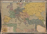
- Creator:
- Denoyer-Geppert Company
Harding, Samuel Bannister, 1866-1927
- Published / Created:
- c1914.
- Call Number:
- 30fab 1914
- Container / Volume:
- BRBL_00037B
- Image Count:
- 1
- Resource Type:
- Maps, Atlases & Globes
- Alternative Title:
- Europe 1914.
- Description:
- Imperfect: mutilated with loss of text.
- Publisher:
- Denoyer-Geppert Co.,
- Subject (Geographic):
- Europe--History--1871-1918--Maps
- Subject (Topic):
- World War, 1914-1918--Maps
- Found in:
- Beinecke Rare Book and Manuscript Library > Europe in 1914 before the Great War / by Samuel B. Harding ; L. Philip Denoyer, geographer ; compiled and drawn by R. Baxter Blair.
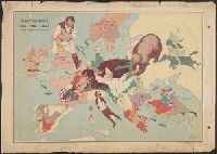
- Creator:
- Amshewitz, J. H. (John Henry), 1882-1942
Geographia Ltd
- Published / Created:
- 1914
- Call Number:
- 30 1914E
- Container / Volume:
- BRBL_00032A
- Image Count:
- 1
- Resource Type:
- Maps, Atlases & Globes
- Description:
- Caricature map.
- Publisher:
- "Geographia" Ltd.,
- Subject (Geographic):
- Europe--Maps
- Subject (Topic):
- International relations--20th century--Maps, World War, 1914-1918--Caricatures and cartoons, and World War, 1914-1918--Maps
- Found in:
- Beinecke Rare Book and Manuscript Library > European revue : kill that eagle / produced by "Geographia" Ltd. ; [drawn by] J.H.A.
- Published / Created:
- 1914
- Call Number:
- 11hc 1914E
- Container / Volume:
- BRBL_00010A
- Image Count:
- 1
- Resource Type:
- Maps, Atlases & Globes
- Description:
- "R6" printed to left of scale statement.
- Publisher:
- Army Service Schools,
- Subject (Geographic):
- Europe--Maps
- Subject (Topic):
- World War, 1914-1918--Maps
- Found in:
- Beinecke Rare Book and Manuscript Library > European war zone map / made at Army Service Schools, Fort Leavenworth, Kas.
- Published / Created:
- 1918?]
- Call Number:
- 38hc 1918A Sep. folder
- Container / Volume:
- BRBL_00172
- Image Count:
- 1
- Resource Type:
- Maps, Atlases & Globes
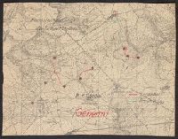
- Description:
- Accompanied by sheet containing overlay diagrams "Sperrfeuer Remenauville" and "Sperrfeuer: Mort-Mare-Wald".
- Publisher:
- s.n.,
- Subject (Geographic):
- Champagne-Ardenne (France)--Maps and Lorraine (France)--Maps
- Subject (Topic):
- Electric lines, Telephone lines, World War, 1914-1918--France--Lorraine, and World War, 1914-1918--Maps
- Found in:
- Beinecke Rare Book and Manuscript Library > Fernsprechleitungen der Schaltstellen.
- Published / Created:
- 1918?]
- Call Number:
- 38hc 1918C
- Container / Volume:
- BRBL_00172
- Image Count:
- 1
- Resource Type:
- Maps, Atlases & Globes
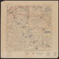
- Description:
- "Abgeschlossen am 18.7.18".
- Publisher:
- s.n.,
- Subject (Geographic):
- Lorraine (France)--Military maps
- Subject (Topic):
- World War, 1914-1918--France--Lorraine and World War, 1914-1918--Maps
- Found in:
- Beinecke Rare Book and Manuscript Library > Grabenkarte.
- Published / Created:
- 1918?]
- Call Number:
- 38hc 1918B
- Container / Volume:
- BRBL_00172
- Image Count:
- 6
- Resource Type:
- Maps, Atlases & Globes
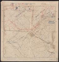
- Description:
- Legend indicates trench information in red and blue ink.
- Publisher:
- s.n.,
- Subject (Geographic):
- Lorraine (France)--Military maps
- Subject (Topic):
- World War, 1914-1918--France--Lorraine and World War, 1914-1918--Maps
- Found in:
- Beinecke Rare Book and Manuscript Library > Grabenkarten.
- Published / Created:
- 1918?]
- Call Number:
- 38hc 1918D
- Container / Volume:
- BRBL_00172
- Image Count:
- 2
- Resource Type:
- Maps, Atlases & Globes
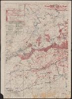
- Description:
- "19./6.-26./6./18".
- Publisher:
- s.n.,
- Subject (Geographic):
- Île-de-France (France)--Military maps and Lorraine (France)--Military maps
- Subject (Topic):
- World War, 1914-1918--France--Lorraine and World War, 1914-1918--Maps
- Found in:
- Beinecke Rare Book and Manuscript Library > Gruppe Gorz, Ic/IId No. 62 geh. Artillerie-Wochenkarte mit Truppen und Fliegerbilderkundung.
- Published / Created:
- [1917?]
- Call Number:
- 36hc 1917
- Container / Volume:
- BRBL_00133
- Image Count:
- 1
- Resource Type:
- Maps, Atlases & Globes
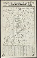
- Description:
- Index to names in margins.
- Publisher:
- Hobian Map Co.,
- Subject (Geographic):
- France--Maps and Germany--Maps
- Subject (Name):
- C.S. Hammond & Company Stamp
- Subject (Topic):
- World War, 1914-1918--Maps
- Found in:
- Beinecke Rare Book and Manuscript Library > Home Headquarters Map : French and German Frontiers.
- Published / Created:
- [1917?]
- Call Number:
- 36hc 1917a
- Container / Volume:
- BRBL_00133
- Image Count:
- 1
- Resource Type:
- Maps, Atlases & Globes
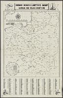
- Description:
- Index to names in margins.
- Publisher:
- Hobian Map Co.,
- Subject (Geographic):
- Germany--Maps and Poland--Maps
- Subject (Name):
- C.S. Hammond & Company Stamp
- Subject (Topic):
- World War, 1914-1918--Maps
- Found in:
- Beinecke Rare Book and Manuscript Library > Home Headquarters Map : German and Polish Frontiers.