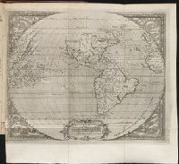
Map of all the world in two hemispheres in which are exactly described all the parts of the earth and seas
Description:
Dedicated To the most serene and most sacred majesty of Charles II ..., Described by Sanson ; corrected and amended by William Berry., Includes coat of arms and decorative cartouche containing dedication., No. 1 of 69 maps bound together in composite atlas., Prime meridian: Ferro., Relief shown pictorially., Scale [ca. 1:60 000 000]., and Shows California as an island.
Publisher:
Sold by William Berry at ye sign of the globe between Charing-Cross and White-Hall
Subject (Geographic):
Eastern Hemisphere --Maps --Early works to 1800 and Western Hemisphere --Maps --Early works to 1800
Map of the world showing routes of Cook's expeditions, with notes on ice, wild life etc. seen. Relief shown pictorially; imaginary coastline for eastern coast of Australian Bight., No. 1 of 43 maps bound together in composite atlas., and Scale [ca.1:68 000 000].
Publisher:
Published by Wm. Faden, Geographer to the King, Charing Cross
Subject (Name):
Cook, James, 1728-1779 and Mulgrave, Constantine John Phipps, Lord
Subject (Topic):
Discoveries in geography --Maps --To 1800 and World maps --Early works to 1800
Twenty four new and accurate maps of the several parts of Europe ... : all (except the last) new
Image Count:
1
Alternative Title:
The world in general
Description:
In pencil on verso: 1.
Subject (Name):
Barker, B. (Benjamin), d. 1764, bookseller, Clements, Henry, d. 1719, bookseller, King, Charles, d. 1735, bookseller, Nicholson, John, d. ca. 1717, bookseller, Parker, Richard, fl. 1692-1725, bookseller, and Tooke, Benjamin, d. 1716, bookseller
Subject (Topic):
Atlases --Early works to 1800 and World maps --Early works to 1800
Collection Created:
[London] : Sold by J. Nicholson at the King’s-Arms in Little Britain, Benj. Barker and Charles King ..., Benj. Tooke ..., Hen. Clements ..., R. Parker and Ralph Smith under the Royal-Exchange ..., [1715?]
Eastern old world hemisphere has imprint: London ... Dec. 1st, 1786 by William Faden., No. 2 of 43 maps bound together in composite atlas., Scale [1:60,000,000]., and Shows western and eastern hemispheres separately.
Ed. statement appears on Northern Hemisphere map only., No. 3 of 43 maps bound together in composite atlas., Relief shown pictorially., Scale [ca. 1:41,000,000. At equator]., and Shows tracks of various ocean voyages.
Publisher:
William Faden
Subject (Geographic):
Northern Hemisphere --Maps --Early works to 1800 and Southern Hemisphere --Maps --Early works to 1800
De orbe novo Petri Martyris Anglerii Mediolanensis, protonotarij, & Caroli quinti Senatoris decades
Image Count:
1
Description:
Copy of map published in Hakluyt's Voyages in 1587., Preceding p. 1., and Teaching resource: Professor John Mack Faragher, History 141: The American West.
Subject (Geographic):
America --Discovery and exploration, Latin America --Description and travel, and West Indies --History
Mecometrie de leymant, cest a dire La maniere de mesvrer les longitudes par le moyen de l’eymant
Image Count:
1
Description:
Bound in preceding t.p. for pt. [2] (Premier livre de la Mecometrie arithmetique de l’eymant)., Imperfect: map rubbed, with some loss of map and text., Map has small tear on left edge at gutter., and Scale [ca. 1:100,000,000].
Subject (Topic):
Longitude --Early works to 1800 and World maps --Early works to 1800