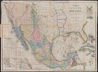
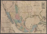
1.

- Creator:
- Disturnell, John, 1801-1877
- Published / Created:
- 1935
- Call Number:
- 88 1847H
- Container / Volume:
- BRBL_00645
- Image Count:
- 1
- Resource Type:
- Maps, Atlases & Globes
- Alternative Title:
- Department of State publication ; 803. and Department of State, map series ; no. 5 (Publication no. 803)
- Description:
- "Reproduced in 1935 to accompany ʻTreaties and other international acts of the United States of America,ʾ Volume 5. See Document 129.", "The earliest of five or more 1847 editions. The copy added to the Treaty of Guadalupe Hidalgo of February 2, 1848, in the archives of the Department of State.", Includes table of distances, table of statistics, "Profile of the route between Mexico and Vera Cruz," and "Profile of the route b[e]tween Mexico and Acapulco.", Insets: Carta de los caminos &c. desde Vera Cruz y Alvarado a Méjico -- Map showing the battle grounds of the 8th and 9th May 1846 -- Chart of the bay of Vera Cruz., Prime meridian: Washington., and Relief shown by hachures and spot heights.
- Publisher:
- Department of State,
- Subject (Geographic):
- Mexico--Maps and Southwest, New--Maps
- Subject (Name):
- A. Hoen & Co and United States. Treaties, etc
- Subject (Topic):
- United States--Foreign relations--Treaties--Maps
- Found in:
- Beinecke Rare Book and Manuscript Library > Mapa de los Estados Unidos de Méjico / segun lo organizado y definido por las varias actas del Congreso de dicha República y construido por las mejores autoridades ; lo publican, J. Disturnell.