Skip to search
Skip to main content
Skip to first result
Search
You Searched For
Genre
Maps
Subject (Geographic)
Europe, Central--Maps
New Search
Search Results
Creator:
Published / Created:
1914
Call Number:
304 1914
Container / Volume:
BRBL_00034
Image Count:
1
Resource Type:
Maps, Atlases & Globes
Alternative Title:
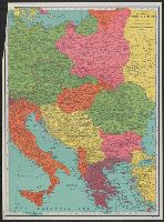
Map of the new Balkan states and Central Europe.
Description:
Issued with National Geographic magazine, vol. 26, no. 2, August, 1914. and Mounted on linen.
Publisher:
Edinburgh Geographical Institute,
Subject (Geographic):
Balkan Peninsula--Maps and Europe, Central--Maps
Subject (Name):
Edinburgh Geographical Institute
Found in:
Beinecke Rare Book and Manuscript Library > The National Geographic magazine map of the new Balkan states and Central Europe / prepared by J.G. Bartholomew ; Gilert H. Grosvenor, Editor.
Creator:
Published / Created:
1914
Call Number:
304 1914
Container / Volume:
BRBL_00034
Image Count:
1
Resource Type:
Maps, Atlases & Globes
Alternative Title:
Map of the new Balkan states and Central Europe.
Description:
Issued with National Geographic magazine, vol. 26, no. 2, August, 1914.
Publisher:
Edinburgh Geographical Institute,
Subject (Geographic):
Balkan Peninsula--Maps and Europe, Central--Maps
Found in:
Beinecke Rare Book and Manuscript Library > The National Geographic magazine map of the new Balkan states and Central Europe / prepared by J.G. Bartholomew ; Gilert H. Grosvenor, Editor.
Creator:
Published / Created:
[1914]
Call Number:
44 1914B
Container / Volume:
BRBL_00256
Image Count:
1
Resource Type:
Maps, Atlases & Globes
Alternative Title:
Map of the new Balkan states and central Europe
Description:
Issued with National Geographic magazine, vol. 26, no. 2, August, 1914. and Relief shown by spot heights.
Publisher:
Edinburgh Geographical Institute, and National Geographic Society] ;
Subject (Geographic):
Balkan Peninsula--Maps and Europe, Central--Maps
Subject (Name):
Edinburgh Geographical Institute and Grosvenor, Gilbert Hovey, 1875-1966
Found in:
Beinecke Rare Book and Manuscript Library > The National geographic magazine map of the new Balkan states and central Europe [cartographic material] / prepared by J.G. Bartholomew ; Gilbert H. Grosvenor, editor.
Creator:
Published / Created:
[1939?]
Call Number:
30 1940E
Container / Volume:
BRBL_00032B
Image Count:
1
Resource Type:
Maps, Atlases & Globes
Alternative Title:
War map of Central Europe.
Description:
"Longitude east of Greenwich." and Relief shown hachures.
Publisher:
Rand McNally & Co.,
Subject (Geographic):
Europe, Central--Maps
Subject (Topic):
World War, 1939-1945--Europe, Central--Maps
Found in:
Beinecke Rare Book and Manuscript Library > The Rand McNally war map of Central Europe.
Creator:
Published / Created:
1945
Call Number:
42eb 1945
Container / Volume:
BRBL_00245
Image Count:
1
Resource Type:
Maps, Atlases & Globes
Description:
"No. 8305.", Includes 2 inset maps., and Shows areas of Hungarian population, roads, railroads, etc.
Publisher:
Reproduction Branch, SSU,
Subject (Geographic):
Europe, Central--Maps
Subject (Topic):
Hungarians--Europe, Central--Maps
Found in:
Beinecke Rare Book and Manuscript Library > The border areas: Austria, Hungary, Czechoslovakia [cartographic material] / R & A, IRIS.
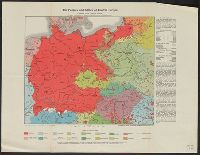
Creator:
Published / Created:
s.a. [ca. 1922]
Call Number:
304ed 1920
Container / Volume:
BRBL_00034A
Image Count:
1
Resource Type:
Maps, Atlases & Globes
Publisher:
Kartographisches, früher Militärgeographisches Inst.
Subject (Geographic):
Europe, Central--Maps
Found in:
Beinecke Rare Book and Manuscript Library > The peoples and states of Central Europe compiled by Wilhelm Winkler
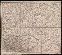
Creator:
Published / Created:
1882-1886.
Call Number:
304 1886
Container / Volume:
Series Box 1
Image Count:
4
Resource Type:
Maps, Atlases & Globes
Description:
Copy 3: Imperfect: all sheets but C2, C3, and D3 wanting., Covers Europe from western France to eastern Russia, and from the North Sea to the Aegean Sea., and Relief shown by hachures and spot heights.
Publisher:
K.K. Militär-geographisches Institute,
Subject (Geographic):
Europe, Central--Maps
Found in:
Beinecke Rare Book and Manuscript Library > Übersichts-Karte von Mittel-Europa, im Masse 1:750.000 der Natur / bearbeitet und herausgegeben vom K.K. Militär-geographischen Institute.
Creator:
Published / Created:
1882-1886.
Call Number:
304 1886
Container / Volume:
Series Box 1
Image Count:
49
Resource Type:
Maps, Atlases & Globes
Description:
Covers Europe from western France to eastern Russia, and from the North Sea to the Aegean Sea., Includes sheet index., Introductory sheets include title, location map, glossary, and legend., Pronunciation guide and abbreviations in 8 languages., Relief shown by hachures and spot heights., and Sheet title and scale bars affixed to verso. Only sheet F.6 verso digitized as reference.
Publisher:
K.K. Militär-geographisches Institute,
Subject (Geographic):
Europe, Central--Maps
Found in:
Beinecke Rare Book and Manuscript Library > Übersichts-Karte von Mittel-Europa, im Masse 1:750.000 der Natur / bearbeitet und herausgegeben vom K.K. Militär-geographischen Institute.
Creator:
Published / Created:
1882-1886.
Call Number:
304 1886
Container / Volume:
Series Box 1
Image Count:
6
Resource Type:
Maps, Atlases & Globes
Description:
Copy 2: Imperfect: all sheets but C1, C2, D1, D2, E1 and E2 wanting., Covers Europe from western France to eastern Russia, and from the North Sea to the Aegean Sea., and Relief shown by hachures and spot heights.
Publisher:
K.K. Militär-geographisches Institute,
Subject (Geographic):
Europe, Central--Maps
Found in:
Beinecke Rare Book and Manuscript Library > Übersichts-Karte von Mittel-Europa, im Masse 1:750.000 der Natur / bearbeitet und herausgegeben vom K.K. Militär-geographischen Institute.
Creator:
Published / Created:
1887
Call Number:
304ed 1887
Container / Volume:
BRBL_00034A
Image Count:
1
Resource Type:
Maps, Atlases & Globes
Publisher:
Dietrich Reimer,
Subject (Geographic):
Europe, Central--Maps
Subject (Topic):
Linguistic geography--Germany--Maps
Found in:
Beinecke Rare Book and Manuscript Library > Übersichtskarte der Verbreitung der Deutschen in Europa.
Branch:v1.65.8 ,Deployed:2025-04-06T22:39:31-04:00