"A hut with a door at the front, with logs next to the door and in a pile in front of the hut to the right."--British Museum online catalogue
Description:
Title engraved below image., Sheet trimmed within plate mark., "Engrav'd for the Ladys Magazine"--Above image., and Plate from: The lady's magazine, or, Entertaining companion for the fair sex, v. 16 (February 1785).
Publisher:
Published March 1st, 1785, by G. Robinson
Subject (Geographic):
Alaska and Alaska.
Subject (Topic):
Discovery and exploration, Indians of North America, and Huts
Print shows a view of a settlement at Goulding's Harbor, a side channel of Portlock's Harbor between Sitka and Juneau in Alaska, visited by the ships King George and Queen Charlotte and Captains Portlock and Dixon. Two men holding rope, pulling small boat to shore; two other figures, Native persons, on opposite bank, with two small buildings; woods and rocky hillsides
Description:
BEIN BrSide4o Zc70 789vi: On sheet 18.3 x 23,0 cm. and Title from caption below image.
Publisher:
Publish'd by J. Stockdale & G. Goulding
Subject (Geographic):
Northwest Coast of North America and Alaska
Subject (Topic):
Indians of North America, Voyages around the world, and Discovery and exploration
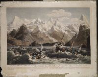
BEIN BrSides Elephant Folio Zc86 800cr: Imperfect: chipped and torn along edges. Backed with paper., Engraving showing the shipwreck of two small boats that were part of the La Perouse Expedition, during their reconnaissance of Lituya Bay, near Juneau, Alaska., and "Deposé à Bibliotheque Imperiale."
Publisher:
Chez Ostervald l'ain Rue du petit Lion St. Sulpice, No. 20 and Imprimé par Bassand
Subject (Geographic):
Alaska
Subject (Name):
La Pérouse, Jean-François de Galaup, comte de, 1741-1788
Geological and Geographical Survey of the Territories (U.S.)
Published / Created:
1873.
Call Number:
WA Photos Folio 53
Container / Volume:
Volume (copy 1)
Image Count:
93
Abstract:
Two versions of a viewbook distributed by the United States Geological and Geographical Survey of the Territories in 1873 with mounted photographic prints created by William Henry Jackson of camps, geothermal features, and landscape primarily in Yellowstone National Park and Montana, 1872, Images of camps established by members of the United States Geological Survey include sites in the Lower Firehole River Basin of Yellowstone National Park; at the mouth of Teton Canyon, Montana; on the shore of Mystic Lake, Gallatin County, Montana; in the Wasatch Mountains near Ogden, Utah; and at Fort Hall, Idaho, Images of geothermal features in the Upper Geyser Basin of Yellowstone National Park include the crater of Old Faithful, the Grand Geyser in eruption, Castle Geyser, and the crater of Grotto Geyser, Images of geothermal features in the Lower Basin of Yellowstone National Park consist of several views of Mammoth Hot Springs on the Gardner River and a view of the calcium carbonate cone known as Cap of Liberty, An image shows the Architectural Geyser in the Lower Firehole River Basin of Yellowstone National Park, Images of rivers in Yellowstone National Park include views along the Yellowstone River consisting of the Upper Falls, the Lower Falls, and the Grand Canyon of the Yellowstone River, as well as a view of Tower Fall, a waterfall on Tower Creek. Several images depict the Yellowstone River Valley, Images of Gallatin County, Montana, include a view of the Needle, a rock pinnacle in Bridger Canyon; views of Mystic Lake; views of the Gallatin River include trails along the river and the walls of Gallatin Canyon, as well as Arched Falls; and views of Mount Blackmore and its vicinity that include views of the mountain and Palace Butte, and Images of mountains in what became Grand Teton National Park, Wyoming, include Grand Teton (referred to as Mount Hayden) and the Teton Range
Description:
Each photograph is accompanied by a guard sheet with descriptive letter-press captions., Photographs on mounts of the United States Geological and Geographical Survey of the Territories., Both volumes have the same contents of photographic prints with variations in the orientation of prints and the binding., and One volume possesses slightly more gilded ornamentation on its boards as well as gilded edges to the individual mounts.
Publisher:
Government Printing Office
Subject (Geographic):
Yellowstone National Park., Blackmore, Mount (Mont.), Bridger Canyon (Mont.), Firehole River (Wyo.), Fort Hall (Idaho : Fort), Gallatin Canyon (Mont.), Gallatin River (Wyo. and Mont.), Grand Teton (Wyo.), Grand Teton National Park (Wyo.), Idaho, Lower Falls of the Yellowstone River (Wyo.), Mammoth Hot Springs (Wyo.), Montana, Teton Range (Wyo. and Idaho), Tower Creek (Wyo.), Upper Falls of the Yellowstone River (Wyo.), Upper Geyser Basin (Wyo.), Utah, Wasatch Range (Utah and Idaho), Wyoming, Yellowstone National Park, Yellowstone River, and Yellowstone River Valley
Subject (Name):
Jackson, William Henry, 1843-1942. and Geological and Geographical Survey of the Territories (U.S.)
Subject (Topic):
Discoveries in geography, American, Rock formations, United States, Discovery and exploration, and Surveys
Geological and Geographical Survey of the Territories (U.S.)
Published / Created:
1873.
Call Number:
WA Photos Folio 53
Container / Volume:
Volume (copy 2)
Image Count:
94
Abstract:
Two versions of a viewbook distributed by the United States Geological and Geographical Survey of the Territories in 1873 with mounted photographic prints created by William Henry Jackson of camps, geothermal features, and landscape primarily in Yellowstone National Park and Montana, 1872, Images of camps established by members of the United States Geological Survey include sites in the Lower Firehole River Basin of Yellowstone National Park; at the mouth of Teton Canyon, Montana; on the shore of Mystic Lake, Gallatin County, Montana; in the Wasatch Mountains near Ogden, Utah; and at Fort Hall, Idaho, Images of geothermal features in the Upper Geyser Basin of Yellowstone National Park include the crater of Old Faithful, the Grand Geyser in eruption, Castle Geyser, and the crater of Grotto Geyser, Images of geothermal features in the Lower Basin of Yellowstone National Park consist of several views of Mammoth Hot Springs on the Gardner River and a view of the calcium carbonate cone known as Cap of Liberty, An image shows the Architectural Geyser in the Lower Firehole River Basin of Yellowstone National Park, Images of rivers in Yellowstone National Park include views along the Yellowstone River consisting of the Upper Falls, the Lower Falls, and the Grand Canyon of the Yellowstone River, as well as a view of Tower Fall, a waterfall on Tower Creek. Several images depict the Yellowstone River Valley, Images of Gallatin County, Montana, include a view of the Needle, a rock pinnacle in Bridger Canyon; views of Mystic Lake; views of the Gallatin River include trails along the river and the walls of Gallatin Canyon, as well as Arched Falls; and views of Mount Blackmore and its vicinity that include views of the mountain and Palace Butte, and Images of mountains in what became Grand Teton National Park, Wyoming, include Grand Teton (referred to as Mount Hayden) and the Teton Range
Description:
Each photograph is accompanied by a guard sheet with descriptive letter-press captions., Photographs on mounts of the United States Geological and Geographical Survey of the Territories., Both volumes have the same contents of photographic prints with variations in the orientation of prints and the binding., and One volume possesses slightly more gilded ornamentation on its boards as well as gilded edges to the individual mounts.
Publisher:
Government Printing Office
Subject (Geographic):
Yellowstone National Park., Blackmore, Mount (Mont.), Bridger Canyon (Mont.), Firehole River (Wyo.), Fort Hall (Idaho : Fort), Gallatin Canyon (Mont.), Gallatin River (Wyo. and Mont.), Grand Teton (Wyo.), Grand Teton National Park (Wyo.), Idaho, Lower Falls of the Yellowstone River (Wyo.), Mammoth Hot Springs (Wyo.), Montana, Teton Range (Wyo. and Idaho), Tower Creek (Wyo.), Upper Falls of the Yellowstone River (Wyo.), Upper Geyser Basin (Wyo.), Utah, Wasatch Range (Utah and Idaho), Wyoming, Yellowstone National Park, Yellowstone River, and Yellowstone River Valley
Subject (Name):
Jackson, William Henry, 1843-1942. and Geological and Geographical Survey of the Territories (U.S.)
Subject (Topic):
Discoveries in geography, American, Rock formations, United States, Discovery and exploration, and Surveys