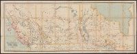
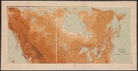
Shows proposed railroads primarily in the North Central United States and Canada; bullseye centering on Mackinaw City and the Great Lakes region and the Straits of Mackinaw connecting Lake Michigan and Lake Huron; Michigan counties, major cities and t...
Publisher:
Middleton, Strobridge & Co.,
Subject (Geographic):
Canada--Maps, Great Lakes (North America)--Maps, and Middle West--Maps
Subject (Name):
Canadian Pacific Railway Company--Maps and Northern Pacific Railroad Company--Maps
Subject (Topic):
Counties--Michigan--Maps, Mines and mineral resources--Canada--Maps, Railroads--Canada--Maps, and Railroads--Great Lakes (North America)--Maps
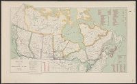
Canadian Pacific Railway Company, Duluth, South Shore, and Atlantic Railway Company, Duluth, South Shore, and Atlantic Railway Company--Maps, and Spokane International Railway--Maps
Subject (Topic):
Railroads--Canada--Maps and Railroads--United States--Maps
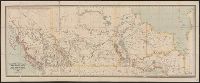
Sportsman's map of Canada and the Northwest Territory.
Description:
Date taken from Yale card catalog indicating map was originally in cover with date of issue, March 1901; also with a cover title, "The sportsman's map of Canada and the Northwest Territory."
Publisher:
Poole Bros.,
Subject (Geographic):
Canada--Maps and United States--Maps
Subject (Name):
Canadian Pacific Railway Company, Canadian Pacific Railway Company--Maps, Duluth, South Shore, and Atlantic Railway Company, and Duluth, South Shore, and Atlantic Railway Company--Maps
Subject (Topic):
Railroads--Canada--Maps and Railroads--United States--Maps
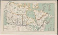
Includes distances from Montreal to other cities in Canada, costs of railways operations in 1907, mileage operated in 1907 and "Railway mileage by provinces, 1907."