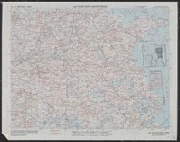
Asiatic series, No. 34, Southeast China, No. C40, Luzon Island, and Philippine series
Description:
Includes index to sheets, wind force and steadiness of direction of currents., On verso: Chart No. No. 34, Southeast China., and Relief shown by gradient tints, contours, and spot heights.
Publisher:
Army Map Service,
Subject (Geographic):
China, Southeast--Maps and Luzon (Philippines)--Maps
Subject (Topic):
Aeronautical charts--China, Southeast--Maps, Aeronautical charts--Philippines--Luzon--Maps, Military geography--China, Southeast--Maps, Military geography--Philippines--Luzon--Maps, and World War, 1939-1945--Campaig
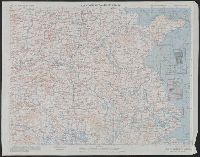
Shows roads, boundaries, railroads, power transmission lines, cities, towns, rivers, swamps, reefs and shoals.
Alternative Title:
AAF cloth map. and Asiatic series
Description:
"Officers using this chart will mark hereon corrections and addition, Aviator's survival map, printed on cloth., No. 34. Southeast China -- no. 35. Northeast China., Relief shown by hachures and spot heights (China)., and Shows wind directions and ocean currents.
Publisher:
Army Map Service, U.S. Army,
Subject (Geographic):
China, Southeast--Maps and Southeast Asia--Maps
Subject (Name):
United States. Aeronautical Chart Service and United States. Army Air Forces
Subject (Topic):
Military maps, Ocean currents--China--Maps, and Winds--China--Maps
Shows roads, boundaries, railroads, power transmission lines, cities, towns, rivers, swamps, reefs and shoals.
Alternative Title:
AAF cloth map. and Asiatic series
Description:
"Officers using this chart will mark hereon corrections and additions which come to their attention and mail dire, No. 34. Southeast China -- no. 35. Northeast China., Originally issued as a restricted map., and Relief shown by hachures and spot heights (China).
Publisher:
Army Map Service, U.S. Army,
Subject (Geographic):
China, Southeast--Maps and Southeast Asia--Maps
Subject (Name):
United States. Aeronautical Chart Service and United States. Army Air Forces
Subject (Topic):
Military maps, Ocean currents--China--Maps, and Winds--China--Maps
Shows roads, boundaries, railroads, power transmission lines, cities, towns, rivers, swamps, reefs and shoals.
Alternative Title:
AAF cloth map. and Asiatic series
Description:
"Officers using this chart will mark hereon corrections and additions which come to their attention and mail direct to 'Aeronautical Chart Service, Headquarters Army Air Forces, Washington, D.C.'"--Lower and Relief shown by hachures and spot heights (China).
Publisher:
Army Map Service, U.S. Army,
Subject (Geographic):
China, Southeast--Maps and Southeast Asia--Maps
Subject (Name):
United States. Aeronautical Chart Service and United States. Army Air Forces
Subject (Topic):
Military maps, Ocean currents--China--Maps, and Winds--China--Maps