"Entered according to Act of Congress in the year 1850 by John Monk in the Clerks Office of the District of Maryland.", Includes: Legend, Table of distances, routes by water, inland routes, Names of counties and county towns in the United States., and Inset: Ne
Publisher:
Jacob Monk,
Subject (Geographic):
Central America--Maps, Mexico--Maps, North America--Maps, United States--Maps, and West Indies--Maps
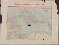
East Indies., Showing Spanish possessions in East Indies., and West Indies.
Description:
Also shows Central America and shipping routes., Alternate title: West Indies ; East Indies., Includes col. ill. of United States and Cuba flags., Map of West Indies includes inset., and Relief shown by hachures.
Publisher:
Geo. F. Cram, engraver and publisher,
Subject (Geographic):
Caribbean Area--Maps, East Indies--Maps, and West Indies--Maps
"Supplement to the Evening Post, Wednesday, May 25th, 1898.", Includes insets of Philippine Islands, Atlantic Ocean showing relation of Spain to West Indies, and Harbour of Havana., Margin title., Mounted on linen., and Relief shown by hachures.
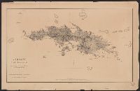
Cover title: Map of Cuba, Porto Rico, and Jamaica : with map of the Plant System of railway, steamer, and steamship lines and connections., Ill. and advertisement on verso., and Insets: Porto Rico.--West Indies.--Havana.--Matanzas.--Cienfuegos.--Santiago de Cuba.
Publisher:
Matthews-Northrup Co.,
Subject (Geographic):
Cuba--Maps, Jamaica--Maps, Puerto Rico--Maps, and West Indies--Maps
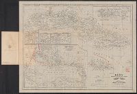
"L. Olszewski, Washington, D.C." in bottom left margin., "U.S. Treasury, Bureau of Statistics" in bottom center margin., and Siganture "O.P. Austin, Chief of Bureau" in bottom right margin.
Insets: Guantanamo Bay, Cuba. Scale [ca. 1:400,000] -- Porto Rico and the Virgin Islands. Scale [ca. 1:1,300,000] -- The Panama Canal and the Canal Zone [with cross-section showing extent of c and Shows steamship routes and U.S. consular offices and agencies.
Publisher:
The Society,
Subject (Geographic):
Canal Zone--Maps, Central America--Maps, Mexico--Maps, and West Indies--Maps
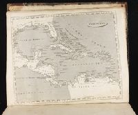
"Entered according to Act of Congress in the year 1838 by T.G. Bradford in the ... District Court of Massachusetts.", From T.G Bradford's Illustrated atlas ... Boston : Weeks, Jordan, and Co. ; New York : Wiley and Putnam, [1838], and Relief shown by hachures.
Publisher:
T.G. Bradford,
Subject (Geographic):
Caribbean Area--Maps and West Indies--Maps
Subject (Name):
Bradford, T.G. (Thomas Gamaliel), 1802-1887. Illustrated atlas, Weeks, Jordan & Company, and Wiley & Putnam